Enable Location

We need your location to show you interesting places around you

Discover nearby places

Find interesting locations and hidden gems around you

Precise directions

Get accurate directions and distances to places

Your location is never shared with other users. It's only used when you tap the location button.

Log in to your account

Start exploring — it's free

Trusted by 63,009 travelers worldwide

Continue with Google
Continue with Apple
or

We will send you a code to connect

By continuing, you accept our Terms and Conditions and our Privacy Policy

Check your inbox

We've sent a pincode in your inbox. Please enter the code below.

Pine Mountain Trail State Park
Discussion Reviews Photo
1.8k Popularity

Pine Mountain Trail State Park, State park and hiking trail system in southeastern Kentucky, United States.

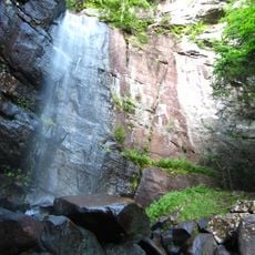
Pine Mountain Trail State Park is a hiking destination in southeastern Kentucky featuring more than 120 miles of marked trails. The system winds through forests with elevation changes and natural rock formations that shape the landscape throughout.

These mountain passages were important routes for Native Americans and later European settlers in the 18th century. The trails evolved over centuries into the hiking network that exists today.

The park reflects how people have moved through these mountains for generations, following ridgelines and natural passages. Today, visitors walk the same routes that shaped the region's character and connection to the land.

Those exploring the area should prepare for varying difficulty levels and allow several hours depending on the chosen route. The official Kentucky State Parks website provides information about conditions, weather, and access points.

The trail network connects with the Great Eastern Trail, forming a continuous route that stretches from southern Alabama to New York. This connection makes the park part of one of the longest hiking passages through the eastern United States.

The community of curious travelers

AroundUs brings together thousands of curated places, local tips, and hidden gems, enriched daily by 60,000 contributors worldwide.

Start exploring
Location
GPS coordinates
37.20344,-82.55238
Latest update
December 14, 2025 11:40
Around this place
Breaks Interstate Park
United States of America

Breaks Interstate Park

24.9 km
United States of America

High Knob

35.3 km
Bad Branch Falls State Nature Preserve
United States of America

Bad Branch Falls State Nature Preserve

24.7 km
Carr Creek Lake
United States of America

Carr Creek Lake

40.1 km
Fishtrap Lake
United States of America

Fishtrap Lake

28.2 km
Carr Creek State Park
United States of America

Carr Creek State Park

40 km
Elkhorn City Railroad Museum
United States of America

Elkhorn City Railroad Museum

21.8 km
Fishtrap Lake State Park
United States of America

Fishtrap Lake State Park

28.3 km
Ralph Stanley Museum
United States of America

Ralph Stanley Museum

10.3 km
Big Sandy Heritage Center
United States of America

Big Sandy Heritage Center

30.8 km
Wise County Courthouse
United States of America

Wise County Courthouse

25.3 km
E. M. Fulton House
United States of America

E. M. Fulton House

25 km
Sunnydale Farm
United States of America

Sunnydale Farm

5.5 km
Virginia City Church
United States of America

Virginia City Church

36.5 km
Clinch Ranger District Cluster
United States of America

Clinch Ranger District Cluster

9.6 km
Tacoma School
United States of America

Tacoma School

29.9 km
Stonega Historic District
United States of America

Stonega Historic District

35 km
St. Paul Historic District (St. Paul, Virginia)
United States of America

St. Paul Historic District (St. Paul, Virginia)

39.6 km
Dickenson County Courthouse
United States of America

Dickenson County Courthouse

10.3 km
Derby Historic District
United States of America

Derby Historic District

38.4 km
College Street Historic District
United States of America

College Street Historic District

30.6 km
Little Laurel Branch
United States of America

Little Laurel Branch

22.9 km
Hindman Historic District
United States of America

Hindman Historic District

40.7 km
North Fork of the Pound
United States of America

North Fork of the Pound

12.4 km
Pikeville College Academy Building
United States of America

Pikeville College Academy Building

30.4 km
Whitesburg Historic District
United States of America

Whitesburg Historic District

26 km
Bolen Building
United States of America

Bolen Building

40.8 km
Pikeville Commercial Historic District
United States of America

Pikeville Commercial Historic District

30.8 km
Show the full map
Reviews
Share your experience

No review yet

Discussions
Start a discussion...

No discussion yet

« Pine Mountain Trail State Park - State park and hiking trail system in southeastern Kentucky, United States » is provided by Around Us (aroundus.com). Images and texts are derived from Wikimedia project under a Creative Commons license. You are allowed to copy, distribute, and modify copies of this page, under the conditions set by the license, as long as this note is clearly visible.

Discover hidden gems everywhere you go!

From secret cafés to breathtaking viewpoints, skip the crowded tourist spots and find places that match your style. Our app makes it easy with voice search, smart filtering, route optimization, and insider tips from travelers worldwide. Download now for the complete mobile experience.

Around Us App Screenshot

A unique approach to discovering new places

Le Figaro

All the places worth exploring

France Info

A tailor-made excursion in just a few clicks

20 Minutes

Around Us
Travel Guide & Maps
Download

Send to your phone

QR Code
1

Open the camera app on your mobile.

2

Point at the QR code with your camera. A notification will appear.

3

Tap the notification to open the link.