Enable Location

We need your location to show you interesting places around you

Discover nearby places

Find interesting locations and hidden gems around you

Precise directions

Get accurate directions and distances to places

Your location is never shared with other users. It's only used when you tap the location button.

Post-Attack Command and Control System Facility, Hadley

Log in to your account

Start exploring — it's free

Trusted by 61,897 travelers worldwide

Continue with Google
Continue with Apple
or

We will send you a code to connect

By continuing, you accept our Terms and Conditions and our Privacy Policy

Check your inbox

We've sent a pincode in your inbox. Please enter the code below.

Post-Attack Command and Control System Facility, Hadley

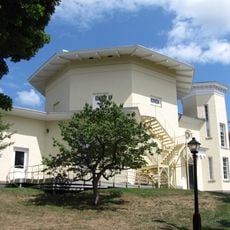
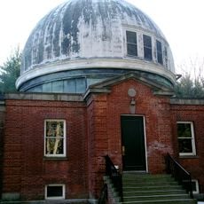
Post-Attack Command and Control System Facility, Hadley, Underground military bunker in Hadley, Massachusetts, United States

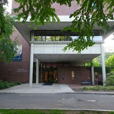
This facility is an underground repository with two levels that combines military fortification with advanced construction methods. The spaces offer controlled conditions and protect valuable academic collections from external elements.

The facility was built in 1957 as a command center for the Strategic Air Command and served the 8th Air Force until 1970. After its military deactivation, it was gradually adapted for civilian uses.

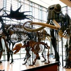
The site connects military history with academic purpose, housing collections from five colleges in its underground spaces today. This repurposing shows how Cold War sites were transformed to serve education.

The underground location offers consistent temperatures and conditions year-round, ideal for accessing large collections. Visitors should expect that navigating the facility requires planning, as it is not a public museum.

The Federal Reserve temporarily used this former military site to store currency reserves before it took on its academic function. This unexpected episode shows how the location served multiple national security purposes.

The community of curious travelers

AroundUs brings together thousands of curated places, local tips, and hidden gems, enriched daily by 60,000 contributors worldwide.

Start exploring
Location
Inception
1957
GPS coordinates
42.30420,-72.53510
Latest update
December 10, 2025 15:49
Around this place
Mount Holyoke
United States of America

Mount Holyoke

4.4 km
Eric Carle Museum of Picture Book Art
United States of America

Eric Carle Museum of Picture Book Art

1.9 km
Bare Mountain
United States of America

Bare Mountain

300 m
J. A. Skinner State Park
United States of America

J. A. Skinner State Park

4.4 km
Theodore Baird Residence
United States of America

Theodore Baird Residence

5.3 km
Mount Norwottuck
United States of America

Mount Norwottuck

2 km
Mead Art Museum
United States of America

Mead Art Museum

7.6 km
United States of America

Beer Can Museum

7.6 km
Mount Holyoke Range State Park
United States of America

Mount Holyoke Range State Park

1.9 km
Beneski Museum of Natural History, Amherst College
United States of America

Beneski Museum of Natural History, Amherst College

7.8 km
Calvin Coolidge Bridge
United States of America

Calvin Coolidge Bridge

7.7 km
Mount Nonotuck
United States of America

Mount Nonotuck

7.5 km
United States of America

Mount Hitchcock

855 m
Mount Holyoke College Art Museum
United States of America

Mount Holyoke College Art Museum

6.1 km
Long Mountain
United States of America

Long Mountain

4.5 km
Mount Holyoke College Botanic Garden
United States of America

Mount Holyoke College Botanic Garden

6 km
Goodwin Memorial African Methodist Episcopal Zion Church
United States of America

Goodwin Memorial African Methodist Episcopal Zion Church

7.5 km
The Octagon at Amherst College
United States of America

The Octagon at Amherst College

7.6 km
Hockanum Rural Historic District
United States of America

Hockanum Rural Historic District

5.2 km
Wilder Observatory
United States of America

Wilder Observatory

6.9 km
Woodbridge Street Historic District
United States of America

Woodbridge Street Historic District

5.4 km
Hadley Center Historic District
United States of America

Hadley Center Historic District

6.1 km
South Amherst Common Historic District
United States of America

South Amherst Common Historic District

4.8 km
Building at 8–22 Graves Avenue
United States of America

Building at 8–22 Graves Avenue

8 km
Shepherd and Damon Parsons Houses Historic District
United States of America

Shepherd and Damon Parsons Houses Historic District

7.8 km
Westside Historic District
United States of America

Westside Historic District

7 km
Pomeroy Terrace Historic District
United States of America

Pomeroy Terrace Historic District

7.8 km
Norwottuck Rail Trail Bridge
United States of America

Norwottuck Rail Trail Bridge

7.8 km
Show the full map
« Post-Attack Command and Control System Facility, Hadley - Underground military bunker in Hadley, Massachusetts, United States » is provided by Around Us (aroundus.com). Images and texts are derived from Wikimedia project under a Creative Commons license. You are allowed to copy, distribute, and modify copies of this page, under the conditions set by the license, as long as this note is clearly visible.

Discover hidden gems everywhere you go!

From secret cafés to breathtaking viewpoints, skip the crowded tourist spots and find places that match your style. Our app makes it easy with voice search, smart filtering, route optimization, and insider tips from travelers worldwide. Download now for the complete mobile experience.

Around Us App Screenshot

A unique approach to discovering new places

Le Figaro

All the places worth exploring

France Info

A tailor-made excursion in just a few clicks

20 Minutes

Around Us
Travel Guide & Maps
Download

Send to your phone

QR Code
1

Open the camera app on your mobile.

2

Point at the QR code with your camera. A notification will appear.

3

Tap the notification to open the link.