Ramsey County Poor Farm Barn

Log in to your account

AroundUs is a community-driven map of interesting places, built by curious explorers like you. It grows with every review, story, and photo you share.
Connect to save your favorite spots, contribute locations, and create personalized routes.
Continue with Google
Continue with Apple
Continue with X
Continue with Facebook
Continue with email
By continuing, you accept our Terms and Conditions and our Privacy Policy
Create an account
Add to collection
Map
Suggest a change
Share

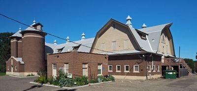
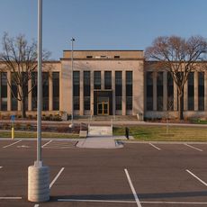
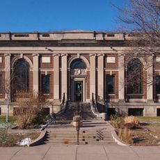
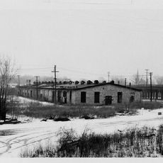
Ramsey County Poor Farm Barn, Registered historic brick barn in Maplewood, Minnesota.

The Ramsey County Poor Farm Barn is a two-story brick building located at the intersection of Frost Avenue and White Bear Avenue in Maplewood. Its lower level currently houses the Ramsey County Cooperative Extension Service, which uses the space for educational programs affiliated with the University of Minnesota.

Built in 1918 by architects Buechner & Orth, the barn was constructed as part of a government facility for poor residents. The structure was one of several buildings that formed an operation designed to be largely self-supporting through the labor of those who lived there.

The building was part of a facility where poor residents worked to earn their shelter, food, and clothing. This practice shapes how visitors understand the place's past and what questions it raises about care and community responsibility.

The brick exterior is easily visible from the street corner where it sits, making it simple to locate and photograph from the outside. Access to the interior depends on the Extension Service's program schedules, so it is best to plan a visit around these educational events.

An underground tunnel system beneath the barn once connected the various buildings of the complex. During the 1960s, someone managed to hide in these tunnels undetected for two years, a remarkable story of concealment within the larger institution.

Location: Saint Paul

Inception: 1918

GPS coordinates: 45.00028,-93.02417

Latest update: December 14, 2025 18:44

Photos
Around this place
Indian Mounds Park
United States of America

Indian Mounds Park

6.5 km
Minnesota Transportation Museum
United States of America

Minnesota Transportation Museum

7.1 km
Lowertown Historic District
United States of America

Lowertown Historic District

7.5 km
Cray Plaza
United States of America

Cray Plaza

7.6 km
St. Paul Minnesota Temple
United States of America

St. Paul Minnesota Temple

5.1 km
Gateway State Trail
United States of America

Gateway State Trail

4.5 km
Lafayette Bridge
United States of America

Lafayette Bridge

7.4 km
Seventh Street Improvement Arches
United States of America

Seventh Street Improvement Arches

6.4 km
3M Administration Building
United States of America

3M Administration Building

5 km
Bruce Vento Nature Sanctuary
United States of America

Bruce Vento Nature Sanctuary

6.6 km
Arlington Hills Library
United States of America

Arlington Hills Library

4.7 km
Church of St. Casimir
United States of America

Church of St. Casimir

4 km
Riverside Hangar
United States of America

Riverside Hangar

7.2 km
Saint Paul, Minneapolis, & Manitoba Railway Company Shops Historic District
United States of America

Saint Paul, Minneapolis, & Manitoba Railway Company Shops Historic District

7.3 km
Reservoir Woods Park
United States of America

Reservoir Woods Park

7.9 km
Benjamin Brunson House
United States of America

Benjamin Brunson House

6.5 km
Adolf Muench House
United States of America

Adolf Muench House

6.3 km
Finch, Vanslyck, and McConville Dry Goods Company Building
United States of America

Finch, Vanslyck, and McConville Dry Goods Company Building

7.5 km
Charles W. Schneider House
United States of America

Charles W. Schneider House

3.3 km
Euclid View Flats
United States of America

Euclid View Flats

6.1 km
Jacob Hinkel House
United States of America

Jacob Hinkel House

4.8 km
Giesen–Hauser House
United States of America

Giesen–Hauser House

6.2 km
Maplewood Area Historical Society
United States of America

Maplewood Area Historical Society

4.1 km
Minnesota Judicial Center
United States of America

Minnesota Judicial Center

7.8 km
Olaf Lee House
United States of America

Olaf Lee House

5.4 km
Sun Ray Branch Library
United States of America

Sun Ray Branch Library

5.2 km
Rice Street Branch Library
United States of America

Rice Street Branch Library

7.2 km
Indian Mounds Park Mound Group
United States of America

Indian Mounds Park Mound Group

6.6 km
Show the full map
Reviews

Visited this place? Tap the stars to rate it and share your experience / photos with the community! Try now! You can cancel it anytime.

« Ramsey County Poor Farm Barn - Registered historic brick barn in Maplewood, Minnesota » is provided by Around Us (aroundus.com). Images and texts are derived from Wikimedia project under a Creative Commons license. You are allowed to copy, distribute, and modify copies of this page, under the conditions set by the license, as long as this note is clearly visible.

Discover hidden gems everywhere you go!

From secret cafés to breathtaking viewpoints, skip the crowded tourist spots and find places that match your style. Our app makes it easy with voice search, smart filtering, route optimization, and insider tips from travelers worldwide. Download now for the complete mobile experience.

Around Us App Screenshot

A unique approach to discovering new places

Le Figaro

All the places worth exploring

France Info

A tailor-made excursion in just a few clicks

20 Minutes