Enable Location

We need your location to show you interesting places around you

Discover nearby places

Find interesting locations and hidden gems around you

Precise directions

Get accurate directions and distances to places

Your location is never shared with other users. It's only used when you tap the location button.

Reeds Gap State Park

Log in to your account

Start exploring — it's free

Trusted by 61,338 travelers worldwide

Continue with Google
Continue with Apple
or

We will send you a code to connect

By continuing, you accept our Terms and Conditions and our Privacy Policy

Check your inbox

We've sent a pincode in your inbox. Please enter the code below.

Reeds Gap State Park

Reeds Gap State Park, State park in New Lancaster Valley, Mifflin County, United States.

Description

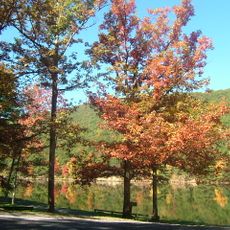
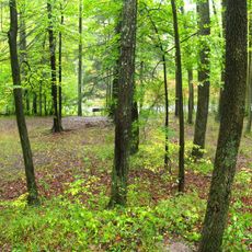
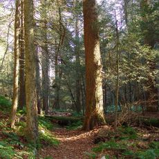
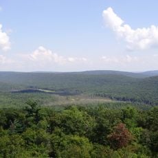
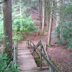
Reeds Gap State Park is a 220-acre forest reserve in a natural mountain pass in Pennsylvania's Mifflin County. Large hemlock and white pine trees shade the landscape, while Honey Creek winds through the terrain creating a cool, shaded corridor for visitors to explore.

History

This natural mountain pass served as a vital crossing point for Native American hunting parties and later became a gateway for colonial settlers moving through the valley. The region developed gradually from a transit route into a settlement area as families like the Reeds established themselves here.

Culture

The name comes from the Reed family who settled here in the 1700s and left their mark on the valley. Visitors walking the trails today can still sense the connection to those early pioneers who made this gap their home.

Practical

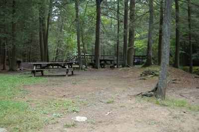
The park has two swimming areas, picnic spots scattered throughout the grounds, and multiple hiking trails of varying difficulty that follow the creek. Paths are generally well-marked and easy to navigate, even for families with younger children.

Did you know?

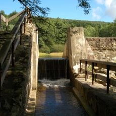
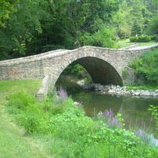
A water-powered sawmill once operated here by the Reed family, grinding timber from the surrounding forest. Hikers on the creek trail can spot remnants of the old dam structure that still directs water flow through the valley.

Location
Inception
1938
GPS coordinates
40.72170,-77.47530
Latest update
December 12, 2025 14:21

AroundUs brings together thousands of curated places, local tips, and hidden gems, enriched daily by 60,000 contributors worldwide. Discover all places nearby (Pennsylvania).

Around this place
Poe Valley State Park
United States of America

Poe Valley State Park

11.2 km
Poe Paddy State Park
United States of America

Poe Paddy State Park

13.4 km
Penn-Roosevelt State Park
United States of America

Penn-Roosevelt State Park

19.2 km
Fort Granville
United States of America

Fort Granville

18.3 km
Snyder Middleswarth Natural Area
United States of America

Snyder Middleswarth Natural Area

19 km
Bear Meadows Natural Area
United States of America

Bear Meadows Natural Area

24.4 km
Neff Round Barn
United States of America

Neff Round Barn

21.9 km
Academia Pomeroy Covered Bridge
United States of America

Academia Pomeroy Covered Bridge

25.4 km
Alan Seeger Natural Area
United States of America

Alan Seeger Natural Area

23.7 km
Old Stone Arch Bridge
United States of America

Old Stone Arch Bridge

16.7 km
Montgomery Ward Building
United States of America

Montgomery Ward Building

16 km
Embassy Theatre
United States of America

Embassy Theatre

16.2 km
Aaronsburg Historic District
United States of America

Aaronsburg Historic District

20 km
Mifflin County Courthouse
United States of America

Mifflin County Courthouse

16.2 km
Millheim Historic District
United States of America

Millheim Historic District

19 km
Maj. John Neff Homestead
United States of America

Maj. John Neff Homestead

24 km
Lehman's, Port Royal Covered Bridge
United States of America

Lehman's, Port Royal Covered Bridge

22.5 km
Centre Mills
United States of America

Centre Mills

22.7 km
Gross Covered Bridge
United States of America

Gross Covered Bridge

22.4 km
Rebersburg Historic District
United States of America

Rebersburg Historic District

24.9 km
Andrew Gregg Homestead
United States of America

Andrew Gregg Homestead

21.1 km
William Allison House
United States of America

William Allison House

17 km
Wollner Building
United States of America

Wollner Building

16 km
Maj. Jared B. Fisher House
United States of America

Maj. Jared B. Fisher House

17 km
Simon Pickle Stone House
United States of America

Simon Pickle Stone House

22.7 km
Miller Cinemas 6
United States of America

Miller Cinemas 6

16.3 km
McCoy House
United States of America

McCoy House

16.1 km
Linden Hall Historic District
United States of America

Linden Hall Historic District

25.6 km
Show the full map
« Reeds Gap State Park - State park in New Lancaster Valley, Mifflin County, United States » is provided by Around Us (aroundus.com). Images and texts are derived from Wikimedia project under a Creative Commons license. You are allowed to copy, distribute, and modify copies of this page, under the conditions set by the license, as long as this note is clearly visible.

Discover hidden gems everywhere you go!

From secret cafés to breathtaking viewpoints, skip the crowded tourist spots and find places that match your style. Our app makes it easy with voice search, smart filtering, route optimization, and insider tips from travelers worldwide. Download now for the complete mobile experience.

Around Us App Screenshot

A unique approach to discovering new places

Le Figaro

All the places worth exploring

France Info

A tailor-made excursion in just a few clicks

20 Minutes

Around Us
Travel Guide & Maps
Download

Send to your phone

QR Code
1

Open the camera app on your mobile.

2

Point at the QR code with your camera. A notification will appear.

3

Tap the notification to open the link.