Fort Granville

Log in to your account

AroundUs is a community-driven map of interesting places, built by curious explorers like you. It grows with every review, story, and photo you share.
Connect to save your favorite spots, contribute locations, and create personalized routes.
Continue with Google
Continue with Apple
Continue with X
Continue with Facebook
Continue with email
By continuing, you accept our Terms and Conditions and our Privacy Policy
Create an account
Add to collection
Map
Suggest a change
Share

Fort Granville, Colonial fort ruins near Lewistown, Pennsylvania, US.

Fort Granville was a fortification in Pennsylvania consisting of a square stockade with two blockhouses and barracks along the north bank of the Juniata River. The compound measured about 100 feet on each side and formed a defensive complex to protect nearby settlers.

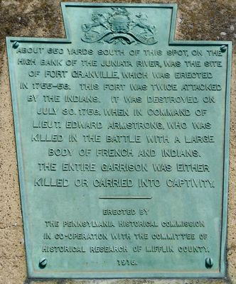
The fort was built in December 1755 by Pennsylvania Militia under Captain George Croghan to protect settlers during the French and Indian War. It was destroyed in August 1756 by French forces and their allies.

The site marked the boundary between colonial settlements and Native American lands, serving as a crucial part of frontier defense strategy. It shows how colonists attempted to establish control in contested territory.

A historical marker on 4th Street in Lewistown indicates where the fort once stood. Eight more historical markers nearby help visitors understand the wider regional history.

The 1756 attack resulted in the capture of soldiers and civilians, providing rare evidence of the violence that frontier conflicts inflicted on colonial outposts. This raid demonstrated how vulnerable these isolated positions truly were.

Location: Pennsylvania

GPS coordinates: 40.58830,-77.60160

Latest update: December 12, 2025 14:20

Photos
Around this place
Main Line of Public Works
United States of America

Main Line of Public Works

2.8 km
Port Royal Speedway
United States of America

Port Royal Speedway

18.9 km
Rothrock State Forest
United States of America

Rothrock State Forest

22.8 km
Greenwood Furnace State Park
United States of America

Greenwood Furnace State Park

15 km
Whipple Dam State Park
United States of America

Whipple Dam State Park

24.7 km
Standing Stone Trail
United States of America

Standing Stone Trail

15.4 km
Penn-Roosevelt State Park
United States of America

Penn-Roosevelt State Park

17.6 km
Reeds Gap State Park
United States of America

Reeds Gap State Park

18.3 km
Bear Meadows Natural Area
United States of America

Bear Meadows Natural Area

20.8 km
Neff Round Barn
United States of America

Neff Round Barn

26.9 km
Academia Pomeroy Covered Bridge
United States of America

Academia Pomeroy Covered Bridge

15.2 km
Alan Seeger Natural Area
United States of America

Alan Seeger Natural Area

17.4 km
Old Stone Arch Bridge
United States of America

Old Stone Arch Bridge

3.8 km
Montgomery Ward Building
United States of America

Montgomery Ward Building

2.6 km
Embassy Theatre
United States of America

Embassy Theatre

2.5 km
Saville Covered Bridge
United States of America

Saville Covered Bridge

24.1 km
Mifflin County Courthouse
United States of America

Mifflin County Courthouse

2.4 km
Kochendefer Covered Bridge
United States of America

Kochendefer Covered Bridge

25.7 km
Lehman's, Port Royal Covered Bridge
United States of America

Lehman's, Port Royal Covered Bridge

18.6 km
Boalsburg Historic District
United States of America

Boalsburg Historic District

26.5 km
Hill House
United States of America

Hill House

26.3 km
Wollner Building
United States of America

Wollner Building

2.6 km
Old Hoopes School
United States of America

Old Hoopes School

9.9 km
Kish park beach access
United States of America

Kish park beach access

5.5 km
Whipple Dam State Park Day Use District
United States of America

Whipple Dam State Park Day Use District

24.7 km
Miller Cinemas 6
United States of America

Miller Cinemas 6

2.4 km
McCoy House
United States of America

McCoy House

2.5 km
Linden Hall Historic District
United States of America

Linden Hall Historic District

26.9 km
Show the full map
Reviews

Visited this place? Tap the stars to rate it and share your experience / photos with the community! Try now! You can cancel it anytime.

« Fort Granville - Colonial fort ruins near Lewistown, Pennsylvania, US » is provided by Around Us (aroundus.com). Images and texts are derived from Wikimedia project under a Creative Commons license. You are allowed to copy, distribute, and modify copies of this page, under the conditions set by the license, as long as this note is clearly visible.

Discover hidden gems everywhere you go!

From secret cafés to breathtaking viewpoints, skip the crowded tourist spots and find places that match your style. Our app makes it easy with voice search, smart filtering, route optimization, and insider tips from travelers worldwide. Download now for the complete mobile experience.

Around Us App Screenshot

A unique approach to discovering new places

Le Figaro

All the places worth exploring

France Info

A tailor-made excursion in just a few clicks

20 Minutes