Enable Location

We need your location to show you interesting places around you

Discover nearby places

Find interesting locations and hidden gems around you

Precise directions

Get accurate directions and distances to places

Your location is never shared with other users. It's only used when you tap the location button.

Main Line of Public Works

Log in to your account

Start exploring — it's free

Trusted by 61,781 travelers worldwide

Continue with Google
Continue with Apple
or

We will send you a code to connect

By continuing, you accept our Terms and Conditions and our Privacy Policy

Check your inbox

We've sent a pincode in your inbox. Please enter the code below.

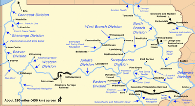
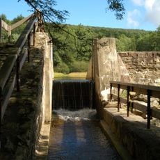
Main Line of Public Works, canal and transportation system in Pennsylvania

Description

The Main Line of Public Works is a canal network in Pennsylvania designed to move goods and materials across the state. The system includes waterways, aqueducts, and supporting structures that formed an integrated transportation route.

History

This canal system was built in the early 1800s to support Pennsylvania's economic growth and compete with other states. It represented a major advancement in transportation technology during the Industrial Revolution.

Practical

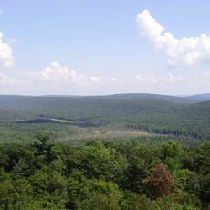
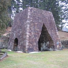
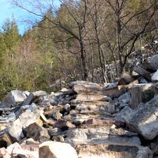
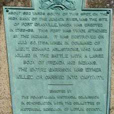
The remains of this system are scattered across Pennsylvania and can be explored on foot at various locations. Visitors can find surviving sections of the original canals and structures that give a sense of the historic route.

Did you know?

This system was one of the most ambitious transportation projects of its era, attempting to compete with the famous Erie Canal in New York. Though it did not achieve the same level of success as its northern rival, it left lasting marks on Pennsylvania's landscape.

Location
Part of
Pennsylvania Canal
GPS coordinates
40.59920,-77.57140
Latest update
December 15, 2025 13:27

AroundUs brings together thousands of curated places, local tips, and hidden gems, enriched daily by 60,000 contributors worldwide. Discover all places nearby (Pennsylvania).

Around this place
Port Royal Speedway
United States of America

Port Royal Speedway

16.9 km
Rothrock State Forest
United States of America

Rothrock State Forest

24.2 km
Greenwood Furnace State Park
United States of America

Greenwood Furnace State Park

16.9 km
Poe Valley State Park
United States of America

Poe Valley State Park

26.2 km
Whipple Dam State Park
United States of America

Whipple Dam State Park

26.5 km
Standing Stone Trail
United States of America

Standing Stone Trail

17.8 km
Penn-Roosevelt State Park
United States of America

Penn-Roosevelt State Park

18 km
Fort Granville
United States of America

Fort Granville

2.8 km
Reeds Gap State Park
United States of America

Reeds Gap State Park

15.9 km
Bear Meadows Natural Area
United States of America

Bear Meadows Natural Area

21.8 km
Neff Round Barn
United States of America

Neff Round Barn

26.7 km
Academia Pomeroy Covered Bridge
United States of America

Academia Pomeroy Covered Bridge

14.4 km
Alan Seeger Natural Area
United States of America

Alan Seeger Natural Area

18.6 km
Old Stone Arch Bridge
United States of America

Old Stone Arch Bridge

2.1 km
Montgomery Ward Building
United States of America

Montgomery Ward Building

210 m
Embassy Theatre
United States of America

Embassy Theatre

349 m
Saville Covered Bridge
United States of America

Saville Covered Bridge

23.3 km
Mifflin County Courthouse
United States of America

Mifflin County Courthouse

402 m
Kochendefer Covered Bridge
United States of America

Kochendefer Covered Bridge

24.9 km
Lehman's, Port Royal Covered Bridge
United States of America

Lehman's, Port Royal Covered Bridge

16.8 km
Boalsburg Historic District
United States of America

Boalsburg Historic District

27.2 km
Hill House
United States of America

Hill House

27 km
Wollner Building
United States of America

Wollner Building

210 m
Old Hoopes School
United States of America

Old Hoopes School

7.1 km
Kish park beach access
United States of America

Kish park beach access

3 km
Whipple Dam State Park Day Use District
United States of America

Whipple Dam State Park Day Use District

26.6 km
Miller Cinemas 6
United States of America

Miller Cinemas 6

440 m
McCoy House
United States of America

McCoy House

352 m
Show the full map
« Main Line of Public Works - canal and transportation system in Pennsylvania » is provided by Around Us (aroundus.com). Images and texts are derived from Wikimedia project under a Creative Commons license. You are allowed to copy, distribute, and modify copies of this page, under the conditions set by the license, as long as this note is clearly visible.

Discover hidden gems everywhere you go!

From secret cafés to breathtaking viewpoints, skip the crowded tourist spots and find places that match your style. Our app makes it easy with voice search, smart filtering, route optimization, and insider tips from travelers worldwide. Download now for the complete mobile experience.

Around Us App Screenshot

A unique approach to discovering new places

Le Figaro

All the places worth exploring

France Info

A tailor-made excursion in just a few clicks

20 Minutes

Around Us
Travel Guide & Maps
Download

Send to your phone

QR Code
1

Open the camera app on your mobile.

2

Point at the QR code with your camera. A notification will appear.

3

Tap the notification to open the link.