Enable Location

We need your location to show you interesting places around you

Discover nearby places

Find interesting locations and hidden gems around you

Precise directions

Get accurate directions and distances to places

Your location is never shared with other users. It's only used when you tap the location button.

Snyder Middleswarth Natural Area

Log in to your account

Start exploring — it's free

Trusted by 63,283 travelers worldwide

Continue with Google
Continue with Apple
or

We will send you a code to connect

By continuing, you accept our Terms and Conditions and our Privacy Policy

Check your inbox

We've sent a pincode in your inbox. Please enter the code below.

Snyder Middleswarth Natural Area
Discussion Reviews 1 Photos
2.5k Popularity

Snyder Middleswarth Natural Area, National Natural Landmark in Spring Township, Pennsylvania.

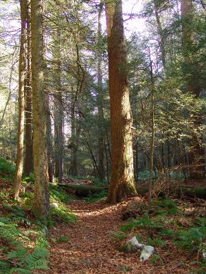
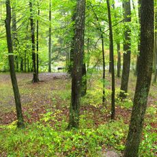
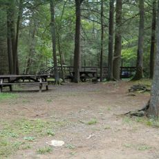
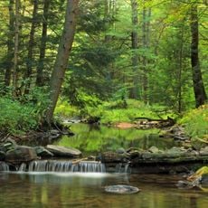
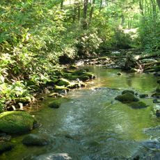
Snyder Middleswarth Natural Area is a protected forest containing hemlock, pine, and birch trees, with some reaching over 150 feet in height. The site spans roughly 500 acres and features multiple hiking trails including the Swift Run Trail and Hemlocks Trail, along with picnic areas near Rock Springs.

The land was acquired by the state in 1902 and established as Pennsylvania's ninth state park in 1921. It received its National Natural Landmark designation during the 1990s.

The site is named after Simon Snyder, a former Pennsylvania governor, and Ner Alexander Middleswarth, a state senator from Snyder County. These names honor two figures whose legacies are tied to this forest landscape.

The area is accessible via clearly marked trails suitable for different fitness levels. Parking and picnic areas are available, though visitors should be prepared for shaded and damp conditions, particularly after rain.

A fallen tree discovered within the protected area was found to be 347 years old. This finding reveals the true age of specimens in this forest and highlights its ecological value.

The community of curious travelers

AroundUs brings together thousands of curated places, local tips, and hidden gems, enriched daily by 60,000 contributors worldwide.

Start exploring
Location
GPS coordinates
40.81000,-77.28310
Latest update
December 8, 2025 21:08
Around this place
R. B. Winter State Park
United States of America

R. B. Winter State Park

22 km
Bald Eagle State Forest
United States of America

Bald Eagle State Forest

9.7 km
Poe Valley State Park
United States of America

Poe Valley State Park

16 km
Poe Paddy State Park
United States of America

Poe Paddy State Park

11.7 km
Reeds Gap State Park
United States of America

Reeds Gap State Park

19 km
McCalls Dam State Park
United States of America

McCalls Dam State Park

24.5 km
Sand Bridge State Park
United States of America

Sand Bridge State Park

25.3 km
Hassenplug Bridge
United States of America

Hassenplug Bridge

23.3 km
Hayes Bridge
United States of America

Hayes Bridge

20.6 km
Halfway Lake
United States of America

Halfway Lake

21.6 km
Aaronsburg Historic District
United States of America

Aaronsburg Historic District

17.5 km
Millmont Red Bridge
United States of America

Millmont Red Bridge

13.1 km
Logan Mills Covered Bridge
United States of America

Logan Mills Covered Bridge

23.4 km
Dreese's Covered Bridge
United States of America

Dreese's Covered Bridge

12.3 km
Millheim Historic District
United States of America

Millheim Historic District

18.8 km
Dimmsville Covered Bridge
United States of America

Dimmsville Covered Bridge

25.7 km
Centre Mills
United States of America

Centre Mills

20.5 km
New Berlin Presbyterian Church
United States of America

New Berlin Presbyterian Church

26.1 km
Gross Covered Bridge
United States of America

Gross Covered Bridge

9.2 km
Logan Mills Gristmill
United States of America

Logan Mills Gristmill

23.4 km
William A. Heiss House and Buggy Shop
United States of America

William A. Heiss House and Buggy Shop

22.9 km
Rebersburg Historic District
United States of America

Rebersburg Historic District

20.1 km
William Allison House
United States of America

William Allison House

25.6 km
Mifflinburg Historic District
United States of America

Mifflinburg Historic District

23 km
Fought's Mill
United States of America

Fought's Mill

24 km
Maj. Jared B. Fisher House
United States of America

Maj. Jared B. Fisher House

23.7 km
Old Hoopes School
United States of America

Old Hoopes School

26.7 km
Simon Pickle Stone House
United States of America

Simon Pickle Stone House

23.2 km
Show the full map
Reviews
Share your experience

No review yet

Discussions
Start a discussion...

No discussion yet

« Snyder Middleswarth Natural Area - National Natural Landmark in Spring Township, Pennsylvania » is provided by Around Us (aroundus.com). Images and texts are derived from Wikimedia project under a Creative Commons license. You are allowed to copy, distribute, and modify copies of this page, under the conditions set by the license, as long as this note is clearly visible.

Discover hidden gems everywhere you go!

From secret cafés to breathtaking viewpoints, skip the crowded tourist spots and find places that match your style. Our app makes it easy with voice search, smart filtering, route optimization, and insider tips from travelers worldwide. Download now for the complete mobile experience.

Around Us App Screenshot

A unique approach to discovering new places

Le Figaro

All the places worth exploring

France Info

A tailor-made excursion in just a few clicks

20 Minutes

Around Us
Travel Guide & Maps
Download

Send to your phone

QR Code
1

Open the camera app on your mobile.

2

Point at the QR code with your camera. A notification will appear.

3

Tap the notification to open the link.