Watts Bar Lake, Reservoir in Tennessee, United States
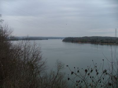
Watts Bar Lake is a reservoir in eastern Tennessee formed by the damming of a major river system. The shoreline alternates between shallow coves and wooded slopes, with numerous islands and narrow peninsulas extending into the water.
The Tennessee Valley Authority built the dam in the 1940s to generate electricity and reduce flood risk across the region. The impoundment created a large artificial body of water that reshaped the countryside between several small towns.
Boating and fishing bring families to the shore on weekends, with many setting up lakeside picnics or launching small watercraft for water sports. Local fishing clubs organize tournaments where participants share techniques and favorite spots along the water's edge.
Access is available from various shoreline roads, with public launch ramps located at several points for setting boats into the water. Conditions are generally calm during summer months, though water levels can fluctuate based on rainfall and dam operations.
The shoreline shifts between shallow areas dotted with submerged tree stumps and deeper sections that once were river valleys. In some coves, old foundations or bridge pilings emerge when water levels drop, remnants of settlements from before the dam was built.
The community of curious travelers
AroundUs brings together thousands of curated places, local tips, and hidden gems, enriched daily by 60,000 contributors worldwide.