Chest opened
+${chestReward.xp} XP
Explorer
NOUVEAU ×${chestReward.collectible.quantity}
tapez pour fermer
Chest locked

Open chests in the app

Around Us is built for your phone — chests unlock when you walk, explore and capture nearby places.

Enable Location

We need your location to show you interesting places around you

Discover nearby places

Find interesting locations and hidden gems around you

Precise directions

Get accurate directions and distances to places

Your location is never shared with other users. It's only used when you tap the location button.

Log in to your account

Start exploring — it's free

Trusted by 72,876 travelers worldwide

Continue with Google
Continue with Apple
or

We will send you a code to connect

By continuing, you accept our Terms and Conditions and our Privacy Policy

Check your inbox

We've sent a pincode in your inbox. Please enter the code below.

Rip Raps
Discussion Reviews Photo
12.1k Popularity

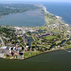
Rip Raps, Artificial island in Hampton Roads, Virginia.

Rip Raps is an artificial island in Hampton Roads, Virginia, home to Fort Wool, a fortified military structure. The island sits at the harbor entrance and functioned as a strategic defense point for maritime traffic.

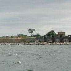
The island was built in 1817 by the United States Army Corps of Engineers to support the fort. It served as an active defense position during several military conflicts throughout the 19th and 20th centuries.

President Andrew Jackson selected this secluded island as his personal retreat, making regular visits between 1829 and 1835 during his presidency.

The island is visible from the shore and sits adjacent to the Hampton Roads Bridge-Tunnel, a major transportation corridor. Visitors can mainly view the island from the water or designated vantage points nearby.

Since 2020, the entire island has been a protected bird sanctuary with no public access allowed. The change was made to preserve natural migration patterns and seabird habitats.

The community of curious travelers

AroundUs brings together thousands of curated places, local tips, and hidden gems, enriched daily by 60,000 contributors worldwide.

Start exploring
GPS coordinates
36.98639,-76.30056
Latest update
December 7, 2025 20:46
Around this place
Fort Monroe
United States of America

Fort Monroe

2 km
Hampton Roads Bridge–Tunnel
United States of America

Hampton Roads Bridge–Tunnel

452 m
Emancipation Oak
United States of America

Emancipation Oak

4.9 km
Jamestown Exposition
United States of America

Jamestown Exposition

4.2 km
Fort Wool
United States of America

Fort Wool

0 m
The Chamberlin
United States of America

The Chamberlin

2 km
Thimble Shoal Light
United States of America

Thimble Shoal Light

6.2 km
Hampton National Cemetery
United States of America

Hampton National Cemetery

4.5 km
Armstrong Stadium
United States of America

Armstrong Stadium

4.8 km
Commodore Levy Chapel
United States of America

Commodore Levy Chapel

4.7 km
Virginia Air and Space Science Center
United States of America

Virginia Air and Space Science Center

5.7 km
Hampton Downtown Historic District
United States of America

Hampton Downtown Historic District

5.9 km
United States Navy Brig, Norfolk Virginia
United States of America

United States Navy Brig, Norfolk Virginia

6.3 km
Chapel of the Centurion
United States of America

Chapel of the Centurion

1.9 km
Victoria Boulevard Historic District
United States of America

Victoria Boulevard Historic District

5.6 km
Herbert House
United States of America

Herbert House

5.1 km
Buckroe Beach Carousel
United States of America

Buckroe Beach Carousel

5.7 km
Old Wythe Historic District
United States of America

Old Wythe Historic District

7.1 km
Hampton City Hall
United States of America

Hampton City Hall

5.9 km
Reuben Clark House
United States of America

Reuben Clark House

3.6 km
Hampton National Guard Armory
United States of America

Hampton National Guard Armory

6.4 km
Pasture Point Historic District
United States of America

Pasture Point Historic District

6.2 km
Scott House
United States of America

Scott House

6 km
William H. Trusty House
United States of America

William H. Trusty House

4.5 km
Old Point Comfort Light
United States of America

Old Point Comfort Light

1.8 km
American Theater
United States of America

American Theater

3.8 km
Salt Ponds Beach
United States of America

Salt Ponds Beach

8.3 km
Casemate Museum
United States of America

Casemate Museum

1.9 km
Show the full map
Reviews
Share your experience

No review yet

Discussions
Start a discussion...

No discussion yet

« Rip Raps - Artificial island in Hampton Roads, Virginia » is provided by Around Us (aroundus.com). Images and texts are derived from Wikimedia project under a Creative Commons license. You are allowed to copy, distribute, and modify copies of this page, under the conditions set by the license, as long as this note is clearly visible.

Discover hidden gems everywhere you go!

From secret cafés to breathtaking viewpoints, skip the crowded tourist spots and find places that match your style. Our app makes it easy with voice search, smart filtering, route optimization, and insider tips from travelers worldwide. Download now for the complete mobile experience.

Around Us App Screenshot

A unique approach to discovering new places

Le Figaro

All the places worth exploring

France Info

A tailor-made excursion in just a few clicks

20 Minutes

Around Us
Travel Guide & Maps
Download

Send to your phone

QR Code
1

Open the camera app on your mobile.

2

Point at the QR code with your camera. A notification will appear.

3

Tap the notification to open the link.