Saginaw River Rear Range Light

Log in to your account

AroundUs is a community-driven map of interesting places, built by curious explorers like you. It grows with every review, story, and photo you share.
Connect to save your favorite spots, contribute locations, and create personalized routes.
Continue with Google
Continue with Apple
Continue with X
Continue with Facebook
Continue with email
By continuing, you accept our Terms and Conditions and our Privacy Policy
Create an account
Add to collection
Map
Suggest a change
Share

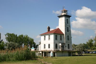
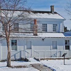
Saginaw River Rear Range Light, Maritime lighthouse in Bay County, United States.

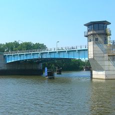
The Saginaw River Rear Range Light is a brick structure standing about 53 feet tall with an attached two-story residence containing a kitchen, parlor, and three bedrooms connected by a cast iron spiral staircase to an octagonal lantern room. The building was designed with fire safety in mind, including heavy iron doors between floors and an oil storage room on the lower level.

Built in 1876 as part of a range light system, the structure was constructed to guide ships after engineers dredged the Saginaw River channel in 1867. It represents investments made to support navigation during the height of the timber trade era in the region.

The lighthouse embodies the maritime and lumber trade traditions that shaped the region's growth along the waterway. Visitors can see how such structures marked important passages for commerce and settlement during the industrial era.

The sturdy brick construction with tight door seals between levels provides good structural integrity for exploration. Visitors should expect narrow stairs and limited headroom in certain areas, particularly when climbing to the lantern room.

The foundation required timber piles driven deep into swampy ground to support a heavy concrete base and brick walls. This approach reveals how 19th-century builders solved engineering challenges posed by wet, unstable soil.

Location: Bay County

Inception: 1839

Architects: Godfrey Weitzel

Made from material: brick

GPS coordinates: 43.63556,-83.85028

Latest update: December 13, 2025 12:22

Photos
Around this place
Zilwaukee Bridge
United States of America

Zilwaukee Bridge

17.8 km
USS Edson
United States of America

USS Edson

2.8 km
Dow Event Center
United States of America

Dow Event Center

23.3 km
Hoyt Library
United States of America

Hoyt Library

23.9 km
Castle Museum
United States of America

Castle Museum

23.8 km
Tobico Marsh
United States of America

Tobico Marsh

9.8 km
Veterans Memorial Bridge
United States of America

Veterans Memorial Bridge

5.6 km
Temple Theatre
United States of America

Temple Theatre

23.5 km
Cathedral of Mary of the Assumption
United States of America

Cathedral of Mary of the Assumption

24.4 km
Lafayette Avenue Bridge
United States of America

Lafayette Avenue Bridge

7.4 km
Marshall M. Fredericks Sculpture Museum
United States of America

Marshall M. Fredericks Sculpture Museum

16.3 km
Bay City State Park
United States of America

Bay City State Park

5.6 km
City Hall
United States of America

City Hall

5.6 km
Sage Library
United States of America

Sage Library

5.8 km
Bay City Downtown Historic District
United States of America

Bay City Downtown Historic District

5 km
Mercy Hospital and Elizabeth McDowell Bialy Memorial House
United States of America

Mercy Hospital and Elizabeth McDowell Bialy Memorial House

6.5 km
Trombley House
United States of America

Trombley House

6.4 km
Bay City Masonic Temple
United States of America

Bay City Masonic Temple

5.1 km
Veterans Memorial Park
United States of America

Veterans Memorial Park

5.7 km
Fletcher Site
United States of America

Fletcher Site

4.5 km
Midland Street Commercial District
United States of America

Midland Street Commercial District

5.5 km
Michigan Bell Building
United States of America

Michigan Bell Building

23.9 km
Odd Fellows Valley Lodge No. 189 Building
United States of America

Odd Fellows Valley Lodge No. 189 Building

8.1 km
Bay County Building
United States of America

Bay County Building

5 km
House at 1514 N. Michigan Street
United States of America

House at 1514 N. Michigan Street

24.3 km
East Genesee Historic Business District
United States of America

East Genesee Historic Business District

23.8 km
Independence Bridge
United States of America

Independence Bridge

3.1 km
Liberty Bridge
United States of America

Liberty Bridge

4.7 km
Show the full map
Reviews

Visited this place? Tap the stars to rate it and share your experience / photos with the community! Try now! You can cancel it anytime.

« Saginaw River Rear Range Light - Maritime lighthouse in Bay County, United States » is provided by Around Us (aroundus.com). Images and texts are derived from Wikimedia project under a Creative Commons license. You are allowed to copy, distribute, and modify copies of this page, under the conditions set by the license, as long as this note is clearly visible.

Discover hidden gems everywhere you go!

From secret cafés to breathtaking viewpoints, skip the crowded tourist spots and find places that match your style. Our app makes it easy with voice search, smart filtering, route optimization, and insider tips from travelers worldwide. Download now for the complete mobile experience.

Around Us App Screenshot

A unique approach to discovering new places

Le Figaro

All the places worth exploring

France Info

A tailor-made excursion in just a few clicks

20 Minutes