Enable Location

We need your location to show you interesting places around you

Discover nearby places

Find interesting locations and hidden gems around you

Precise directions

Get accurate directions and distances to places

Your location is never shared with other users. It's only used when you tap the location button.

Schuylkill River Bridge

Log in to your account

Start exploring — it's free

Trusted by 61,864 travelers worldwide

Continue with Google
Continue with Apple
or

We will send you a code to connect

By continuing, you accept our Terms and Conditions and our Privacy Policy

Check your inbox

We've sent a pincode in your inbox. Please enter the code below.

Schuylkill River Bridge

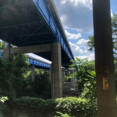
Schuylkill River Bridge, Road bridge across Schuylkill River in Montgomery County, Pennsylvania

Description

The Schuylkill River Bridge is a road bridge carrying Interstate 276 Pennsylvania Turnpike across the waterway, connecting the Swedesburg and Black Horse communities. The structure spans approximately 1,224 feet and handles traffic flowing between Philadelphia and surrounding areas.

History

The bridge was originally built in 1954 as a four-lane connection and has shaped regional infrastructure since then. During the 1990s, it was enlarged and modernized to keep pace with growing traffic demands.

Culture

The bridge joins two communities and enables daily movement between people from different areas. It shapes the landscape and serves as a familiar landmark for many who travel through the region regularly.

Practical

The bridge is accessible in both directions and offers good sight lines, especially during daylight travel. Be aware that traffic becomes heavier during morning and evening rush periods.

Did you know?

The structure was partially redesigned during its 1990s expansion to incorporate feedback from nearby residents. This collaboration led to design improvements that positively affected the driving experience.

Location
GPS coordinates
40.10310,-75.32500
Latest update
December 14, 2025 12:26

AroundUs brings together thousands of curated places, local tips, and hidden gems, enriched daily by 60,000 contributors worldwide. Discover all places nearby (Pennsylvania).

Around this place
Woodmont
United States of America

Woodmont

4.8 km
Elmwood Park Zoo
United States of America

Elmwood Park Zoo

3.5 km
Hovenden House, Barn and Abolition Hall
United States of America

Hovenden House, Barn and Abolition Hall

4 km
La Ronda
United States of America

La Ronda

6.2 km
Erdenheim Farm
United States of America

Erdenheim Farm

7.5 km
St. Thomas of Villanova Church
United States of America

St. Thomas of Villanova Church

7.4 km
Selma Mansion
United States of America

Selma Mansion

3.7 km
Norristown Farm Park
United States of America

Norristown Farm Park

4 km
Barbadoes Island
United States of America

Barbadoes Island

2.9 km
Harriton House
United States of America

Harriton House

7.7 km
Woodcrest
United States of America

Woodcrest

7.1 km
Plymouth Meeting Historic District
United States of America

Plymouth Meeting Historic District

4.2 km
Arboretum Villanova
United States of America

Arboretum Villanova

7.5 km
Plymouth Friends Meetinghouse
United States of America

Plymouth Friends Meetinghouse

3.8 km
St. George Coptic Orthodox Church
United States of America

St. George Coptic Orthodox Church

1.9 km
Old Norriton Presbyterian Church
United States of America

Old Norriton Presbyterian Church

7.4 km
Fayette Street Bridge
United States of America

Fayette Street Bridge

3.8 km
Bridge in Upper Merion Township
United States of America

Bridge in Upper Merion Township

4 km
Mount Joy
United States of America

Mount Joy

4.4 km
Central Norristown Historic District
United States of America

Central Norristown Historic District

2 km
Cold Point Historic District
United States of America

Cold Point Historic District

5 km
Appleford/Parsons-Banks Arboretum
United States of America

Appleford/Parsons-Banks Arboretum

5.6 km
Miller's House at Spring Mill
United States of America

Miller's House at Spring Mill

4.5 km
Alan West Corson Homestead
United States of America

Alan West Corson Homestead

5.3 km
Poplar Lane
United States of America

Poplar Lane

3.8 km
Globe Knitting Mills
United States of America

Globe Knitting Mills

1.1 km
Pearl Harbor Memorial Bridge
United States of America

Pearl Harbor Memorial Bridge

2.8 km
West Norristown Historic District
United States of America

West Norristown Historic District

3.1 km
Show the full map
« Schuylkill River Bridge - Road bridge across Schuylkill River in Montgomery County, Pennsylvania » is provided by Around Us (aroundus.com). Images and texts are derived from Wikimedia project under a Creative Commons license. You are allowed to copy, distribute, and modify copies of this page, under the conditions set by the license, as long as this note is clearly visible.

Discover hidden gems everywhere you go!

From secret cafés to breathtaking viewpoints, skip the crowded tourist spots and find places that match your style. Our app makes it easy with voice search, smart filtering, route optimization, and insider tips from travelers worldwide. Download now for the complete mobile experience.

Around Us App Screenshot

A unique approach to discovering new places

Le Figaro

All the places worth exploring

France Info

A tailor-made excursion in just a few clicks

20 Minutes

Around Us
Travel Guide & Maps
Download

Send to your phone

QR Code
1

Open the camera app on your mobile.

2

Point at the QR code with your camera. A notification will appear.

3

Tap the notification to open the link.