Enable Location

We need your location to show you interesting places around you

Discover nearby places

Find interesting locations and hidden gems around you

Precise directions

Get accurate directions and distances to places

Your location is never shared with other users. It's only used when you tap the location button.

Schaefer Head

Log in to your account

Start exploring — it's free

Trusted by 61,363 travelers worldwide

Continue with Google
Continue with Apple
or

We will send you a code to connect

By continuing, you accept our Terms and Conditions and our Privacy Policy

Check your inbox

We've sent a pincode in your inbox. Please enter the code below.

Schaefer Head

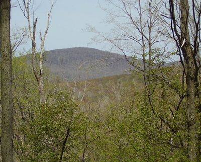
Schaefer Head, Mountain summit in Blair County, Pennsylvania, US.

Description

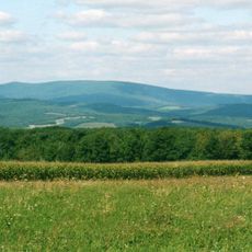
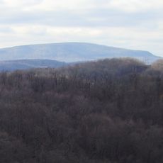
Schaefer Head is a mountain summit in the Allegheny Mountains within Blair County, Pennsylvania. The peak has a cone-shaped profile and forms part of the larger Blue Knob mountain range in this area.

History

The mountain formed through geological processes that separated the Blue Knob massif from the Allegheny Front. These tectonic changes shaped the mountain landscape visible in this region of Pennsylvania's Appalachian range.

Culture

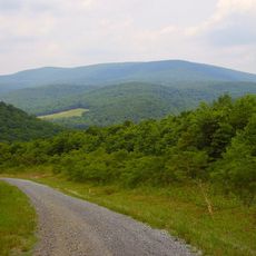
This peak represents a natural landmark for mountaineers who seek to reach the highest points across Pennsylvania's diverse topography.

Practical

Reaching the summit requires strong navigation skills and determination, as no marked trails exist. Visitors should expect dense vegetation and demanding terrain throughout the approach.

Did you know?

This peak ranks as the highest point in Blair County and the third highest in the Blue Knob massif. This distinction makes it a notable goal for those seeking to reach the county's top elevation.

Location
GPS coordinates
40.32230,-78.55946
Latest update
December 14, 2025 17:43

AroundUs brings together thousands of curated places, local tips, and hidden gems, enriched daily by 60,000 contributors worldwide. Discover all places nearby (Pennsylvania).

Around this place
Horseshoe Curve
United States of America

Horseshoe Curve

20.5 km
Leap-The-Dips
United States of America

Leap-The-Dips

21.5 km
Allegheny Portage Railroad
United States of America

Allegheny Portage Railroad

14.8 km
Johnstown Flood National Memorial
United States of America

Johnstown Flood National Memorial

18.8 km
Blue Knob
United States of America

Blue Knob

3.8 km
Blue Knob State Park
United States of America

Blue Knob State Park

5.2 km
DeGol Field
United States of America

DeGol Field

21.5 km
Highland Hall
United States of America

Highland Hall

18.7 km
John P. Saylor Trail
United States of America

John P. Saylor Trail

20.2 km
Blair County Courthouse
United States of America

Blair County Courthouse

18.6 km
Ritchey Knob
United States of America

Ritchey Knob

4.2 km
Pine Knob
United States of America

Pine Knob

3.9 km
Hollidaysburg Historic District
United States of America

Hollidaysburg Historic District

18.6 km
Dr. Knisley Covered Bridge
United States of America

Dr. Knisley Covered Bridge

18.4 km
Benjamin Franklin Jones Cottage
United States of America

Benjamin Franklin Jones Cottage

15.3 km
Ryot Covered Bridge
United States of America

Ryot Covered Bridge

20.8 km
Bridge in Portage Township
United States of America

Bridge in Portage Township

11.2 km
Snooks Covered Bridge
United States of America

Snooks Covered Bridge

17.1 km
Osterburg Covered Bridge
United States of America

Osterburg Covered Bridge

16.3 km
Johnstown Flood National Memorial
United States of America

Johnstown Flood National Memorial

18.2 km
Roaring Spring Historic District
United States of America

Roaring Spring Historic District

13.7 km
New Enterprise Public School
United States of America

New Enterprise Public School

21.2 km
Portage Historic District
United States of America

Portage Historic District

11.9 km
Unger House
United States of America

Unger House

18.2 km
South Fork Fishing and Hunting Club Clubhouse
United States of America

South Fork Fishing and Hunting Club Clubhouse

18.1 km
Gallitzin Tunnels
United States of America

Gallitzin Tunnels

17.7 km
Lilly Bridge
United States of America

Lilly Bridge

12.4 km
Lake View Visitor Center
United States of America

Lake View Visitor Center

18.2 km
Show the full map
« Schaefer Head - Mountain summit in Blair County, Pennsylvania, US » is provided by Around Us (aroundus.com). Images and texts are derived from Wikimedia project under a Creative Commons license. You are allowed to copy, distribute, and modify copies of this page, under the conditions set by the license, as long as this note is clearly visible.

Discover hidden gems everywhere you go!

From secret cafés to breathtaking viewpoints, skip the crowded tourist spots and find places that match your style. Our app makes it easy with voice search, smart filtering, route optimization, and insider tips from travelers worldwide. Download now for the complete mobile experience.

Around Us App Screenshot

A unique approach to discovering new places

Le Figaro

All the places worth exploring

France Info

A tailor-made excursion in just a few clicks

20 Minutes

Around Us
Travel Guide & Maps
Download

Send to your phone

QR Code
1

Open the camera app on your mobile.

2

Point at the QR code with your camera. A notification will appear.

3

Tap the notification to open the link.