Enable Location

We need your location to show you interesting places around you

Discover nearby places

Find interesting locations and hidden gems around you

Precise directions

Get accurate directions and distances to places

Your location is never shared with other users. It's only used when you tap the location button.

Shaupeneak Ridge Cooperative Recreation Area

Log in to your account

Start exploring — it's free

Trusted by 62,442 travelers worldwide

Continue with Google
Continue with Apple
or

We will send you a code to connect

By continuing, you accept our Terms and Conditions and our Privacy Policy

Check your inbox

We've sent a pincode in your inbox. Please enter the code below.

Shaupeneak Ridge Cooperative Recreation Area

Shaupeneak Ridge Cooperative Recreation Area, park in New York, United States of America

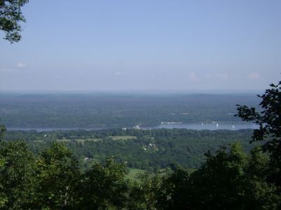
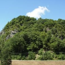
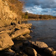
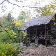
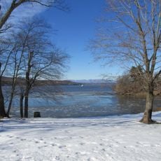
The Shaupeneak Ridge Cooperative Recreation Area is a park covering over 900 acres in New York with wildflower fields, woods, a waterfall, a pond, and rock formations. The landscape extends to the Hudson River and Catskill Mountains, visible when leaves fall from the trees.

The land shows the area's past through old stone walls that tell of earlier use and settlement. The park was established through partnership between the New York State Department of Environmental Conservation and the West Esopus Landowners Association to preserve this place for everyone.

The Sojourner Truth Trail honors a civil rights and women's rights activist whose story unfolds along the path. Walking here connects visitors to her legacy of justice and equality.

Two parking areas serve the park, one upper lot off Old Post Road and a lower one providing waterfall access. Trails are marked with colors and walks range from about two hours for shorter loops to several hours for complete explorations.

A memorial with a large cross honors Derek Wood, a young man who died in a collision on Route 9W. The waterfall was his favorite place, making this spot one of remembrance and reflection.

The community of curious travelers

AroundUs brings together thousands of curated places, local tips, and hidden gems, enriched daily by 60,000 contributors worldwide.

Start exploring
Location
Inception
1994
GPS coordinates
41.83720,-73.99440
Latest update
February 9, 2026 11:07
Around this place
Staatsburgh State Historic Site
United States of America

Staatsburgh State Historic Site

5.8 km
Wyndcliffe
United States of America

Wyndcliffe

7.4 km
Wilderstein
United States of America

Wilderstein

7.7 km
Col. Oliver Hazard Payne Estate
United States of America

Col. Oliver Hazard Payne Estate

4.2 km
Joppenbergh Mountain
United States of America

Joppenbergh Mountain

7.7 km
United States of America

Locusts on Hudson

6.3 km
Perrine's Bridge
United States of America

Perrine's Bridge

5.5 km
Holy Cross Monastery
United States of America

Holy Cross Monastery

4.9 km
Margaret Lewis Norrie State Park
United States of America

Margaret Lewis Norrie State Park

6.4 km
Slabsides
United States of America

Slabsides

5.1 km
St. James Episcopal Church
United States of America

St. James Episcopal Church

6.2 km
Vanderbilt Mansion
United States of America

Vanderbilt Mansion

6.3 km
Rosendale Theatre
United States of America

Rosendale Theatre

7.3 km
Esopus Meadows Light
United States of America

Esopus Meadows Light

5.6 km
Wales House
United States of America

Wales House

6.8 km
St. James Chapel
United States of America

St. James Chapel

7.1 km
Langdon Estate Gatehouse
United States of America

Langdon Estate Gatehouse

7 km
John Hendricks House and Dutch Barn
United States of America

John Hendricks House and Dutch Barn

5.4 km
George Rymph House
United States of America

George Rymph House

5.1 km
Rosendale Library
United States of America

Rosendale Library

6.8 km
Vanderbilt Lane Historic District
United States of America

Vanderbilt Lane Historic District

6.2 km
Reformed Protestant Dutch Church of Klyne Esopus
United States of America

Reformed Protestant Dutch Church of Klyne Esopus

2.8 km
Poppletown Farmhouse
United States of America

Poppletown Farmhouse

2.4 km
Main Street-Albertson Street-Park Place Historic District
United States of America

Main Street-Albertson Street-Park Place Historic District

7.1 km
Staatsburgh State Historic Site
United States of America

Staatsburgh State Historic Site

5.8 km
Wilderstein
United States of America

Wilderstein

7.7 km
Ogden Mills & Ruth Livingston Mills State Park
United States of America

Ogden Mills & Ruth Livingston Mills State Park

5.7 km
Hyde Park Station
United States of America

Hyde Park Station

6.8 km
Show the full map
« Shaupeneak Ridge Cooperative Recreation Area - park in New York, United States of America » is provided by Around Us (aroundus.com). Images and texts are derived from Wikimedia project under a Creative Commons license. You are allowed to copy, distribute, and modify copies of this page, under the conditions set by the license, as long as this note is clearly visible.

Discover hidden gems everywhere you go!

From secret cafés to breathtaking viewpoints, skip the crowded tourist spots and find places that match your style. Our app makes it easy with voice search, smart filtering, route optimization, and insider tips from travelers worldwide. Download now for the complete mobile experience.

Around Us App Screenshot

A unique approach to discovering new places

Le Figaro

All the places worth exploring

France Info

A tailor-made excursion in just a few clicks

20 Minutes

Around Us
Travel Guide & Maps
Download

Send to your phone

QR Code
1

Open the camera app on your mobile.

2

Point at the QR code with your camera. A notification will appear.

3

Tap the notification to open the link.