Enable Location

We need your location to show you interesting places around you

Discover nearby places

Find interesting locations and hidden gems around you

Precise directions

Get accurate directions and distances to places

Your location is never shared with other users. It's only used when you tap the location button.

Shiloh Temple

Log in to your account

Start exploring — it's free

Trusted by 62,903 travelers worldwide

Continue with Google
Continue with Apple
or

We will send you a code to connect

By continuing, you accept our Terms and Conditions and our Privacy Policy

Check your inbox

We've sent a pincode in your inbox. Please enter the code below.

Discussion Reviews 1 Photos
3.4k Popularity

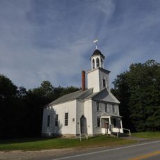
Shiloh Temple, Religious site in Durham, Maine, United States

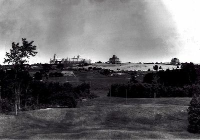
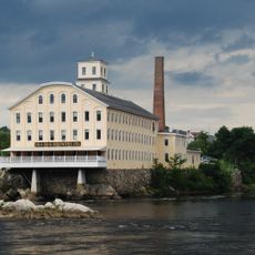
Shiloh Temple is a four-story brick building in Durham featuring a distinctive seven-stage square tower crowned with a circular belfry overlooking the Androscoggin River. The structure displays the classical architectural styling typical of the late 1800s and early 1900s period.

Baptist minister Frank Sandford established the complex in 1897 as a religious community that grew to house over 1000 residents in its early years. The site was later recognized for its place in American religious history and listed on the National Register of Historic Places in 1975.

The temple embodies the ideals of early evangelical communal living, where believers resided and worked together under one spiritual vision. Visitors can observe how the structure was designed to support this shared daily life, though the original community has long since dispersed.

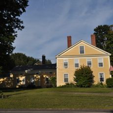
The building stands on Beulah Lane and now operates as Shiloh Chapel, an independent evangelical church open to visitors and the local community. Plan to spend time observing the detailed architectural features both outside and inside the structure.

The original complex was vastly larger than the building standing today, encompassing over 500 rooms where the community operated its own print shop, cobbler shop, and working farm. The agricultural operation was remarkably productive, supplying the large population with essential food items.

The community of curious travelers

AroundUs brings together thousands of curated places, local tips, and hidden gems, enriched daily by 60,000 contributors worldwide.

Start exploring
Location
GPS coordinates
43.98028,-70.04722
Latest update
December 12, 2025 08:01
Around this place
Frank J. Wood Bridge
United States of America

Frank J. Wood Bridge

9.3 km
Fort Andross
United States of America

Fort Andross

9.6 km
Brunswick Falls
United States of America

Brunswick Falls

9.2 km
Androscoggin Swinging Bridge
United States of America

Androscoggin Swinging Bridge

9.1 km
Bangor Air Defense Sector
United States of America

Bangor Air Defense Sector

7.8 km
Worumbo Mill
United States of America

Worumbo Mill

2.2 km
Curtis Memorial Library
United States of America

Curtis Memorial Library

9.9 km
Fort George
United States of America

Fort George

9.6 km
Pejepscot Paper Company
United States of America

Pejepscot Paper Company

9.3 km
Richardson House
United States of America

Richardson House

9.8 km
Bagley-Bliss House
United States of America

Bagley-Bliss House

6.9 km
Skolfield-Whittier House
United States of America

Skolfield-Whittier House

10 km
St. Paul's Episcopal Church
United States of America

St. Paul's Episcopal Church

9.8 km
Growstown School
United States of America

Growstown School

9.8 km
John Dunlap House
United States of America

John Dunlap House

9.4 km
West Durham Methodist Church
United States of America

West Durham Methodist Church

8.9 km
St. Cyril and St. Methodius Church
United States of America

St. Cyril and St. Methodius Church

2.3 km
Cushman Tavern
United States of America

Cushman Tavern

9.4 km
Farwell Mill
United States of America

Farwell Mill

7.3 km
Historic district in Maine, United States
United States of America

Historic district in Maine, United States

9.7 km
Union Church
United States of America

Union Church

6.6 km
Lincoln Street Historic District
United States of America

Lincoln Street Historic District

9.5 km
Topsham Historic District
United States of America

Topsham Historic District

9.1 km
Cathance Water Tower
United States of America

Cathance Water Tower

9.9 km
Topsham Fairgrounds Grandstand
United States of America

Topsham Fairgrounds Grandstand

9.6 km
Maine State Music Theatre
United States of America

Maine State Music Theatre

10 km
Nathaniel Osgood House
United States of America

Nathaniel Osgood House

7.5 km
Free-Black Bridge
United States of America

Free-Black Bridge

9.2 km
Show the full map
Reviews
Share your experience

No review yet

Discussions
Start a discussion...

No discussion yet

« Shiloh Temple - Religious site in Durham, Maine, United States » is provided by Around Us (aroundus.com). Images and texts are derived from Wikimedia project under a Creative Commons license. You are allowed to copy, distribute, and modify copies of this page, under the conditions set by the license, as long as this note is clearly visible.

Discover hidden gems everywhere you go!

From secret cafés to breathtaking viewpoints, skip the crowded tourist spots and find places that match your style. Our app makes it easy with voice search, smart filtering, route optimization, and insider tips from travelers worldwide. Download now for the complete mobile experience.

Around Us App Screenshot

A unique approach to discovering new places

Le Figaro

All the places worth exploring

France Info

A tailor-made excursion in just a few clicks

20 Minutes

Around Us
Travel Guide & Maps
Download

Send to your phone

QR Code
1

Open the camera app on your mobile.

2

Point at the QR code with your camera. A notification will appear.

3

Tap the notification to open the link.