Enable Location

We need your location to show you interesting places around you

Discover nearby places

Find interesting locations and hidden gems around you

Precise directions

Get accurate directions and distances to places

Your location is never shared with other users. It's only used when you tap the location button.

Fort Andross

Log in to your account

Start exploring — it's free

Trusted by 62,903 travelers worldwide

Continue with Google
Continue with Apple
or

We will send you a code to connect

By continuing, you accept our Terms and Conditions and our Privacy Policy

Check your inbox

We've sent a pincode in your inbox. Please enter the code below.

Discussion Reviews 1 Photos
4.5k Popularity

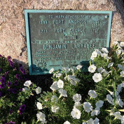
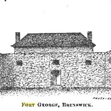
Fort Andross, Military fortification in Brunswick, Maine, United States

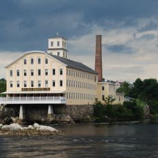
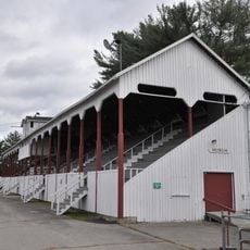
Fort Andross is a fortification built with wood and stone that stands on the banks of the Androscoggin River in Brunswick and dates from the late 1600s. Today the building functions as a commercial center with offices, shops, and spaces for community events.

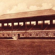
The fort was established in 1688 under Governor Edmund Andros to protect settlements from attacks during colonial conflicts. In the 1800s it was converted into a cotton mill, marking the shift from military purpose to industrial manufacturing that defined New England's development.

The building reflects how New England shifted from military defense to factory production, and visitors today can see this transformation through the different spaces within the structure. The transition shaped how communities here developed and what work meant to generations of people living nearby.

The building sits along the river and is easy to reach from Brunswick's downtown area. Visitors should know that much of the space is occupied by offices and shops with their own separate hours and operations.

A mural titled 'Many Stitches Hold Up the Sky' covers the south side of the structure and depicts eight distinct cultural groups from the area. This artwork adds a contemporary layer to a site otherwise anchored in the past.

The community of curious travelers

AroundUs brings together thousands of curated places, local tips, and hidden gems, enriched daily by 60,000 contributors worldwide.

Start exploring
Location
Location
Inception
1688
Made from material
wood, stone
Part of
Dominion of New England
Address
14 Maine Street
GPS coordinates
43.91669,-69.96611
Latest update
December 10, 2025 20:09
Around this place
Frank J. Wood Bridge
United States of America

Frank J. Wood Bridge

492 m
Joshua L. Chamberlain Museum
United States of America

Joshua L. Chamberlain Museum

725 m
Harriet Beecher Stowe House
United States of America

Harriet Beecher Stowe House

608 m
Bowdoin College Museum of Art
United States of America

Bowdoin College Museum of Art

961 m
Brunswick Falls
United States of America

Brunswick Falls

501 m
Androscoggin Swinging Bridge
United States of America

Androscoggin Swinging Bridge

650 m
Bangor Air Defense Sector
United States of America

Bangor Air Defense Sector

3.2 km
Peary–MacMillan Arctic Museum
United States of America

Peary–MacMillan Arctic Museum

1 km
First Parish Church
United States of America

First Parish Church

726 m
Whittier Field
United States of America

Whittier Field

1.3 km
Curtis Memorial Library
United States of America

Curtis Memorial Library

420 m
Massachusetts Hall
United States of America

Massachusetts Hall

836 m
Fort George
United States of America

Fort George

1 m
Pejepscot Paper Company
United States of America

Pejepscot Paper Company

565 m
Parker Cleaveland House
United States of America

Parker Cleaveland House

848 m
Henry Boody House
United States of America

Henry Boody House

1.1 km
Richardson House
United States of America

Richardson House

641 m
Skolfield-Whittier House
United States of America

Skolfield-Whittier House

366 m
St. Paul's Episcopal Church
United States of America

St. Paul's Episcopal Church

387 m
John Dunlap House
United States of America

John Dunlap House

230 m
Federal Street Historic District
United States of America

Federal Street Historic District

549 m
Historic district in Maine, United States
United States of America

Historic district in Maine, United States

106 m
Lincoln Street Historic District
United States of America

Lincoln Street Historic District

111 m
Topsham Historic District
United States of America

Topsham Historic District

1.2 km
Topsham Fairgrounds Grandstand
United States of America

Topsham Fairgrounds Grandstand

1.6 km
Maine State Music Theatre
United States of America

Maine State Music Theatre

456 m
Pickard Theater
United States of America

Pickard Theater

812 m
Free-Black Bridge
United States of America

Free-Black Bridge

733 m
Show the full map
Reviews
Share your experience

No review yet

Discussions
Start a discussion...

No discussion yet

« Fort Andross - Military fortification in Brunswick, Maine, United States » is provided by Around Us (aroundus.com). Images and texts are derived from Wikimedia project under a Creative Commons license. You are allowed to copy, distribute, and modify copies of this page, under the conditions set by the license, as long as this note is clearly visible.

Discover hidden gems everywhere you go!

From secret cafés to breathtaking viewpoints, skip the crowded tourist spots and find places that match your style. Our app makes it easy with voice search, smart filtering, route optimization, and insider tips from travelers worldwide. Download now for the complete mobile experience.

Around Us App Screenshot

A unique approach to discovering new places

Le Figaro

All the places worth exploring

France Info

A tailor-made excursion in just a few clicks

20 Minutes

Around Us
Travel Guide & Maps
Download

Send to your phone

QR Code
1

Open the camera app on your mobile.

2

Point at the QR code with your camera. A notification will appear.

3

Tap the notification to open the link.