Chest opened
+${chestReward.xp} XP
Explorer
NOUVEAU ×${chestReward.collectible.quantity}
tapez pour fermer
Chest locked

Open chests in the app

Around Us is built for your phone — chests unlock when you walk, explore and capture nearby places.

Enable Location

We need your location to show you interesting places around you

Discover nearby places

Find interesting locations and hidden gems around you

Precise directions

Get accurate directions and distances to places

Your location is never shared with other users. It's only used when you tap the location button.

Log in to your account

Start exploring — it's free

Trusted by 72,891 travelers worldwide

Continue with Google
Continue with Apple
or

We will send you a code to connect

By continuing, you accept our Terms and Conditions and our Privacy Policy

Check your inbox

We've sent a pincode in your inbox. Please enter the code below.

Shenipsit Trail
Discussion Reviews Photo
3k Popularity

Shenipsit Trail, Protected hiking trail in Connecticut, United States.

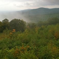
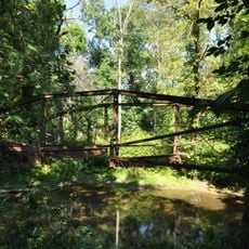
The Shenipsit Trail is a hiking path that runs roughly 50 miles from north to south through Connecticut, passing through varied landscapes. The terrain shifts between rocky ridges, thick forest sections, and more open areas with changing views along the way.

The trail was created in the late 1960s and uses land from two state forests: Shenipsit and Meshomasic. Parts of the route pass through areas where Native Americans lived for many centuries.

The name comes from a Native American language and refers to Shenipsit Lake, which sits along the route. Visitors can still see how this landscape holds meaning tied to the area's original inhabitants.

The path is marked with blue blazes and has several entry points along its length. Hikers should wear sturdy footwear and be prepared for changing weather, especially in the higher sections.

Soapstone Mountain, the highest point, features an observation tower from the 1970s that replaced an earlier fire lookout structure. From here, visitors can see far across the surrounding forests and landscapes on clear days.

The community of curious travelers

AroundUs brings together thousands of curated places, local tips, and hidden gems, enriched daily by 60,000 contributors worldwide.

Start exploring
Location
GPS coordinates
41.95900,-72.41280
Latest update
December 12, 2025 12:05
Around this place
Connecticut Trolley Museum
United States of America

Connecticut Trolley Museum

15.4 km
Hop River State Park Trail
United States of America

Hop River State Park Trail

1.9 km
Daniel Benton Homestead
United States of America

Daniel Benton Homestead

12.3 km
The Tower on Fox Hill
United States of America

The Tower on Fox Hill

11 km
Sonny's Place
United States of America

Sonny's Place

5.5 km
Shenipsit State Forest
United States of America

Shenipsit State Forest

2.8 km
St. Bernard Church
United States of America

St. Bernard Church

10.5 km
Enfield Shakers Historic District
United States of America

Enfield Shakers Historic District

10.3 km
Congregation Knesseth Israel
United States of America

Congregation Knesseth Israel

8.8 km
Hazardville Historic District
United States of America

Hazardville Historic District

10 km
Tolland County Courthouse
United States of America

Tolland County Courthouse

10.4 km
East Windsor Academy
United States of America

East Windsor Academy

15.2 km
Thornton W. Burgess House
United States of America

Thornton W. Burgess House

11.6 km
Tolland Green Historic District
United States of America

Tolland Green Historic District

10.4 km
Somersville Historic District
United States of America

Somersville Historic District

6.8 km
Florence Mill
United States of America

Florence Mill

11.1 km
Enfield Town Meetinghouse
United States of America

Enfield Town Meetinghouse

15 km
Saxony Mill
United States of America

Saxony Mill

11.2 km
Somers Historic District
United States of America

Somers Historic District

4.1 km
Elijah Burt House
United States of America

Elijah Burt House

13.6 km
John Cady House
United States of America

John Cady House

14.3 km
Holt Memorial Fountain
United States of America

Holt Memorial Fountain

9.1 km
Minterburn Mill
United States of America

Minterburn Mill

10.3 km
Ellington Center Historic District
United States of America

Ellington Center Historic District

7.8 km
Swetland-Pease House
United States of America

Swetland-Pease House

11.6 km
Enfield Historic District
United States of America

Enfield Historic District

15.1 km
Melrose Road Bridge
United States of America

Melrose Road Bridge

11.4 km
Rockville Historic District
United States of America

Rockville Historic District

11 km
Show the full map
Reviews
Share your experience

No review yet

Discussions
Start a discussion...

No discussion yet

« Shenipsit Trail - Protected hiking trail in Connecticut, United States » is provided by Around Us (aroundus.com). Images and texts are derived from Wikimedia project under a Creative Commons license. You are allowed to copy, distribute, and modify copies of this page, under the conditions set by the license, as long as this note is clearly visible.

Discover hidden gems everywhere you go!

From secret cafés to breathtaking viewpoints, skip the crowded tourist spots and find places that match your style. Our app makes it easy with voice search, smart filtering, route optimization, and insider tips from travelers worldwide. Download now for the complete mobile experience.

Around Us App Screenshot

A unique approach to discovering new places

Le Figaro

All the places worth exploring

France Info

A tailor-made excursion in just a few clicks

20 Minutes

Around Us
Travel Guide & Maps
Download

Send to your phone

QR Code
1

Open the camera app on your mobile.

2

Point at the QR code with your camera. A notification will appear.

3

Tap the notification to open the link.