Enable Location

We need your location to show you interesting places around you

Discover nearby places

Find interesting locations and hidden gems around you

Precise directions

Get accurate directions and distances to places

Your location is never shared with other users. It's only used when you tap the location button.

The Homestead

Log in to your account

Start exploring — it's free

Trusted by 62,506 travelers worldwide

Continue with Google
Continue with Apple
or

We will send you a code to connect

By continuing, you accept our Terms and Conditions and our Privacy Policy

Check your inbox

We've sent a pincode in your inbox. Please enter the code below.

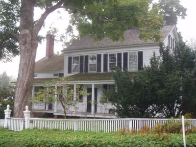
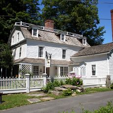
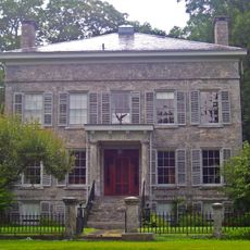
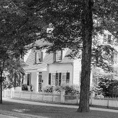
The Homestead, listed on the NRHP in Westchester County, New York

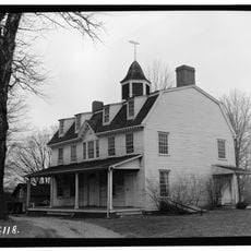
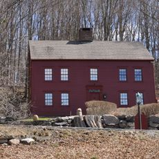
The Homestead is a two-story wood-frame house in Haverstraw, New York, with clapboard siding, five windows across the front, and a small attached kitchen wing. The gabled roof is covered with asphalt shingles, windows are fitted with louvered shutters, and the doorways feature classical details such as columns and architraves.

The house was built around 1800 by Peter Denoyelles, whose family held the land since before the American Revolution as part of a farming community. Throughout the 19th and 20th centuries, it belonged to local leaders including Edward Pye, the first Village Board president, and other notable citizens.

The house served as a gathering place for Methodists who met with traveling preachers, reflecting the religious practices of the early community. This role shows how private homes functioned as centers for communal activities before dedicated buildings existed.

The house is located on Hudson Avenue in Haverstraw on a lot that slopes toward the Hudson River, with the basement visible from the east side. Visitors can view the exterior, though as a private residence it may not be open for interior tours.

The original house faced backward from Hudson Avenue, but when the village laid out streets in the 20th century, it was reoriented so that what is now the front was once the back of the building. This unusual shift reflects how the structure adapted to the urban development of its surroundings.

The community of curious travelers

AroundUs brings together thousands of curated places, local tips, and hidden gems, enriched daily by 60,000 contributors worldwide.

Start exploring
Location
GPS coordinates
41.28306,-73.59556
Latest update
February 9, 2026 07:42
Around this place
IBM Somers Office Complex
United States of America

IBM Somers Office Complex

8.1 km
Elephant Hotel
United States of America

Elephant Hotel

9 km
Cross River Reservoir
United States of America

Cross River Reservoir

4.5 km
Titicus Reservoir
United States of America

Titicus Reservoir

6.1 km
Caramoor Center for Music and the Arts
United States of America

Caramoor Center for Music and the Arts

6.5 km
Keeler Tavern
United States of America

Keeler Tavern

8.3 km
Aldrich Contemporary Art Museum
United States of America

Aldrich Contemporary Art Museum

8.3 km
Bridge L-158
United States of America

Bridge L-158

7.5 km
Frederic Remington House
United States of America

Frederic Remington House

6.6 km
Baxter Preserve
United States of America

Baxter Preserve

6.3 km
Gerard Crane House
United States of America

Gerard Crane House

9 km
Seth Low Pierrepont State Park Reserve
United States of America

Seth Low Pierrepont State Park Reserve

9.3 km
Hammond Museum and Japanese Stroll Garden
United States of America

Hammond Museum and Japanese Stroll Garden

5.6 km
Phineas Chapman Lounsbury House
United States of America

Phineas Chapman Lounsbury House

8.2 km
Joseph Purdy Homestead
United States of America

Joseph Purdy Homestead

7.1 km
Ridgefield Center Historic District
United States of America

Ridgefield Center Historic District

8.2 km
Katonah Village Historic District
United States of America

Katonah Village Historic District

8 km
North Salem Town Hall
United States of America

North Salem Town Hall

5.1 km
West Mountain Historic District
United States of America

West Mountain Historic District

5.8 km
Pound Ridge Historic District
United States of America

Pound Ridge Historic District

8.3 km
Somers Hamlet Historic District
United States of America

Somers Hamlet Historic District

9 km
Benedict House and Shop
United States of America

Benedict House and Shop

8.7 km
Thomas Hyatt House
United States of America

Thomas Hyatt House

8.1 km
Lewis June House
United States of America

Lewis June House

7.8 km
Osborn-Bouton-Mead House
United States of America

Osborn-Bouton-Mead House

3.1 km
Palmer-Lewis Estate
United States of America

Palmer-Lewis Estate

6.1 km
Katonah Museum of Art
United States of America

Katonah Museum of Art

6.9 km
John Jay Homestead State Historic Site
United States of America

John Jay Homestead State Historic Site

6.4 km
Show the full map
« The Homestead - listed on the NRHP in Westchester County, New York » is provided by Around Us (aroundus.com). Images and texts are derived from Wikimedia project under a Creative Commons license. You are allowed to copy, distribute, and modify copies of this page, under the conditions set by the license, as long as this note is clearly visible.

Discover hidden gems everywhere you go!

From secret cafés to breathtaking viewpoints, skip the crowded tourist spots and find places that match your style. Our app makes it easy with voice search, smart filtering, route optimization, and insider tips from travelers worldwide. Download now for the complete mobile experience.

Around Us App Screenshot

A unique approach to discovering new places

Le Figaro

All the places worth exploring

France Info

A tailor-made excursion in just a few clicks

20 Minutes

Around Us
Travel Guide & Maps
Download

Send to your phone

QR Code
1

Open the camera app on your mobile.

2

Point at the QR code with your camera. A notification will appear.

3

Tap the notification to open the link.