Chest opened
+${chestReward.xp} XP
Explorer
NOUVEAU ×${chestReward.collectible.quantity}
tapez pour fermer
Chest locked

Open chests in the app

Around Us is built for your phone — chests unlock when you walk, explore and capture nearby places.

Enable Location

We need your location to show you interesting places around you

Discover nearby places

Find interesting locations and hidden gems around you

Precise directions

Get accurate directions and distances to places

Your location is never shared with other users. It's only used when you tap the location button.

Log in to your account

Start exploring — it's free

Trusted by 72,891 travelers worldwide

Continue with Google
Continue with Apple
or

We will send you a code to connect

By continuing, you accept our Terms and Conditions and our Privacy Policy

Check your inbox

We've sent a pincode in your inbox. Please enter the code below.

The Pocket
Discussion Reviews Photo
1.4k Popularity

The Pocket, Natural valley in Floyd County, United States

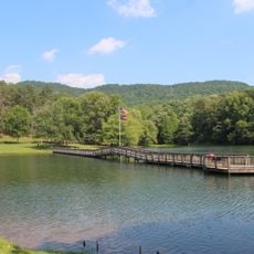
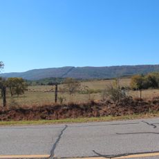
The Pocket is a basin in Georgia's Appalachian Mountains surrounded by Horn Mountain, Mill Mountain, and Johns Mountain. The valley sits within the Conasauga District of the Chattahoochee National Forest and provides space for various outdoor activities.

A Civilian Conservation Corps camp operated here from 1938 to 1941, and some of its building foundations remain visible today. This early presence shaped how the area developed over time.

Local families have maintained connections to this valley for generations through fishing, hiking, and outdoor activities. The area continues to serve as a gathering place for people seeking time in nature.

Visitors can find camping facilities, picnic areas, and hiking trails throughout the valley. Weather in the mountains can change quickly, so it is wise to check conditions before visiting.

The name comes from the curved shape of Horn Mountain, which forms a pocket-like basin in the landscape. This distinctive shape makes the valley easy to recognize and gave it its name.

The community of curious travelers

AroundUs brings together thousands of curated places, local tips, and hidden gems, enriched daily by 60,000 contributors worldwide.

Start exploring
Location
GPS coordinates
34.58000,-85.08000
Latest update
December 14, 2025 17:02
Around this place
Berry College
United States of America

Berry College

32.7 km
New Echota
United States of America

New Echota

16.2 km
United States of America

Ellison's Cave

27.7 km
United States of America

Petty John's Cave

27.6 km
Chief Vann House Historic Site
United States of America

Chief Vann House Historic Site

31.2 km
James H. Floyd State Park
United States of America

James H. Floyd State Park

28.3 km
Oak Hill & The Martha Berry Museum
United States of America

Oak Hill & The Martha Berry Museum

35 km
Chieftains Museum
United States of America

Chieftains Museum

34.7 km
Resaca Confederate Cemetery
United States of America

Resaca Confederate Cemetery

12.8 km
Marsh-Warthen House
United States of America

Marsh-Warthen House

23.4 km
McLemore Cove
United States of America

McLemore Cove

34.4 km
Walker County Courthouse
United States of America

Walker County Courthouse

23 km
Blossom Hill
United States of America

Blossom Hill

35.3 km
Masonic Lodge No. 238
United States of America

Masonic Lodge No. 238

23.1 km
Murray County Courthouse
United States of America

Murray County Courthouse

35.2 km
Dalton Commercial Historic District
United States of America

Dalton Commercial Historic District

23.6 km
Chattooga Academy
United States of America

Chattooga Academy

23.3 km
William Taylor House
United States of America

William Taylor House

12.5 km
Thomas A. Berry House
United States of America

Thomas A. Berry House

24.3 km
Chattooga County Courthouse
United States of America

Chattooga County Courthouse

27 km
United States of America

Penn Place

21.9 km
Summerville Commercial Historic District
United States of America

Summerville Commercial Historic District

27 km
Ainsworth E. Blunt House
United States of America

Ainsworth E. Blunt House

23.1 km
Resaca Battlefield State Historic Site
United States of America

Resaca Battlefield State Historic Site

11.2 km
Movies at Mount Berry Square
United States of America

Movies at Mount Berry Square

32 km
Mars Theatre
United States of America

Mars Theatre

23.7 km
Adairsville Historic District
United States of America

Adairsville Historic District

27.2 km
Walker County African American Museum
United States of America

Walker County African American Museum

23.4 km
Show the full map
Reviews
Share your experience

No review yet

Discussions
Start a discussion...

No discussion yet

« The Pocket - Natural valley in Floyd County, United States » is provided by Around Us (aroundus.com). Images and texts are derived from Wikimedia project under a Creative Commons license. You are allowed to copy, distribute, and modify copies of this page, under the conditions set by the license, as long as this note is clearly visible.

Discover hidden gems everywhere you go!

From secret cafés to breathtaking viewpoints, skip the crowded tourist spots and find places that match your style. Our app makes it easy with voice search, smart filtering, route optimization, and insider tips from travelers worldwide. Download now for the complete mobile experience.

Around Us App Screenshot

A unique approach to discovering new places

Le Figaro

All the places worth exploring

France Info

A tailor-made excursion in just a few clicks

20 Minutes

Around Us
Travel Guide & Maps
Download

Send to your phone

QR Code
1

Open the camera app on your mobile.

2

Point at the QR code with your camera. A notification will appear.

3

Tap the notification to open the link.