U.S. 40 and 59 Bridges

Log in to your account

AroundUs is a community-driven map of interesting places, built by curious explorers like you. It grows with every review, story, and photo you share.
Connect to save your favorite spots, contribute locations, and create personalized routes.
Continue with Google
Continue with Apple
Continue with X
Continue with Facebook
Continue with email
By continuing, you accept our Terms and Conditions and our Privacy Policy
Create an account

U.S. 40 and 59 Bridges

Add to collection
Map
Suggest a change
Share

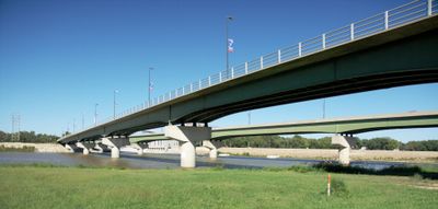
U.S. 40 and 59 Bridges, Road bridge in Lawrence, Kansas.

The U.S. 40 and 59 Bridges are two parallel steel structures that cross the Kansas River, with one bridge handling traffic in each direction. The eastern bridge connects to Massachusetts Street while the western one links to Vermont Street, both meeting North 2nd Street on the north bank.

The first bridge at this location opened in 1864 as the westernmost crossing of the Kansas River beyond Kansas City, initially operating as a toll facility. After severe flooding destroyed earlier structures in the 1870s and 1900s, the current twin bridges were rebuilt in the late 1970s and early 1980s.

The bridges represent the evolution of American transportation infrastructure, connecting communities and facilitating regional commerce between Lawrence and surrounding areas.

The bridges can become congested during heavy rain due to the river's behavior, so it is best to avoid peak traffic times when water flow is strong. Road markings and lane divisions are clearly painted to guide drivers safely across.

These bridges have been rebuilt multiple times following devastating floods, making them a study in how infrastructure adapts to river conditions. Their reconstructions in the 1970s and 1980s reflect changing engineering approaches to handle seasonal water challenges.

Location: Kansas

Official opening: 1864

GPS coordinates: 38.97620,-95.23570

Latest update: December 14, 2025 13:07

Photos
Around this place
David Booth Kansas Memorial Stadium
United States of America

David Booth Kansas Memorial Stadium

1.7 km
University of Kansas Natural History Museum
United States of America

University of Kansas Natural History Museum

2.1 km
Spencer Museum of Art
United States of America

Spencer Museum of Art

2 km
Plymouth Congregational Church
United States of America

Plymouth Congregational Church

1.1 km
Clinton State Park
United States of America

Clinton State Park

12.3 km
Lawrence Public Library
United States of America

Lawrence Public Library

621 m
Lied Center of Kansas
United States of America

Lied Center of Kansas

3.3 km
Haskell-Baker Wetlands
United States of America

Haskell-Baker Wetlands

6.6 km
Bailey Hall
United States of America

Bailey Hall

2.2 km
Granada Theater
United States of America

Granada Theater

1.3 km
Haskell Memorial Stadium
United States of America

Haskell Memorial Stadium

4 km
United States of America

Mount Oread Civil War posts

2.4 km
Spooner Hall
United States of America

Spooner Hall

2.2 km
Strong Hall
United States of America

Strong Hall

2.1 km
Beni Israel Cemetery
United States of America

Beni Israel Cemetery

12 km
St. Luke African Methodist Episcopal Church
United States of America

St. Luke African Methodist Episcopal Church

1.1 km
George and Annie Bell House
United States of America

George and Annie Bell House

1.3 km
S.T. Zimmerman House
United States of America

S.T. Zimmerman House

499 m
Lawrence's Downtown Historic District
United States of America

Lawrence's Downtown Historic District

1.1 km
Douglas County Courthouse
United States of America

Douglas County Courthouse

1.4 km
United Presbyterian Center
United States of America

United Presbyterian Center

1.7 km
Natural History Museum
United States of America

Natural History Museum

2.1 km
Watkins Community Museum of History
United States of America

Watkins Community Museum of History

1.4 km
Lane University
United States of America

Lane University

15.5 km
Oread Historic District
United States of America

Oread Historic District

1.3 km
University of Kansas East Historic District
United States of America

University of Kansas East Historic District

2.2 km
University of Kansas Historic District
United States of America

University of Kansas Historic District

2.3 km
East Lawrence Industrial Historic District
United States of America

East Lawrence Industrial Historic District

1 km
Show the full map
Reviews

Visited this place? Tap the stars to rate it and share your experience / photos with the community! Try now! You can cancel it anytime.

« U.S. 40 and 59 Bridges - Road bridge in Lawrence, Kansas » is provided by Around Us (aroundus.com). Images and texts are derived from Wikimedia project under a Creative Commons license. You are allowed to copy, distribute, and modify copies of this page, under the conditions set by the license, as long as this note is clearly visible.

Discover hidden gems everywhere you go!

From secret cafés to breathtaking viewpoints, skip the crowded tourist spots and find places that match your style. Our app makes it easy with voice search, smart filtering, route optimization, and insider tips from travelers worldwide. Download now for the complete mobile experience.

Around Us App Screenshot

A unique approach to discovering new places

Le Figaro

All the places worth exploring

France Info

A tailor-made excursion in just a few clicks

20 Minutes