Enable Location

We need your location to show you interesting places around you

Discover nearby places

Find interesting locations and hidden gems around you

Precise directions

Get accurate directions and distances to places

Your location is never shared with other users. It's only used when you tap the location button.

U.S. 62 White River Bridge

Log in to your account

Start exploring — it's free

Trusted by 62,813 travelers worldwide

Continue with Google
Continue with Apple
or

We will send you a code to connect

By continuing, you accept our Terms and Conditions and our Privacy Policy

Check your inbox

We've sent a pincode in your inbox. Please enter the code below.

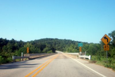
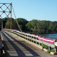
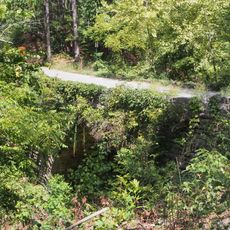
U.S. 62 White River Bridge, Road bridge in Carroll County, Arkansas, US

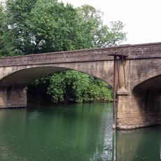
The U.S. 62 White River Bridge is a road bridge spanning the White River in Carroll County with five sections supported by concrete piers and abutments. The structure carries traffic across the river and connects different areas of the county along U.S. Route 62.

The bridge was built between 1950 and 1952 as a steel Warren deck truss by the Forcum-James Company from Dyersburg, Tennessee. It was constructed during a period when new bridge designs helped improve transportation infrastructure across the region.

The bridge represents an important example of mid-20th century transportation infrastructure design and engineering methods in Arkansas.

The bridge provides a straightforward crossing for traffic on U.S. Route 62, connecting the northern and southern sections of the county. The structure is maintained to allow safe passage for vehicles of all sizes.

This is the last remaining deck-truss bridge among eleven originally built in Arkansas and the only one in Carroll County. Its rarity makes it a notable example of mid-century transportation engineering in the region.

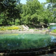
The community of curious travelers

AroundUs brings together thousands of curated places, local tips, and hidden gems, enriched daily by 60,000 contributors worldwide.

Start exploring
Location
GPS coordinates
36.45111,-93.82333
Latest update
December 14, 2025 18:10
Around this place
Beaver Lake
United States of America

Beaver Lake

4 km
Christ of the Ozarks
United States of America

Christ of the Ozarks

10 km
Roaring River State Park
United States of America

Roaring River State Park

15.1 km
Onyx Cave
United States of America

Onyx Cave

12.5 km
Blue Springs Heritage Center
United States of America

Blue Springs Heritage Center

1.9 km
Beaver Bridge
United States of America

Beaver Bridge

5.4 km
Eureka Springs and North Arkansas Railway
United States of America

Eureka Springs and North Arkansas Railway

9 km
Turpentine Creek Wildlife Refuge
United States of America

Turpentine Creek Wildlife Refuge

16.7 km
Quigley's Castle
United States of America

Quigley's Castle

13.2 km
Lake Leatherwood City Park
United States of America

Lake Leatherwood City Park

5.9 km
Eureka Springs Historic District
United States of America

Eureka Springs Historic District

9.4 km
Basin Park Hotel
United States of America

Basin Park Hotel

9.4 km
White River Bridge at Elkins
United States of America

White River Bridge at Elkins

5.4 km
Rocky Branch School
United States of America

Rocky Branch School

17.5 km
Winona Church and School
United States of America

Winona Church and School

18.3 km
Mulladay Hollow Bridge
United States of America

Mulladay Hollow Bridge

5.5 km
Coal Gap School
United States of America

Coal Gap School

13.1 km
Concord School House
United States of America

Concord School House

14.4 km
Sanitarium Lake Bridges Historic District
United States of America

Sanitarium Lake Bridges Historic District

11.3 km
Eureka Springs Historical Museum
United States of America

Eureka Springs Historical Museum

9.4 km
Deer Leap Trail
United States of America

Deer Leap Trail

15.6 km
Holy Land Tour
United States of America

Holy Land Tour

10.5 km
Crescent Spring
United States of America

Crescent Spring

9.2 km
Golden Pioneer Museum
United States of America

Golden Pioneer Museum

16.7 km
Pea Ridge National Military Park Visitor Center
United States of America

Pea Ridge National Military Park Visitor Center

18.1 km
Lake Leatherwood Recreational Facilities
United States of America

Lake Leatherwood Recreational Facilities

6 km
Lake Lucerne Bridge
United States of America

Lake Lucerne Bridge

11.2 km
Lake Leatherwood
United States of America

Lake Leatherwood

6.2 km
Show the full map
« U.S. 62 White River Bridge - Road bridge in Carroll County, Arkansas, US » is provided by Around Us (aroundus.com). Images and texts are derived from Wikimedia project under a Creative Commons license. You are allowed to copy, distribute, and modify copies of this page, under the conditions set by the license, as long as this note is clearly visible.

Discover hidden gems everywhere you go!

From secret cafés to breathtaking viewpoints, skip the crowded tourist spots and find places that match your style. Our app makes it easy with voice search, smart filtering, route optimization, and insider tips from travelers worldwide. Download now for the complete mobile experience.

Around Us App Screenshot

A unique approach to discovering new places

Le Figaro

All the places worth exploring

France Info

A tailor-made excursion in just a few clicks

20 Minutes

Around Us
Travel Guide & Maps
Download

Send to your phone

QR Code
1

Open the camera app on your mobile.

2

Point at the QR code with your camera. A notification will appear.

3

Tap the notification to open the link.