Enable Location

We need your location to show you interesting places around you

Discover nearby places

Find interesting locations and hidden gems around you

Precise directions

Get accurate directions and distances to places

Your location is never shared with other users. It's only used when you tap the location button.

Valley Road Bridge, Stewartstown Railroad

Log in to your account

Start exploring — it's free

Trusted by 62,371 travelers worldwide

Continue with Google
Continue with Apple
or

We will send you a code to connect

By continuing, you accept our Terms and Conditions and our Privacy Policy

Check your inbox

We've sent a pincode in your inbox. Please enter the code below.

Valley Road Bridge, Stewartstown Railroad

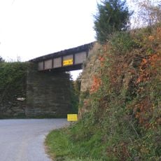
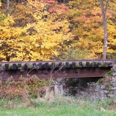
Valley Road Bridge, Stewartstown Railroad, pont américain

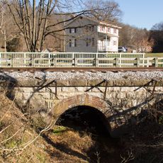
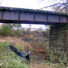
Valley Road Bridge is a railway bridge in Pennsylvania that crosses a road and belongs to the Stewartstown Railroad. The structure is made primarily of metal and uses a truss design that was common in the late 1800s.

The bridge was built in 1870 by the Keystone Bridge Company and originally served the active railroad network. It was later dismantled around 1885 and reassembled at a different location, showing how much the structure was valued and preserved.

The bridge takes its name from Valley Road, the crossing it spans, and represents the role railroads played in connecting small towns throughout the region. Today it stands as a quiet monument to how transportation shaped the community and remains part of local identity.

The site is easily reached in a quiet rural area and works well for visitors interested in railroad history. The best views of the structure come from below or nearby, where the metal framework and historic design are clearly visible.

The bridge uses a rare column design patented by Jacob Hays Linville that features an octagonal geometric shape. This special construction was a clever way to increase the strength of the structure and sets this bridge apart from others of its time.

The community of curious travelers

AroundUs brings together thousands of curated places, local tips, and hidden gems, enriched daily by 60,000 contributors worldwide.

Start exploring
Location
GPS coordinates
39.75528,-76.60944
Latest update
February 9, 2026 07:42
Around this place
Prettyboy Reservoir
United States of America

Prettyboy Reservoir

16.8 km
Rocks State Park
United States of America

Rocks State Park

20.7 km
Ladew Topiary Gardens
United States of America

Ladew Topiary Gardens

21.1 km
My Lady's Manor
United States of America

My Lady's Manor

19 km
Ivory Mills
United States of America

Ivory Mills

10.9 km
Muddy Creek Forks Historic District
United States of America

Muddy Creek Forks Historic District

12.9 km
Glencoe
United States of America

Glencoe

22.8 km
Col. John Streett House
United States of America

Col. John Streett House

18.5 km
Wallace-Cross Mill
United States of America

Wallace-Cross Mill

7.7 km
Guinston United Presbyterian Church
United States of America

Guinston United Presbyterian Church

13.4 km
Gladden Farm
United States of America

Gladden Farm

21.6 km
South Road Bridge, Northern Central Railway
United States of America

South Road Bridge, Northern Central Railway

14.8 km
Bridge 634, Northern Central Railway
United States of America

Bridge 634, Northern Central Railway

9.7 km
Bridge 5+92, Northern Central Railway
United States of America

Bridge 5+92, Northern Central Railway

17.7 km
Stone Arch Road Bridge, Stewartstown Railroad
United States of America

Stone Arch Road Bridge, Stewartstown Railroad

6.7 km
Ridge Road Bridge, Stewartstown Railroad
United States of America

Ridge Road Bridge, Stewartstown Railroad

1.5 km
Deer Creek Bridge, Stewartstown Railroad
United States of America

Deer Creek Bridge, Stewartstown Railroad

3.4 km
Red Lion Borough Historic District
United States of America

Red Lion Borough Historic District

16 km
S. B. Brodbeck Housing
United States of America

S. B. Brodbeck Housing

18.7 km
Jacob F. Shaffer Farm
United States of America

Jacob F. Shaffer Farm

19.9 km
Fissel's School
United States of America

Fissel's School

10.7 km
Chestnut Hill
United States of America

Chestnut Hill

20.5 km
Payne's Folly
United States of America

Payne's Folly

9.8 km
Railroad Borough Historic District
United States of America

Railroad Borough Historic District

7.6 km
Heritage Hills Golf Course
United States of America

Heritage Hills Golf Course

22.7 km
Bridgewater
United States of America

Bridgewater

20.7 km
Nixon County Park
United States of America

Nixon County Park

17.7 km
Kilgore Falls
United States of America

Kilgore Falls

17.1 km
Show the full map
« Valley Road Bridge, Stewartstown Railroad - pont américain » is provided by Around Us (aroundus.com). Images and texts are derived from Wikimedia project under a Creative Commons license. You are allowed to copy, distribute, and modify copies of this page, under the conditions set by the license, as long as this note is clearly visible.

Discover hidden gems everywhere you go!

From secret cafés to breathtaking viewpoints, skip the crowded tourist spots and find places that match your style. Our app makes it easy with voice search, smart filtering, route optimization, and insider tips from travelers worldwide. Download now for the complete mobile experience.

Around Us App Screenshot

A unique approach to discovering new places

Le Figaro

All the places worth exploring

France Info

A tailor-made excursion in just a few clicks

20 Minutes

Around Us
Travel Guide & Maps
Download

Send to your phone

QR Code
1

Open the camera app on your mobile.

2

Point at the QR code with your camera. A notification will appear.

3

Tap the notification to open the link.