Prettyboy Reservoir

Log in to your account

AroundUs is a community-driven map of interesting places, built by curious explorers like you. It grows with every review, story, and photo you share.
Connect to save your favorite spots, contribute locations, and create personalized routes.
Continue with Google
Continue with Apple
Continue with X
Continue with Facebook
Continue with email
By continuing, you accept our Terms and Conditions and our Privacy Policy
Create an account
Add to collection
Map
Suggest a change
Share

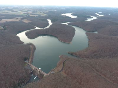
Prettyboy Reservoir, Public water reservoir in Hampstead, Maryland, United States

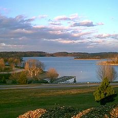
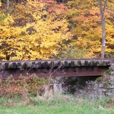
Prettyboy Reservoir is a large water body in Baltimore County surrounded by dense forests and rolling terrain. Hiking trails wind along the shoreline, connecting different access points and recreation areas throughout the property.

The dam was completed in 1932 by the Baltimore City Department of Public Works to meet the region's growing water demands. The project was part of a broader effort to secure reliable water supply for Baltimore and surrounding areas.

Designated fishing spots around the water's edge draw locals who spend afternoons casting lines for bass and other species in a social ritual. These gatherings have become part of the area's outdoor traditions for generations.

The site is open during daylight hours for visitors interested in hiking, fishing, and nature exploration. It helps to know the trails beforehand and plan your route, as some areas may have limited access or seasonal closures.

The name comes from a settler's horse that drowned in a nearby creek many years ago, giving the water body its permanent name. This unusual origin story is part of local folklore and often overlooked by visitors.

Location: Maryland

Website: https://prettyboyreservoir.org

GPS coordinates: 39.64320,-76.74080

Latest update: December 8, 2025 19:53

Photos
Around this place
Codorus State Park
United States of America

Codorus State Park

21.9 km
Ladew Topiary Gardens
United States of America

Ladew Topiary Gardens

20.8 km
My Lady's Manor
United States of America

My Lady's Manor

15.8 km
Whittaker Chambers Farm
United States of America

Whittaker Chambers Farm

20.3 km
Worthington Valley Historic District
United States of America

Worthington Valley Historic District

16 km
Bear Branch Nature Center
United States of America

Bear Branch Nature Center

21.4 km
Stone Hall
United States of America

Stone Hall

15.3 km
Ivory Mills
United States of America

Ivory Mills

17.8 km
Glyndon Historic District
United States of America

Glyndon Historic District

19.7 km
Valley Road Bridge, Stewartstown Railroad
United States of America

Valley Road Bridge, Stewartstown Railroad

16.8 km
Glencoe
United States of America

Glencoe

13.7 km
Charlotte's Quest Nature Center
United States of America

Charlotte's Quest Nature Center

12.2 km
Hampstead School
United States of America

Hampstead School

10.1 km
South Road Bridge, Northern Central Railway
United States of America

South Road Bridge, Northern Central Railway

19.8 km
Bridge 634, Northern Central Railway
United States of America

Bridge 634, Northern Central Railway

14.6 km
Stone Arch Road Bridge, Stewartstown Railroad
United States of America

Stone Arch Road Bridge, Stewartstown Railroad

12.8 km
Western Run-Belfast Road Historic District
United States of America

Western Run-Belfast Road Historic District

13.3 km
Ridge Road Bridge, Stewartstown Railroad
United States of America

Ridge Road Bridge, Stewartstown Railroad

16.3 km
Deer Creek Bridge, Stewartstown Railroad
United States of America

Deer Creek Bridge, Stewartstown Railroad

15.1 km
Baltimore County School No. 7
United States of America

Baltimore County School No. 7

18.5 km
S. B. Brodbeck Housing
United States of America

S. B. Brodbeck Housing

16 km
Jacob F. Shaffer Farm
United States of America

Jacob F. Shaffer Farm

9.9 km
Fissel's School
United States of America

Fissel's School

13.9 km
John Orendorff Farm
United States of America

John Orendorff Farm

21.4 km
Beaver Dam Swim Club
United States of America

Beaver Dam Swim Club

19.7 km
Railroad Borough Historic District
United States of America

Railroad Borough Historic District

13.5 km
Robinson-Tabb House
United States of America

Robinson-Tabb House

13.5 km
Lacrosse Museum and National Hall of Fame
United States of America

Lacrosse Museum and National Hall of Fame

15.9 km
Show the full map
Reviews

Visited this place? Tap the stars to rate it and share your experience / photos with the community! Try now! You can cancel it anytime.

« Prettyboy Reservoir - Public water reservoir in Hampstead, Maryland, United States » is provided by Around Us (aroundus.com). Images and texts are derived from Wikimedia project under a Creative Commons license. You are allowed to copy, distribute, and modify copies of this page, under the conditions set by the license, as long as this note is clearly visible.

Discover hidden gems everywhere you go!

From secret cafés to breathtaking viewpoints, skip the crowded tourist spots and find places that match your style. Our app makes it easy with voice search, smart filtering, route optimization, and insider tips from travelers worldwide. Download now for the complete mobile experience.

Around Us App Screenshot

A unique approach to discovering new places

Le Figaro

All the places worth exploring

France Info

A tailor-made excursion in just a few clicks

20 Minutes