Enable Location

We need your location to show you interesting places around you

Discover nearby places

Find interesting locations and hidden gems around you

Precise directions

Get accurate directions and distances to places

Your location is never shared with other users. It's only used when you tap the location button.

West Dennis Light

Log in to your account

Start exploring — it's free

Trusted by 62,575 travelers worldwide

Continue with Google
Continue with Apple
or

We will send you a code to connect

By continuing, you accept our Terms and Conditions and our Privacy Policy

Check your inbox

We've sent a pincode in your inbox. Please enter the code below.

West Dennis Light

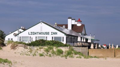
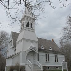
West Dennis Light, Lighthouse in West Dennis, Massachusetts, US

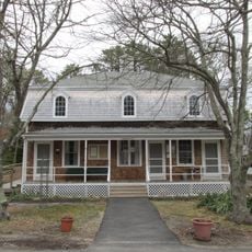
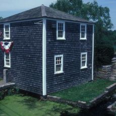
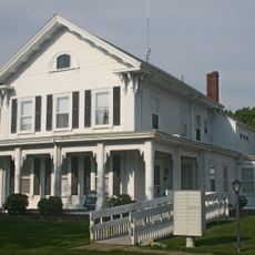
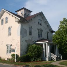
West Dennis Light is a conical iron tower that rises from the roof of the former keeper's house, creating a compact structure. The light mechanism sits atop this residential building rather than standing separately on the beach or a distant point.

The light was established in 1855 to replace an older signaling system that operated from an attic. It was later deactivated when a newer beacon was built elsewhere to better serve increasing maritime traffic in the region.

The light served generations of local fishermen and sea captains as a trusted navigation point. The maritime community that worked these waters relied on this beacon to guide them safely back to port.

The light sits atop a functioning hotel that operates on a seasonal basis. Access to the structure depends on the hotel's business hours, so check current availability before visiting.

Unlike other Cape Cod lighthouses that stand isolated on rocky shores, this one emerges directly from a residential building. The unusual construction, where the tower and dwelling merged into a single structure, set it apart as an architectural oddity among the region's navigation aids.

The community of curious travelers

AroundUs brings together thousands of curated places, local tips, and hidden gems, enriched daily by 60,000 contributors worldwide.

Start exploring
Location
Inception
1855
GPS coordinates
41.65173,-70.16917
Latest update
December 12, 2025 17:45
Around this place
Cape Cod Coliseum
United States of America

Cape Cod Coliseum

4.8 km
Elephant House
United States of America

Elephant House

8.5 km
John F. Kennedy Hyannis Museum
United States of America

John F. Kennedy Hyannis Museum

9.6 km
Red Wilson Field
United States of America

Red Wilson Field

3.4 km
McKeon Park
United States of America

McKeon Park

9.5 km
Whydah Pirate Museum
United States of America

Whydah Pirate Museum

4.6 km
Judah Baker Windmill
United States of America

Judah Baker Windmill

2.3 km
Yarmouth Camp Ground Historic District
United States of America

Yarmouth Camp Ground Historic District

8.5 km
Baxter Mill
United States of America

Baxter Mill

7.8 km
Cape Cod Inflatable Park
United States of America

Cape Cod Inflatable Park

5.5 km
Hyannis Armory
United States of America

Hyannis Armory

9.5 km
Winslow Crocker House
United States of America

Winslow Crocker House

7.9 km
Cape Cod Maritime Museum
United States of America

Cape Cod Maritime Museum

9.2 km
Capt. Rodney J. Baxter House
United States of America

Capt. Rodney J. Baxter House

9.6 km
Harwich Historic District
United States of America

Harwich Historic District

9 km
Dr. Edward Francis Gleason House
United States of America

Dr. Edward Francis Gleason House

8.8 km
South Yarmouth/Bass River Historic District
United States of America

South Yarmouth/Bass River Historic District

2.2 km
Northside Historic District
United States of America

Northside Historic District

8.5 km
Seth Hallett House
United States of America

Seth Hallett House

8.9 km
Capt. Oliver Bearse House
United States of America

Capt. Oliver Bearse House

9.7 km
Capt. Thomas Gray House
United States of America

Capt. Thomas Gray House

8.6 km
Capt. Allen H. Bearse House
United States of America

Capt. Allen H. Bearse House

8.9 km
Capt. Seth Baker Jr. House
United States of America

Capt. Seth Baker Jr. House

8.6 km
Captain James Berry House
United States of America

Captain James Berry House

4.6 km
Municipal Group Historic District
United States of America

Municipal Group Historic District

9.5 km
Capt. Sylvester Baxter House
United States of America

Capt. Sylvester Baxter House

9 km
Pleasant-School Street Historic District
United States of America

Pleasant-School Street Historic District

9.1 km
Taylor-Bray Farm
United States of America

Taylor-Bray Farm

8.3 km
Show the full map
« West Dennis Light - Lighthouse in West Dennis, Massachusetts, US » is provided by Around Us (aroundus.com). Images and texts are derived from Wikimedia project under a Creative Commons license. You are allowed to copy, distribute, and modify copies of this page, under the conditions set by the license, as long as this note is clearly visible.

Discover hidden gems everywhere you go!

From secret cafés to breathtaking viewpoints, skip the crowded tourist spots and find places that match your style. Our app makes it easy with voice search, smart filtering, route optimization, and insider tips from travelers worldwide. Download now for the complete mobile experience.

Around Us App Screenshot

A unique approach to discovering new places

Le Figaro

All the places worth exploring

France Info

A tailor-made excursion in just a few clicks

20 Minutes

Around Us
Travel Guide & Maps
Download

Send to your phone

QR Code
1

Open the camera app on your mobile.

2

Point at the QR code with your camera. A notification will appear.

3

Tap the notification to open the link.