Enable Location

We need your location to show you interesting places around you

Discover nearby places

Find interesting locations and hidden gems around you

Precise directions

Get accurate directions and distances to places

Your location is never shared with other users. It's only used when you tap the location button.

Whitney Young Memorial Bridge

Log in to your account

Start exploring — it's free

Trusted by 63,055 travelers worldwide

Continue with Google
Continue with Apple
or

We will send you a code to connect

By continuing, you accept our Terms and Conditions and our Privacy Policy

Check your inbox

We've sent a pincode in your inbox. Please enter the code below.

Whitney Young Memorial Bridge
Discussion Reviews 1 Photos
2.9k Popularity

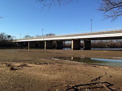
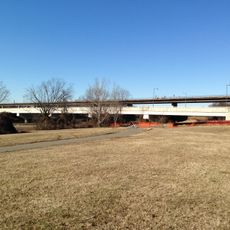
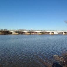
Whitney Young Memorial Bridge, Road bridge in Washington, D.C., United States.

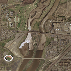
The Whitney Young Memorial Bridge is a six-lane road bridge that crosses the Anacostia River with multiple supporting spans. It connects eastern and western neighborhoods of Washington, serving as a major thoroughfare across the river.

The bridge was originally completed in 1955 as the East Capitol Street Bridge and renamed in 1974 to honor civil rights leader Whitney Young. The renaming reflected recognition of his decades of work for social progress and equality.

The bridge carries the name of Whitney Young, a leader in the civil rights movement whose work for social justice is remembered through this public structure. Visitors crossing it engage with a living tribute to his advocacy and influence.

The bridge is located at East Capitol Street Southeast near RFK Memorial Stadium and accommodates both vehicle and pedestrian traffic. Those planning to visit should allow time for congestion, as it carries significant traffic volumes throughout the day.

The bridge is supported by substantial concrete piers that break through the water and create an imposing profile when viewed from the riverside. These structural elements form a notable part of the river's visual character and display the engineering required for such a major crossing.

The community of curious travelers

AroundUs brings together thousands of curated places, local tips, and hidden gems, enriched daily by 60,000 contributors worldwide.

Start exploring
Location
GPS coordinates
38.88980,-76.96500
Latest update
December 12, 2025 14:27
Around this place
Emancipation Memorial
United States of America

Emancipation Memorial

2.2 km
Congressional Cemetery
United States of America

Congressional Cemetery

1.4 km
United States National Arboretum
United States of America

United States National Arboretum

2.3 km
National Capitol Columns
United States of America

National Capitol Columns

2.3 km
D.C. Jail
United States of America

D.C. Jail

1.2 km
Mary McLeod Bethune Memorial
United States of America

Mary McLeod Bethune Memorial

2.1 km
Lincoln Park
United States of America

Lincoln Park

2.1 km
Kingman Island
United States of America

Kingman Island

1 km
Langston Golf Course
United States of America

Langston Golf Course

1.5 km
Fort Dupont Park
United States of America

Fort Dupont Park

1.9 km
Dupont Park
United States of America

Dupont Park

1.9 km
Benning
United States of America

Benning

1.4 km
Atlas Performing Arts Center
United States of America

Atlas Performing Arts Center

2.2 km
East Capitol Street Car Barn
United States of America

East Capitol Street Car Barn

1.7 km
Public Vault at the Congressional Cemetery
United States of America

Public Vault at the Congressional Cemetery

1.5 km
John Philip Sousa Junior High School
United States of America

John Philip Sousa Junior High School

1.3 km
Gallinger Municipal Hospital Psychopathic Ward
United States of America

Gallinger Municipal Hospital Psychopathic Ward

1.2 km
Ethel Kennedy Bridge
United States of America

Ethel Kennedy Bridge

831 m
Mayfair Mansions Apartments
United States of America

Mayfair Mansions Apartments

2 km
Holy Comforter-St. Cyprian Catholic Church
United States of America

Holy Comforter-St. Cyprian Catholic Church

1.8 km
Anacostia Railroad Bridge
United States of America

Anacostia Railroad Bridge

1.2 km
Alexander Dallas Bache Monument
United States of America

Alexander Dallas Bache Monument

1.5 km
Pennsylvania Avenue Bridge
United States of America

Pennsylvania Avenue Bridge

1.8 km
Benning / Dorothy I. Height Neighborhood Library
United States of America

Benning / Dorothy I. Height Neighborhood Library

1.6 km
Rosedale Neighborhood Library
United States of America

Rosedale Neighborhood Library

1.5 km
John Philip Sousa Bridge
United States of America

John Philip Sousa Bridge

1.8 km
Latrobe cenotaphs
United States of America

Latrobe cenotaphs

1.5 km
Fort Mahan
United States of America

Fort Mahan

1.8 km
Show the full map
Reviews
Share your experience

No review yet

Discussions
Start a discussion...

No discussion yet

« Whitney Young Memorial Bridge - Road bridge in Washington, D.C., United States » is provided by Around Us (aroundus.com). Images and texts are derived from Wikimedia project under a Creative Commons license. You are allowed to copy, distribute, and modify copies of this page, under the conditions set by the license, as long as this note is clearly visible.

Discover hidden gems everywhere you go!

From secret cafés to breathtaking viewpoints, skip the crowded tourist spots and find places that match your style. Our app makes it easy with voice search, smart filtering, route optimization, and insider tips from travelers worldwide. Download now for the complete mobile experience.

Around Us App Screenshot

A unique approach to discovering new places

Le Figaro

All the places worth exploring

France Info

A tailor-made excursion in just a few clicks

20 Minutes

Around Us
Travel Guide & Maps
Download

Send to your phone

QR Code
1

Open the camera app on your mobile.

2

Point at the QR code with your camera. A notification will appear.

3

Tap the notification to open the link.