Enable Location

We need your location to show you interesting places around you

Discover nearby places

Find interesting locations and hidden gems around you

Precise directions

Get accurate directions and distances to places

Your location is never shared with other users. It's only used when you tap the location button.

Kingman Island

Log in to your account

Start exploring — it's free

Trusted by 61,860 travelers worldwide

Continue with Google
Continue with Apple
or

We will send you a code to connect

By continuing, you accept our Terms and Conditions and our Privacy Policy

Check your inbox

We've sent a pincode in your inbox. Please enter the code below.

Kingman Island

Kingman Island, River island in Washington D.C., United States.
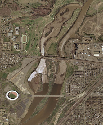
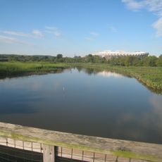
Description

Kingman Island is an artificial island in the Anacostia River featuring tidal marshes, a lake, and interconnected pathways for visitors to explore. The landscape includes restored wetland areas and open meadows supporting diverse plant and animal life.

History

The island was created in 1916 by the US Army Corps of Engineers as a result of dredging operations on the Anacostia River. Later restoration efforts transformed it from industrial land into a protected natural area for wildlife and wetland ecology.

Culture

This island serves as a place where people observe wildlife and learn about wetland ecology through interpretive programs and trails. The site emphasizes connection between visitors and the natural world that depends on these restored habitats.

Practical

The island is accessible via a renovated pedestrian bridge near the RFK Stadium area and offers multiple walking trails of varying difficulty. Plan your visit during spring and fall when weather conditions are most comfortable for outdoor exploration.

Did you know?

The southern section protects vernal pools that fill seasonally with water, creating crucial habitat for specialized amphibians found nowhere else in the city. These temporary wetlands support a breeding cycle that depends on the natural flood pattern of the Anacostia River.

Location
GPS coordinates
38.89900,-76.96442
Latest update
December 21, 2025 16:05

AroundUs brings together thousands of curated places, local tips, and hidden gems, enriched daily by 60,000 contributors worldwide. Discover all places nearby (Washington, D.C.).

Around this place
Congressional Cemetery
United States of America

Congressional Cemetery

2.3 km
United States National Arboretum
United States of America

United States National Arboretum

1.3 km
National Capitol Columns
United States of America

National Capitol Columns

1.3 km
Northeast
United States of America

Northeast

1.8 km
D.C. Jail
United States of America

D.C. Jail

2 km
Mary McLeod Bethune Memorial
United States of America

Mary McLeod Bethune Memorial

2.4 km
Lincoln Park
United States of America

Lincoln Park

2.4 km
Goshin
United States of America

Goshin

1.5 km
Langston Golf Course
United States of America

Langston Golf Course

511 m
Langston Terrace Dwellings
United States of America

Langston Terrace Dwellings

822 m
Benning
United States of America

Benning

1.5 km
Atlas Performing Arts Center
United States of America

Atlas Performing Arts Center

2 km
East Capitol Street Car Barn
United States of America

East Capitol Street Car Barn

2 km
Public Vault at the Congressional Cemetery
United States of America

Public Vault at the Congressional Cemetery

2.3 km
Whitney Young Memorial Bridge
United States of America

Whitney Young Memorial Bridge

1 km
Ethel Kennedy Bridge
United States of America

Ethel Kennedy Bridge

212 m
Mayfair Mansions Apartments
United States of America

Mayfair Mansions Apartments

1.4 km
Holy Comforter-St. Cyprian Catholic Church
United States of America

Holy Comforter-St. Cyprian Catholic Church

2.1 km
Anacostia Railroad Bridge
United States of America

Anacostia Railroad Bridge

2.2 km
Alexander Dallas Bache Monument
United States of America

Alexander Dallas Bache Monument

2.3 km
H Street Playhouse
United States of America

H Street Playhouse

1.9 km
Benning / Dorothy I. Height Neighborhood Library
United States of America

Benning / Dorothy I. Height Neighborhood Library

1.5 km
Roosevelt Apartment Building
United States of America

Roosevelt Apartment Building

2.2 km
Rosedale Neighborhood Library
United States of America

Rosedale Neighborhood Library

1.2 km
National Bonsai and Penjing Museum
United States of America

National Bonsai and Penjing Museum

1.5 km
Latrobe cenotaphs
United States of America

Latrobe cenotaphs

2.3 km
Fort Mahan
United States of America

Fort Mahan

1.7 km
Kingman Lake
United States of America

Kingman Lake

294 m
Show the full map
« Kingman Island - River island in Washington D.C., United States » is provided by Around Us (aroundus.com). Images and texts are derived from Wikimedia project under a Creative Commons license. You are allowed to copy, distribute, and modify copies of this page, under the conditions set by the license, as long as this note is clearly visible.

Discover hidden gems everywhere you go!

From secret cafés to breathtaking viewpoints, skip the crowded tourist spots and find places that match your style. Our app makes it easy with voice search, smart filtering, route optimization, and insider tips from travelers worldwide. Download now for the complete mobile experience.

Around Us App Screenshot

A unique approach to discovering new places

Le Figaro

All the places worth exploring

France Info

A tailor-made excursion in just a few clicks

20 Minutes

Around Us
Travel Guide & Maps
Download

Send to your phone

QR Code
1

Open the camera app on your mobile.

2

Point at the QR code with your camera. A notification will appear.

3

Tap the notification to open the link.