Enable Location

We need your location to show you interesting places around you

Discover nearby places

Find interesting locations and hidden gems around you

Precise directions

Get accurate directions and distances to places

Your location is never shared with other users. It's only used when you tap the location button.

William H. Natcher Bridge

Log in to your account

Start exploring — it's free

Trusted by 62,161 travelers worldwide

Continue with Google
Continue with Apple
or

We will send you a code to connect

By continuing, you accept our Terms and Conditions and our Privacy Policy

Check your inbox

We've sent a pincode in your inbox. Please enter the code below.

William H. Natcher Bridge

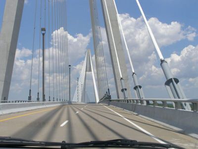
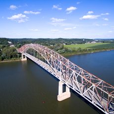
William H. Natcher Bridge, Cable-stayed bridge over Ohio River between Kentucky and Indiana, United States.

The William H. Natcher Bridge is a cable-stayed structure that spans the Ohio River between Owensboro, Kentucky and Rockport, Indiana. Two concrete towers support the main span, which handles traffic on US Highway 231 crossing from state to state.

Construction started in 1998 and the bridge opened to traffic in 2002, creating a major crossing for the region. It was built to handle growing transportation needs between the two states where previous options had become inadequate.

The bridge received its name from William Huston Natcher, who represented Kentucky's 2nd Congressional District from 1954 until 1994.

The bridge is open daily for vehicle traffic and provides a straightforward crossing between the two states without delay. The highway is clearly marked and easy to navigate for drivers heading between Owensboro and Rockport.

The bridge holds the distinction of being the longest cable-stayed structure over any inland waterway system in the United States.

The community of curious travelers

AroundUs brings together thousands of curated places, local tips, and hidden gems, enriched daily by 60,000 contributors worldwide.

Start exploring
Location
Location
Inception
October 21, 2002
Official opening
October 21, 2002
GPS coordinates
37.90120,-87.03390
Latest update
December 10, 2025 20:10
Around this place
Lincoln Boyhood National Memorial
United States of America

Lincoln Boyhood National Memorial

24.4 km
Lincoln State Park
United States of America

Lincoln State Park

22.8 km
Glover Cary Bridge
United States of America

Glover Cary Bridge

15.1 km
St. Stephen's Cathedral
United States of America

St. Stephen's Cathedral

16.3 km
Temple Adath Israel
United States of America

Temple Adath Israel

15.9 km
Cannelton Cotton Mill
United States of America

Cannelton Cotton Mill

25.3 km
Yankeetown Site
United States of America

Yankeetown Site

23.9 km
Col. William Jones House
United States of America

Col. William Jones House

23.7 km
Bob Cummings – Lincoln Trail Bridge
United States of America

Bob Cummings – Lincoln Trail Bridge

25.5 km
Western Kentucky Botanical Garden
United States of America

Western Kentucky Botanical Garden

17 km
Christ of the Ohio
United States of America

Christ of the Ohio

23.2 km
Haphazard
United States of America

Haphazard

13.7 km
Confederate Monument in Owensboro
United States of America

Confederate Monument in Owensboro

15.8 km
St. Joseph's Catholic Church
United States of America

St. Joseph's Catholic Church

15.7 km
Mathias Sharp House
United States of America

Mathias Sharp House

2.5 km
Odd Fellows Building
United States of America

Odd Fellows Building

15.8 km
Trinity Episcopal Church
United States of America

Trinity Episcopal Church

16 km
Spencer County Courthouse
United States of America

Spencer County Courthouse

2.4 km
Joe Pell Building
United States of America

Joe Pell Building

12.2 km
Cannelton Historic District
United States of America

Cannelton Historic District

25.6 km
Tell City Oddfellows' Hall
United States of America

Tell City Oddfellows' Hall

23.8 km
Felix Grimes House
United States of America

Felix Grimes House

15.9 km
Le Vega Clements House
United States of America

Le Vega Clements House

15 km
Yewell House
United States of America

Yewell House

15.9 km
United States of America

Lewisport Masonic Lodge

12.2 km
Hancock County Courthouse
United States of America

Hancock County Courthouse

25 km
Robert C. Beauchamp House
United States of America

Robert C. Beauchamp House

20.2 km
Immaculate Conception Church
United States of America

Immaculate Conception Church

24.6 km
Show the full map
« William H. Natcher Bridge - Cable-stayed bridge over Ohio River between Kentucky and Indiana, United States » is provided by Around Us (aroundus.com). Images and texts are derived from Wikimedia project under a Creative Commons license. You are allowed to copy, distribute, and modify copies of this page, under the conditions set by the license, as long as this note is clearly visible.

Discover hidden gems everywhere you go!

From secret cafés to breathtaking viewpoints, skip the crowded tourist spots and find places that match your style. Our app makes it easy with voice search, smart filtering, route optimization, and insider tips from travelers worldwide. Download now for the complete mobile experience.

Around Us App Screenshot

A unique approach to discovering new places

Le Figaro

All the places worth exploring

France Info

A tailor-made excursion in just a few clicks

20 Minutes

Around Us
Travel Guide & Maps
Download

Send to your phone

QR Code
1

Open the camera app on your mobile.

2

Point at the QR code with your camera. A notification will appear.

3

Tap the notification to open the link.