Enable Location

We need your location to show you interesting places around you

Discover nearby places

Find interesting locations and hidden gems around you

Precise directions

Get accurate directions and distances to places

Your location is never shared with other users. It's only used when you tap the location button.

Susquehanna River Bridge

Log in to your account

Start exploring — it's free

Trusted by 62,384 travelers worldwide

Continue with Google
Continue with Apple
or

We will send you a code to connect

By continuing, you accept our Terms and Conditions and our Privacy Policy

Check your inbox

We've sent a pincode in your inbox. Please enter the code below.

Susquehanna River Bridge

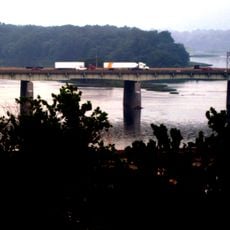
Susquehanna River Bridge, Road bridge over Susquehanna River near Harrisburg, United States.

The Susquehanna River Bridge is a road bridge spanning the river near Harrisburg that connects Dauphin and York counties. It consists of two parallel concrete structures, each carrying three lanes of interstate highway traffic.

An original steel structure opened in 1950 and used materials from local steel production in the region. In 2007 it was replaced with two separate concrete structures to accommodate growing traffic.

The bridge connects two riverbanks and enables daily movement between communities on either side of the water. People use this crossing regularly to travel for work, errands, or to visit family across the river.

The bridge is part of a toll highway and connects two important regions of the state. Travel during midday hours to avoid congestion, especially during morning and evening rush periods.

The concrete structures built in 2007 represent a distinctive engineering design that was implemented for the first time in this form in Pennsylvania. This configuration provides clear separation of traffic flowing in opposite directions.

The community of curious travelers

AroundUs brings together thousands of curated places, local tips, and hidden gems, enriched daily by 60,000 contributors worldwide.

Start exploring
Location
Inception
1950
Official opening
1950
GPS coordinates
40.20420,-76.80500
Latest update
December 12, 2025 12:02
Around this place
Philadelphia & Reading Railroad Bridge
United States of America

Philadelphia & Reading Railroad Bridge

8.3 km
Cumberland Valley Railroad Bridge
United States of America

Cumberland Valley Railroad Bridge

8.7 km
Whitaker Center for Science and the Arts
United States of America

Whitaker Center for Science and the Arts

9 km
Simon Cameron House
United States of America

Simon Cameron House

8.6 km
Market Street Bridge
United States of America

Market Street Bridge

8.9 km
Dauphin County Courthouse
United States of America

Dauphin County Courthouse

8.9 km
Star Barn Complex
United States of America

Star Barn Complex

3.6 km
Mulberry Street Bridge
United States of America

Mulberry Street Bridge

8.7 km
Penn State Harrisburg Library
United States of America

Penn State Harrisburg Library

5.4 km
National Civil War Museum
United States of America

National Civil War Museum

8.7 km
Calver Island
United States of America

Calver Island

213 m
Etters Bridge
United States of America

Etters Bridge

8.2 km
B'nai Jacob Synagogue
United States of America

B'nai Jacob Synagogue

6 km
Charles and Joseph Raymond Houses
United States of America

Charles and Joseph Raymond Houses

6.4 km
William Black Homestead
United States of America

William Black Homestead

7 km
Mount Pleasant Historic District
United States of America

Mount Pleasant Historic District

8.3 km
Simon Cameron House and Bank
United States of America

Simon Cameron House and Bank

6.3 km
Harrisburg Historic District
United States of America

Harrisburg Historic District

9 km
Swatara Ferry House
United States of America

Swatara Ferry House

6.3 km
Henry Smith Farm
United States of America

Henry Smith Farm

7.7 km
Hammersly-Strominger House
United States of America

Hammersly-Strominger House

7.8 km
William Seel Building
United States of America

William Seel Building

9 km
Goldsboro Historic District
United States of America

Goldsboro Historic District

7.3 km
Conrad and Margaret Allerman House
United States of America

Conrad and Margaret Allerman House

5.7 km
Holy Annunciation Macedonian Bulgarian Eastern Orthodox Church
Bulgaria

Holy Annunciation Macedonian Bulgarian Eastern Orthodox Church

5.4 km
John Harris Bridge
United States of America

John Harris Bridge

7.9 km
Old Downtown Harrisburg Commercial Historic District
United States of America

Old Downtown Harrisburg Commercial Historic District

8.9 km
Kunkel Building
United States of America

Kunkel Building

9 km
Show the full map
« Susquehanna River Bridge - Road bridge over Susquehanna River near Harrisburg, United States » is provided by Around Us (aroundus.com). Images and texts are derived from Wikimedia project under a Creative Commons license. You are allowed to copy, distribute, and modify copies of this page, under the conditions set by the license, as long as this note is clearly visible.

Discover hidden gems everywhere you go!

From secret cafés to breathtaking viewpoints, skip the crowded tourist spots and find places that match your style. Our app makes it easy with voice search, smart filtering, route optimization, and insider tips from travelers worldwide. Download now for the complete mobile experience.

Around Us App Screenshot

A unique approach to discovering new places

Le Figaro

All the places worth exploring

France Info

A tailor-made excursion in just a few clicks

20 Minutes

Around Us
Travel Guide & Maps
Download

Send to your phone

QR Code
1

Open the camera app on your mobile.

2

Point at the QR code with your camera. A notification will appear.

3

Tap the notification to open the link.