Chest opened
+${chestReward.xp} XP
Explorer
NOUVEAU ×${chestReward.collectible.quantity}
tapez pour fermer
Chest locked

Open chests in the app

Around Us is built for your phone — chests unlock when you walk, explore and capture nearby places.

Enable Location

We need your location to show you interesting places around you

Discover nearby places

Find interesting locations and hidden gems around you

Precise directions

Get accurate directions and distances to places

Your location is never shared with other users. It's only used when you tap the location button.

Log in to your account

Start exploring — it's free

Trusted by 72,976 travelers worldwide

Continue with Google
Continue with Apple
or

We will send you a code to connect

By continuing, you accept our Terms and Conditions and our Privacy Policy

Check your inbox

We've sent a pincode in your inbox. Please enter the code below.

Discussion Reviews Photo
3.3k Popularity

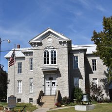
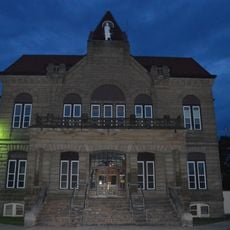
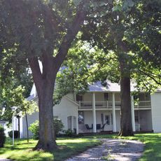
Greene County Almshouse, Poorhouse in Carrollton, Illinois, US

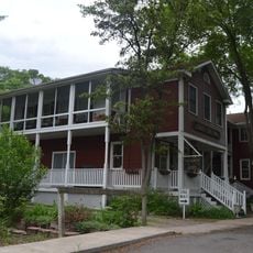
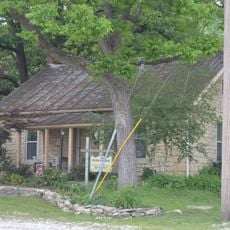
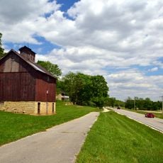
Greene County Almshouse is a poorhouse located northeast of Carrollton with Italianate architectural style, featuring multiple buildings and farm areas on its grounds. The property includes living quarters, work spaces, and surrounding orchards that once supported daily operations.

This poorhouse was built in 1870 following state legislation from 1839 that established provisions for housing the poor. It operated as a residential facility for people in need throughout its early decades.

The institution transformed from a general poorhouse into an elderly care facility, with 90 percent of residents over 60 years old by 1928.

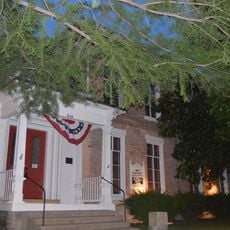
This registered historic property is listed on the National Register of Historic Places and can be viewed from the exterior. Be aware that the structure has experienced damage in recent years, so access may be restricted.

A cemetery on the grounds holds graves of former residents and received a memorial marker in 2022 after community petition. This burial ground reflects the facility's role in caring for those without family support.

The community of curious travelers

AroundUs brings together thousands of curated places, local tips, and hidden gems, enriched daily by 60,000 contributors worldwide.

Start exploring
Location
Inception
1907
GPS coordinates
39.29670,-90.40810
Latest update
December 12, 2025 09:02
Around this place
Koster Site
United States of America

Koster Site

15.6 km
Goldenrod
United States of America

Goldenrod

18.8 km
Lock and Dam No. 25
United States of America

Lock and Dam No. 25

40.4 km
Two Rivers National Wildlife Refuge
United States of America

Two Rivers National Wildlife Refuge

33.2 km
Beaver Dam State Park
United States of America

Beaver Dam State Park

38.4 km
Clarence Cannon National Wildlife Refuge
United States of America

Clarence Cannon National Wildlife Refuge

32.6 km
Kamp Mound Site
United States of America

Kamp Mound Site

18.7 km
Hamilton Primary School
United States of America

Hamilton Primary School

27.4 km
Principia College Historic District
United States of America

Principia College Historic District

39.1 km
Duncan Farm
United States of America

Duncan Farm

37.7 km
Jersey County Courthouse
United States of America

Jersey County Courthouse

20.9 km
Elsah Historic District
United States of America

Elsah Historic District

38.4 km
Winchester Historic District
United States of America

Winchester Historic District

37.2 km
Paris Mason Building
United States of America

Paris Mason Building

36.4 km
Hodges House
United States of America

Hodges House

5 m
Charles Brainerd House
United States of America

Charles Brainerd House

36.2 km
Smith-Duncan House and Eastman Barn
United States of America

Smith-Duncan House and Eastman Barn

37.5 km
Scott County Courthouse
United States of America

Scott County Courthouse

37.2 km
Carrollton Courthouse Square Historic District
United States of America

Carrollton Courthouse Square Historic District

5 m
Slaten-LaMarsh House
United States of America

Slaten-LaMarsh House

36.5 km
Schudel No. 2 Site
United States of America

Schudel No. 2 Site

28.7 km
Black Homestead Farm
United States of America

Black Homestead Farm

3 km
Jerseyville Downtown Historic District
United States of America

Jerseyville Downtown Historic District

21 km
Brussels Historic District
United States of America

Brussels Historic District

41.6 km
Grafton Historic District
United States of America

Grafton Historic District

36.5 km
Grafton Bank
United States of America

Grafton Bank

36.5 km
John and Amelia McClintock House
United States of America

John and Amelia McClintock House

36.5 km
White Hall Historic District
United States of America

White Hall Historic District

15.6 km
Show the full map
Reviews
Share your experience

No review yet

Discussions
Start a discussion...

No discussion yet

« Greene County Almshouse - Poorhouse in Carrollton, Illinois, US » is provided by Around Us (aroundus.com). Images and texts are derived from Wikimedia project under a Creative Commons license. You are allowed to copy, distribute, and modify copies of this page, under the conditions set by the license, as long as this note is clearly visible.

Discover hidden gems everywhere you go!

From secret cafés to breathtaking viewpoints, skip the crowded tourist spots and find places that match your style. Our app makes it easy with voice search, smart filtering, route optimization, and insider tips from travelers worldwide. Download now for the complete mobile experience.

Around Us App Screenshot

A unique approach to discovering new places

Le Figaro

All the places worth exploring

France Info

A tailor-made excursion in just a few clicks

20 Minutes

Around Us
Travel Guide & Maps
Download

Send to your phone

QR Code
1

Open the camera app on your mobile.

2

Point at the QR code with your camera. A notification will appear.

3

Tap the notification to open the link.