Enable Location

We need your location to show you interesting places around you

Discover nearby places

Find interesting locations and hidden gems around you

Precise directions

Get accurate directions and distances to places

Your location is never shared with other users. It's only used when you tap the location button.

Nansemond National Wildlife Refuge

Log in to your account

Start exploring — it's free

Trusted by 63,115 travelers worldwide

Continue with Google
Continue with Apple
or

We will send you a code to connect

By continuing, you accept our Terms and Conditions and our Privacy Policy

Check your inbox

We've sent a pincode in your inbox. Please enter the code below.

Nansemond National Wildlife Refuge
Discussion Reviews 1 Photos
2.2k Popularity

Nansemond National Wildlife Refuge, National Wildlife Refuge in Suffolk, Virginia.

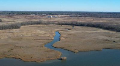
Nansemond National Wildlife Refuge is a protected nature reserve in Suffolk that combines salt marshes, grasslands, and forested stream corridors running along the Nansemond River. The landscape brings together different habitats that support diverse wildlife.

The refuge was established in 1973 when the US Navy transferred land to create this protected area. Additional acreage was added years later to expand the reserve's boundaries.

The refuge is named after the Nansemond Tribe, who lived in this river region long before English settlers arrived. This indigenous connection remains visible through the place's name and heritage.

The refuge is not open to public visits because it is located near military installations. Access to the grounds is restricted to protect both the area and the sensitive surroundings.

The refuge remains permanently closed to the public, which means it stays undisturbed as a safe place for migratory waterfowl. This complete isolation preserves it as a sanctuary for birds that avoid human activity.

The community of curious travelers

AroundUs brings together thousands of curated places, local tips, and hidden gems, enriched daily by 60,000 contributors worldwide.

Start exploring
Location
Inception
1973
Operator
United States Fish and Wildlife Service
GPS coordinates
36.81720,-76.55000
Latest update
December 13, 2025 12:41
Around this place
Monitor-Merrimac Memorial Bridge-Tunnel
United States of America

Monitor-Merrimac Memorial Bridge-Tunnel

19.1 km
Windsor Castle
United States of America

Windsor Castle

18.9 km
Newport News Middle Ground Light
United States of America

Newport News Middle Ground Light

20 km
Kings Highway Bridge
United States of America

Kings Highway Bridge

2.5 km
P. D. Gwaltney, Jr., House
United States of America

P. D. Gwaltney, Jr., House

19.6 km
Bay Point Farm
United States of America

Bay Point Farm

4.3 km
Nansemond River Bridge
United States of America

Nansemond River Bridge

9.3 km
Cedar Hill Cemetery
United States of America

Cedar Hill Cemetery

9.3 km
Riddick House
United States of America

Riddick House

9.4 km
Port Norfolk Historic District
United States of America

Port Norfolk Historic District

19.3 km
Suffolk Historic District
United States of America

Suffolk Historic District

10.1 km
Building at 216 Bank Street
United States of America

Building at 216 Bank Street

10.2 km
Phillips Farm
United States of America

Phillips Farm

7.4 km
Henry Saunders House
United States of America

Henry Saunders House

14.1 km
William Scott Farmstead
United States of America

William Scott Farmstead

14.1 km
Sunray Agricultural Historic District
United States of America

Sunray Agricultural Historic District

13 km
Chuckatuck Historic District
United States of America

Chuckatuck Historic District

5.5 km
Godwin-Knight House
United States of America

Godwin-Knight House

5.5 km
West End Historic District
United States of America

West End Historic District

10.6 km
East Suffolk Complex
United States of America

East Suffolk Complex

10.3 km
Professional Building
United States of America

Professional Building

10.4 km
Suffolk Peanut Company
United States of America

Suffolk Peanut Company

10.8 km
Phoenix Bank of Nansemond
United States of America

Phoenix Bank of Nansemond

10.4 km
Fort Nelson Chapter of the Daughters of the American Revolution Chapter House
United States of America

Fort Nelson Chapter of the Daughters of the American Revolution Chapter House

16.7 km
Driver Historic District
United States of America

Driver Historic District

4.3 km
Nansemond River Light
United States of America

Nansemond River Light

14.1 km
West Norfolk Bridge
United States of America

West Norfolk Bridge

18.8 km
Bide-A-Wee Golf Course
United States of America

Bide-A-Wee Golf Course

18.8 km
Show the full map
Reviews
Share your experience

No review yet

Discussions
Start a discussion...

No discussion yet

« Nansemond National Wildlife Refuge - National Wildlife Refuge in Suffolk, Virginia » is provided by Around Us (aroundus.com). Images and texts are derived from Wikimedia project under a Creative Commons license. You are allowed to copy, distribute, and modify copies of this page, under the conditions set by the license, as long as this note is clearly visible.

Discover hidden gems everywhere you go!

From secret cafés to breathtaking viewpoints, skip the crowded tourist spots and find places that match your style. Our app makes it easy with voice search, smart filtering, route optimization, and insider tips from travelers worldwide. Download now for the complete mobile experience.

Around Us App Screenshot

A unique approach to discovering new places

Le Figaro

All the places worth exploring

France Info

A tailor-made excursion in just a few clicks

20 Minutes

Around Us
Travel Guide & Maps
Download

Send to your phone

QR Code
1

Open the camera app on your mobile.

2

Point at the QR code with your camera. A notification will appear.

3

Tap the notification to open the link.