Enable Location

We need your location to show you interesting places around you

Discover nearby places

Find interesting locations and hidden gems around you

Precise directions

Get accurate directions and distances to places

Your location is never shared with other users. It's only used when you tap the location button.

Cedar Hill Cemetery

Log in to your account

Start exploring — it's free

Trusted by 61,681 travelers worldwide

Continue with Google
Continue with Apple
or

We will send you a code to connect

By continuing, you accept our Terms and Conditions and our Privacy Policy

Check your inbox

We've sent a pincode in your inbox. Please enter the code below.

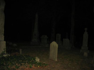
Cedar Hill Cemetery, 32-acre public cemetery in Suffolk, United States

Description

Cedar Hill Cemetery is a 32-acre public burial ground in Suffolk featuring rolling terrain dotted with cedar trees and an array of family mausoleums, stone monuments, and decorated graves. The grounds sit at the intersection of North Main Street and contain pathways that guide visitors through the different sections.

History

Established in 1802 as Green Hill Cemetery, the site has served as a burial ground for generations of Suffolk residents. It earned recognition on the National Register of Historic Places in 2006 for its significance to the region's architectural and historical heritage.

Culture

The cemetery serves as a repository of local identity, with burial sites honoring governors, military leaders, and service members who shaped Suffolk's past. Walking through it, you see how the community has marked the lives of those it considered important.

Practical

Visitors should follow memorial regulations that require floral vases instead of loose flowers and prohibit glass containers on the grounds. Parking is available only in designated areas, and only service animals are permitted to accompany visitors.

Did you know?

The grounds contain Suffolk's first scatter garden, a dedicated space enclosed by wrought-iron fencing with memorial plaques and benches for those choosing alternative burial options. This area reflects a different approach to memorialization compared to traditional grave markers.

Location
GPS coordinates
36.73750,-76.57970
Latest update
December 14, 2025 18:08

AroundUs brings together thousands of curated places, local tips, and hidden gems, enriched daily by 60,000 contributors worldwide. Discover all places nearby (Suffolk).

Around this place
Great Dismal Swamp National Wildlife Refuge
United States of America

Great Dismal Swamp National Wildlife Refuge

20.7 km
Nansemond National Wildlife Refuge
United States of America

Nansemond National Wildlife Refuge

9.3 km
Kings Highway Bridge
United States of America

Kings Highway Bridge

11.7 km
Bay Point Farm
United States of America

Bay Point Farm

13.2 km
Nansemond River Bridge
United States of America

Nansemond River Bridge

18.4 km
Riddick House
United States of America

Riddick House

259 m
Suffolk Historic District
United States of America

Suffolk Historic District

811 m
Holland Historic District (Suffolk, Virginia)
United States of America

Holland Historic District (Suffolk, Virginia)

18.5 km
Building at 216 Bank Street
United States of America

Building at 216 Bank Street

925 m
Phillips Farm
United States of America

Phillips Farm

15.6 km
Henry Saunders House
United States of America

Henry Saunders House

13.6 km
Wallaceton
United States of America

Wallaceton

22.6 km
William Scott Farmstead
United States of America

William Scott Farmstead

14.2 km
Sunray Agricultural Historic District
United States of America

Sunray Agricultural Historic District

15.8 km
Chuckatuck Historic District
United States of America

Chuckatuck Historic District

13.8 km
Godwin-Knight House
United States of America

Godwin-Knight House

13.8 km
Whaleyville Historic District
United States of America

Whaleyville Historic District

18.9 km
West End Historic District
United States of America

West End Historic District

1.6 km
East Suffolk Complex
United States of America

East Suffolk Complex

2 km
Professional Building
United States of America

Professional Building

1.1 km
Suffolk Peanut Company
United States of America

Suffolk Peanut Company

1.6 km
Nansemond County Training School
United States of America

Nansemond County Training School

22.8 km
Phoenix Bank of Nansemond
United States of America

Phoenix Bank of Nansemond

1.2 km
Fort Nelson Chapter of the Daughters of the American Revolution Chapter House
United States of America

Fort Nelson Chapter of the Daughters of the American Revolution Chapter House

22 km
Driver Historic District
United States of America

Driver Historic District

11.9 km
Zion Christian Church, Suffolk, Virginia
United States of America

Zion Christian Church, Suffolk, Virginia

15.5 km
Nansemond River Light
United States of America

Nansemond River Light

22.8 km
Bide-A-Wee Golf Course
United States of America

Bide-A-Wee Golf Course

22.6 km
Show the full map
« Cedar Hill Cemetery - 32-acre public cemetery in Suffolk, United States » is provided by Around Us (aroundus.com). Images and texts are derived from Wikimedia project under a Creative Commons license. You are allowed to copy, distribute, and modify copies of this page, under the conditions set by the license, as long as this note is clearly visible.

Discover hidden gems everywhere you go!

From secret cafés to breathtaking viewpoints, skip the crowded tourist spots and find places that match your style. Our app makes it easy with voice search, smart filtering, route optimization, and insider tips from travelers worldwide. Download now for the complete mobile experience.

Around Us App Screenshot

A unique approach to discovering new places

Le Figaro

All the places worth exploring

France Info

A tailor-made excursion in just a few clicks

20 Minutes

Around Us
Travel Guide & Maps
Download

Send to your phone

QR Code
1

Open the camera app on your mobile.

2

Point at the QR code with your camera. A notification will appear.

3

Tap the notification to open the link.