Kings Highway Bridge

Log in to your account

AroundUs is a community-driven map of interesting places, built by curious explorers like you. It grows with every review, story, and photo you share.
Connect to save your favorite spots, contribute locations, and create personalized routes.
Continue with Google
Continue with Apple
Continue with X
Continue with Facebook
Continue with email
By continuing, you accept our Terms and Conditions and our Privacy Policy
Create an account
Add to collection
Map
Suggest a change
Share

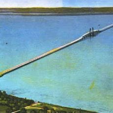
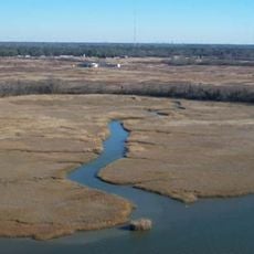
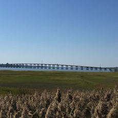
Kings Highway Bridge, Bascule bridge in Suffolk, Virginia.

Kings Highway Bridge is a bascule bridge spanning the Nansemond River in Suffolk and features a mechanical lifting system designed to allow boats and ships to pass underneath. The structure carried both car and truck traffic while accommodating water-based navigation on the same route.

The bridge opened in 1928 and provided a critical transportation link between the communities of Chuckatuck and Driver for many decades. Safety concerns eventually led to its closure in 2005.

For generations, this bridge connected the communities of Chuckatuck and Driver, forming an integral part of Suffolk's transportation network.

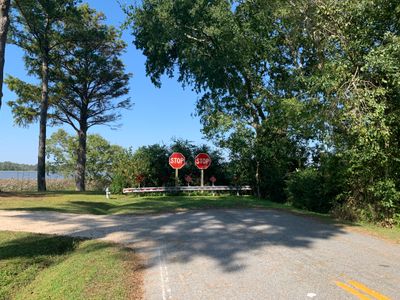
The bridge is closed to vehicle traffic, but you can view and photograph it from nearby roads and surrounding areas. Traffic has been redirected to alternative routes since the closure nearly two decades ago.

The original bridge was replaced by a new structure built about one kilometer south at Five Mile Road. The new facility was designed to meet modern safety standards and better serve the transportation needs of the region.

Location: Virginia

Official opening: 1928

GPS coordinates: 36.84000,-76.55000

Latest update: December 13, 2025 12:40

Photos
Around this place
Monitor-Merrimac Memorial Bridge-Tunnel
United States of America

Monitor-Merrimac Memorial Bridge-Tunnel

17.3 km
James River Bridge
United States of America

James River Bridge

17.8 km
Windsor Castle
United States of America

Windsor Castle

16.6 km
Nansemond National Wildlife Refuge
United States of America

Nansemond National Wildlife Refuge

2.5 km
P. D. Gwaltney, Jr., House
United States of America

P. D. Gwaltney, Jr., House

17.2 km
Smithfield Historic District
United States of America

Smithfield Historic District

17.4 km
Bay Point Farm
United States of America

Bay Point Farm

3 km
Nansemond River Bridge
United States of America

Nansemond River Bridge

7.3 km
Old Isle of Wight Courthouse
United States of America

Old Isle of Wight Courthouse

17.4 km
Cedar Hill Cemetery
United States of America

Cedar Hill Cemetery

11.7 km
Riddick House
United States of America

Riddick House

11.8 km
Suffolk Historic District
United States of America

Suffolk Historic District

12.5 km
Building at 216 Bank Street
United States of America

Building at 216 Bank Street

12.6 km
Phillips Farm
United States of America

Phillips Farm

5.2 km
Henry Saunders House
United States of America

Henry Saunders House

14.6 km
William Scott Farmstead
United States of America

William Scott Farmstead

14.4 km
Sunray Agricultural Historic District
United States of America

Sunray Agricultural Historic District

14 km
Isle of Wight County Museum
United States of America

Isle of Wight County Museum

17.4 km
Chuckatuck Historic District
United States of America

Chuckatuck Historic District

3.5 km
Godwin-Knight House
United States of America

Godwin-Knight House

3.4 km
West End Historic District
United States of America

West End Historic District

13 km
East Suffolk Complex
United States of America

East Suffolk Complex

12.9 km
Professional Building
United States of America

Professional Building

12.8 km
Suffolk Peanut Company
United States of America

Suffolk Peanut Company

13.3 km
Phoenix Bank of Nansemond
United States of America

Phoenix Bank of Nansemond

12.9 km
Fort Nelson Chapter of the Daughters of the American Revolution Chapter House
United States of America

Fort Nelson Chapter of the Daughters of the American Revolution Chapter House

16.6 km
Driver Historic District
United States of America

Driver Historic District

4.6 km
Wentworth-Grinnan House
United States of America

Wentworth-Grinnan House

17.4 km
Show the full map
Reviews

Visited this place? Tap the stars to rate it and share your experience / photos with the community! Try now! You can cancel it anytime.

« Kings Highway Bridge - Bascule bridge in Suffolk, Virginia » is provided by Around Us (aroundus.com). Images and texts are derived from Wikimedia project under a Creative Commons license. You are allowed to copy, distribute, and modify copies of this page, under the conditions set by the license, as long as this note is clearly visible.

Discover hidden gems everywhere you go!

From secret cafés to breathtaking viewpoints, skip the crowded tourist spots and find places that match your style. Our app makes it easy with voice search, smart filtering, route optimization, and insider tips from travelers worldwide. Download now for the complete mobile experience.

Around Us App Screenshot

A unique approach to discovering new places

Le Figaro

All the places worth exploring

France Info

A tailor-made excursion in just a few clicks

20 Minutes