Enable Location

We need your location to show you interesting places around you

Discover nearby places

Find interesting locations and hidden gems around you

Precise directions

Get accurate directions and distances to places

Your location is never shared with other users. It's only used when you tap the location button.

Moundsville Bridge

Log in to your account

Start exploring — it's free

Trusted by 61,868 travelers worldwide

Continue with Google
Continue with Apple
or

We will send you a code to connect

By continuing, you accept our Terms and Conditions and our Privacy Policy

Check your inbox

We've sent a pincode in your inbox. Please enter the code below.

Moundsville Bridge

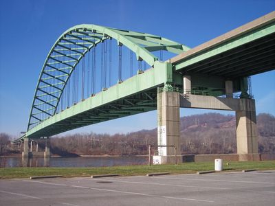
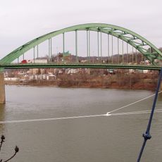
Moundsville Bridge, Road bridge between Moundsville, West Virginia and Mead Township, Ohio, United States

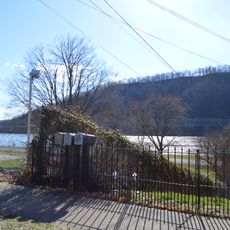
Moundsville Bridge is a four-lane road bridge crossing the Ohio River with a steel truss design connecting West Virginia to Ohio. The structure spans the river to join these two states at a strategic crossing point.

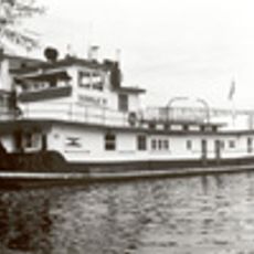
Construction started in the early 1970s with the bridge opening to traffic in November 1974. It replaced a ferry service that had operated across the river since 1951.

The bridge name honors former West Virginia governor Arch A. Moore Jr., and it stands in a region marked by Native American mounds and the imposing presence of the former state penitentiary nearby.

The bridge carries Ohio State Route 872 on one side and West Virginia Route 2 Spur on the other, serving as a busy regional link. Traffic can be heavy during peak hours, especially when weather conditions affect driving visibility.

Within its first year of operation, this bridge diverted so much traffic that a nearby toll bridge saw its revenue cut in half. The shift showed how dramatically the new route changed travel patterns across the Ohio River.

The community of curious travelers

AroundUs brings together thousands of curated places, local tips, and hidden gems, enriched daily by 60,000 contributors worldwide.

Start exploring
Location
Location
GPS coordinates
39.91330,-80.75420
Latest update
December 12, 2025 09:06
Around this place
West Virginia Penitentiary
United States of America

West Virginia Penitentiary

1.1 km
Grave Creek Mound
United States of America

Grave Creek Mound

905 m
Prabhupada's Palace of Gold
United States of America

Prabhupada's Palace of Gold

13.9 km
B & O Railroad Viaduct
United States of America

B & O Railroad Viaduct

11.1 km
Bellaire Bridge
United States of America

Bellaire Bridge

11.4 km
Wheeling Island Stadium
United States of America

Wheeling Island Stadium

16.9 km
West Virginia Independence Hall
United States of America

West Virginia Independence Hall

17 km
Interstate 470 Bridge
United States of America

Interstate 470 Bridge

15.3 km
Elm Grove Stone Arch Bridge
United States of America

Elm Grove Stone Arch Bridge

16.6 km
Center Wheeling Market
United States of America

Center Wheeling Market

16.4 km
Donald B.
United States of America

Donald B.

12.1 km
Chapline Street Row Historic District
United States of America

Chapline Street Row Historic District

16.5 km
Frederick Kindleberger Stone House and Barn
United States of America

Frederick Kindleberger Stone House and Barn

15.9 km
Centre Market Square Historic District
United States of America

Centre Market Square Historic District

16.5 km
Belleview Heights
United States of America

Belleview Heights

12.8 km
Highland Park Historic District (Wheeling, West Virginia)
United States of America

Highland Park Historic District (Wheeling, West Virginia)

17.2 km
Rock Hill Presbyterian Church
United States of America

Rock Hill Presbyterian Church

13.9 km
Bennett Cockayne House
United States of America

Bennett Cockayne House

3.3 km
Robert W. Hazlett House
United States of America

Robert W. Hazlett House

16.8 km
Zweig Building
United States of America

Zweig Building

11.8 km
Lang-Hess House
United States of America

Lang-Hess House

17.1 km
Riverside Iron Works Office Building
United States of America

Riverside Iron Works Office Building

17 km
Bushrod Washington Price House
United States of America

Bushrod Washington Price House

2.1 km
Moundsville Commercial Historic District
United States of America

Moundsville Commercial Historic District

1 km
Ferrell-Holt House
United States of America

Ferrell-Holt House

1.1 km
Imperial Glass Company
United States of America

Imperial Glass Company

10.9 km
La Belle Iron Works
United States of America

La Belle Iron Works

15.5 km
McMechen Lockmaster Houses on the Ohio River
United States of America

McMechen Lockmaster Houses on the Ohio River

8.6 km
Show the full map
« Moundsville Bridge - Road bridge between Moundsville, West Virginia and Mead Township, Ohio, United States » is provided by Around Us (aroundus.com). Images and texts are derived from Wikimedia project under a Creative Commons license. You are allowed to copy, distribute, and modify copies of this page, under the conditions set by the license, as long as this note is clearly visible.

Discover hidden gems everywhere you go!

From secret cafés to breathtaking viewpoints, skip the crowded tourist spots and find places that match your style. Our app makes it easy with voice search, smart filtering, route optimization, and insider tips from travelers worldwide. Download now for the complete mobile experience.

Around Us App Screenshot

A unique approach to discovering new places

Le Figaro

All the places worth exploring

France Info

A tailor-made excursion in just a few clicks

20 Minutes

Around Us
Travel Guide & Maps
Download

Send to your phone

QR Code
1

Open the camera app on your mobile.

2

Point at the QR code with your camera. A notification will appear.

3

Tap the notification to open the link.