Enable Location

We need your location to show you interesting places around you

Discover nearby places

Find interesting locations and hidden gems around you

Precise directions

Get accurate directions and distances to places

Your location is never shared with other users. It's only used when you tap the location button.

Devil's Bowl Speedway

Log in to your account

Start exploring — it's free

Trusted by 62,374 travelers worldwide

Continue with Google
Continue with Apple
or

We will send you a code to connect

By continuing, you accept our Terms and Conditions and our Privacy Policy

Check your inbox

We've sent a pincode in your inbox. Please enter the code below.

Devil's Bowl Speedway

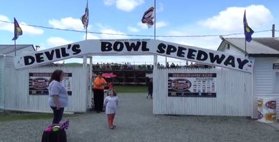
Devil's Bowl Speedway, tor wyścigowy (Stany Zjednoczone)

Devil's Bowl Speedway is a dirt racing track in Mesquite, Texas, shaped like a high-banked D and measuring half a mile in length. The track features challenging curves designed for high-speed racing, and spectators can feel the surface rumbling beneath their feet as cars zip past during competition.

Devil's Bowl Speedway has been part of the local sports scene for many years and holds significance in American motorsport history. The track was instrumental in the development of sprint car racing and served as the birthplace of the World of Outlaws series, establishing itself as a cornerstone of racing heritage.

Devil's Bowl Speedway holds deep roots in local racing culture, drawing fans who share a passion for sprint car competition and grassroots motorsport traditions. The track serves as a gathering place where spectators return year after year to experience camaraderie with fellow racing enthusiasts and witness drivers proving their skills on home ground.

The track is located just south of US 80 on Lawson Road and is easy to access with ample parking nearby and straightforward entry to the grandstands. Arriving early allows you to find a good viewing spot and watch cars being prepared before races begin.

The track frequently experiences weather-related cancellations, particularly from rain that forces races to be postponed. Despite these setbacks, the racing community remains dedicated, returning for rescheduled events and creating a tradition of persistence that defines the local racing experience.

The community of curious travelers

AroundUs brings together thousands of curated places, local tips, and hidden gems, enriched daily by 60,000 contributors worldwide.

Start exploring
GPS coordinates
43.66780,-73.29310
Latest update
February 7, 2026 11:40
Around this place
Vermont Marble Museum
United States of America

Vermont Marble Museum

20.8 km
Mount Independence
United States of America

Mount Independence

19 km
Skene Manor
United States of America

Skene Manor

15.1 km
Castleton Medical College Building
United States of America

Castleton Medical College Building

11.2 km
William Miller Chapel and Ascension Rock
United States of America

William Miller Chapel and Ascension Rock

8.3 km
Half Moon Pond State Park
United States of America

Half Moon Pond State Park

6.6 km
Gorham Covered Bridge
United States of America

Gorham Covered Bridge

20.6 km
Main Street Historic District
United States of America

Main Street Historic District

15.2 km
Hammond Covered Bridge
United States of America

Hammond Covered Bridge

20.1 km
Wilcox-Cutts House
United States of America

Wilcox-Cutts House

13.1 km
Fort Warren
United States of America

Fort Warren

11.9 km
South Street Bridge
United States of America

South Street Bridge

17.9 km
Sanderson Covered Bridge
United States of America

Sanderson Covered Bridge

19.9 km
Depot Covered Bridge
United States of America

Depot Covered Bridge

20.6 km
Dean Covered Bridge
United States of America

Dean Covered Bridge

20 km
First Congregational Church
United States of America

First Congregational Church

15.2 km
West Haven Baptist Church
United States of America

West Haven Baptist Church

4.8 km
Home Farm
United States of America

Home Farm

14.9 km
Chipman's Point
United States of America

Chipman's Point

16.1 km
Asahel Kidder House
United States of America

Asahel Kidder House

10.7 km
Fair Haven Green Historic District
United States of America

Fair Haven Green Historic District

8.6 km
Hydeville School
United States of America

Hydeville School

8.6 km
East Poultney Historic District
United States of America

East Poultney Historic District

17.3 km
Simeon Smith House
United States of America

Simeon Smith House

3.5 km
Sudbury School No. 3
United States of America

Sudbury School No. 3

15.9 km
Hiram Congdon House
United States of America

Hiram Congdon House

11.7 km
Poultney Main Street Historic District
United States of America

Poultney Main Street Historic District

17.4 km
William Miller Home
United States of America

William Miller Home

8.2 km
Show the full map
« Devil's Bowl Speedway - tor wyścigowy (Stany Zjednoczone) » is provided by Around Us (aroundus.com). Images and texts are derived from Wikimedia project under a Creative Commons license. You are allowed to copy, distribute, and modify copies of this page, under the conditions set by the license, as long as this note is clearly visible.

Discover hidden gems everywhere you go!

From secret cafés to breathtaking viewpoints, skip the crowded tourist spots and find places that match your style. Our app makes it easy with voice search, smart filtering, route optimization, and insider tips from travelers worldwide. Download now for the complete mobile experience.

Around Us App Screenshot

A unique approach to discovering new places

Le Figaro

All the places worth exploring

France Info

A tailor-made excursion in just a few clicks

20 Minutes

Around Us
Travel Guide & Maps
Download

Send to your phone

QR Code
1

Open the camera app on your mobile.

2

Point at the QR code with your camera. A notification will appear.

3

Tap the notification to open the link.