Enable Location

We need your location to show you interesting places around you

Discover nearby places

Find interesting locations and hidden gems around you

Precise directions

Get accurate directions and distances to places

Your location is never shared with other users. It's only used when you tap the location button.

Black Tern Bog State Natural Area

Log in to your account

Start exploring — it's free

Trusted by 62,935 travelers worldwide

Continue with Google
Continue with Apple
or

We will send you a code to connect

By continuing, you accept our Terms and Conditions and our Privacy Policy

Check your inbox

We've sent a pincode in your inbox. Please enter the code below.

Black Tern Bog State Natural Area
Discussion Reviews 1 Photos
1.4k Popularity

Black Tern Bog State Natural Area, Protected wetland area in Vilas County, Wisconsin, United States.

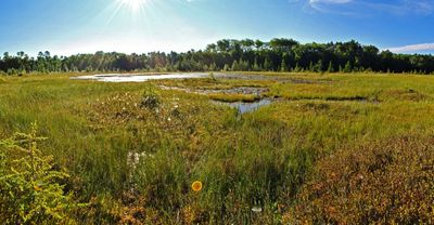
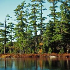
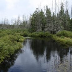
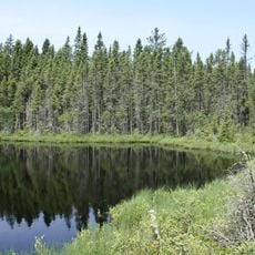
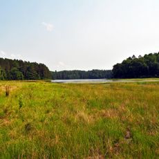
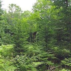
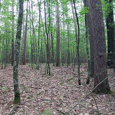
Black Tern Bog State Natural Area is a protected wetland in Wisconsin with sphagnum bog and two seepage lakes set within glacial terrain. The site features waterlogged conditions typical of bog ecosystems with flora adapted to saturated soils.

The site was designated in 1967 by the Wisconsin Department of Natural Resources to protect the bog landscapes of the region. This early conservation effort recognized the importance of these rare ecosystems before wetland protection became widespread.

The preservation of this wetland demonstrates Wisconsin's commitment to protecting natural environments that support native species and ecological diversity.

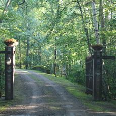
Access is via an unpaved road from US Highway 51, which circles the northern and eastern sections. Visitors should bring appropriate footwear for wet and soft terrain.

The area supports rare plant species including state-endangered bog rush and three orchid varieties. These specialized plants thrive only under the specific conditions of this bog ecosystem.

The community of curious travelers

AroundUs brings together thousands of curated places, local tips, and hidden gems, enriched daily by 60,000 contributors worldwide.

Start exploring
GPS coordinates
45.96701,-89.69809
Latest update
December 14, 2025 16:44
Around this place
Sylvania Wilderness
United States of America

Sylvania Wilderness

41.5 km
Lidice Memorial
United States of America

Lidice Memorial

62.8 km
United States of America

Northern Highland-American Legion State Forest

9.7 km
United States of America

Powell Marsh Wildlife Area

18.3 km
Headwaters Wilderness
United States of America

Headwaters Wilderness

60.4 km
Blackjack Springs Wilderness
United States of America

Blackjack Springs Wilderness

47.2 km
Eagle River Stadium
United States of America

Eagle River Stadium

38 km
Pioneer Park Historical Complex
United States of America

Pioneer Park Historical Complex

43.8 km
Sunset Point
United States of America

Sunset Point

40.5 km
Wind Pudding Lake State Natural Area
United States of America

Wind Pudding Lake State Natural Area

23.5 km
Franklin Lake Campground
United States of America

Franklin Lake Campground

54.7 km
Oneida County Courthouse
United States of America

Oneida County Courthouse

43.1 km
Annala Round Barn
United States of America

Annala Round Barn

61.6 km
Jersey City Flowage
United States of America

Jersey City Flowage

53.1 km
Rice Creek State Natural Area
United States of America

Rice Creek State Natural Area

22.3 km
Solon and Mathilda Sutliff House
United States of America

Solon and Mathilda Sutliff House

43 km
Fifield Fire Lookout Tower
United States of America

Fifield Fire Lookout Tower

49.3 km
First National Bank
United States of America

First National Bank

42.8 km
Fifield Town Hall
United States of America

Fifield Town Hall

56.9 km
Bose Lake Hemlock Hardwoods
United States of America

Bose Lake Hemlock Hardwoods

56.3 km
Finnerud Forest Scientific Area
United States of America

Finnerud Forest Scientific Area

12.7 km
Lake Gogebic State Park
United States of America

Lake Gogebic State Park

55.4 km
PPHC - Railroad Museum
United States of America

PPHC - Railroad Museum

43.6 km
Lake Gogebic
United States of America

Lake Gogebic

60 km
Main Street – Black River Bridge
United States of America

Main Street – Black River Bridge

61 km
State Theatre
United States of America

State Theatre

42.7 km
Smith Rapids Covered Bridge
United States of America

Smith Rapids Covered Bridge

37.2 km
James W. Toumey Nursery
United States of America

James W. Toumey Nursery

53 km
Show the full map
Reviews
Share your experience

No review yet

Discussions
Start a discussion...

No discussion yet

« Black Tern Bog State Natural Area - Protected wetland area in Vilas County, Wisconsin, United States » is provided by Around Us (aroundus.com). Images and texts are derived from Wikimedia project under a Creative Commons license. You are allowed to copy, distribute, and modify copies of this page, under the conditions set by the license, as long as this note is clearly visible.

Discover hidden gems everywhere you go!

From secret cafés to breathtaking viewpoints, skip the crowded tourist spots and find places that match your style. Our app makes it easy with voice search, smart filtering, route optimization, and insider tips from travelers worldwide. Download now for the complete mobile experience.

Around Us App Screenshot

A unique approach to discovering new places

Le Figaro

All the places worth exploring

France Info

A tailor-made excursion in just a few clicks

20 Minutes

Around Us
Travel Guide & Maps
Download

Send to your phone

QR Code
1

Open the camera app on your mobile.

2

Point at the QR code with your camera. A notification will appear.

3

Tap the notification to open the link.