Headwaters Wilderness

Log in to your account

AroundUs is a community-driven map of interesting places, built by curious explorers like you. It grows with every review, story, and photo you share.
Connect to save your favorite spots, contribute locations, and create personalized routes.
Continue with Google
Continue with Apple
Continue with X
Continue with Facebook
Continue with email
By continuing, you accept our Terms and Conditions and our Privacy Policy
Create an account
Add to collection
Map
Suggest a change
Share

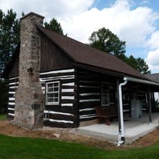
Headwaters Wilderness, Wilderness area in Forest County, Wisconsin, United States.

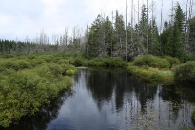
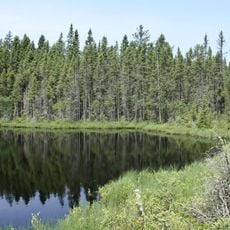
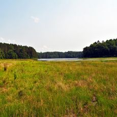
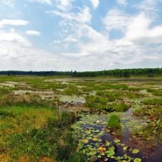
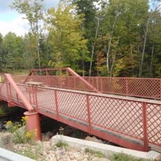
Headwaters Wilderness is a forested protected area of over 22,000 acres containing swampland, bogs, and pine forests within the Chequamegon-Nicolet National Forest in northeastern Wisconsin. The land is crossed by primitive hiking trails and offers hunting, fishing, and wildlife viewing opportunities.

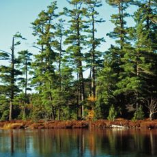
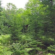
The area was designated for protection in 1984 and forms part of the Nicolet National Forest. It contains some of the oldest eastern white pine stands in Wisconsin, which took many decades to grow.

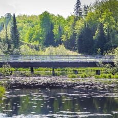
The river and its tributaries flow through an area that holds ecological importance for nearby communities and supports many animal species. Visitors can experience firsthand how local nature depends on healthy waterways.

Access is via primitive trails that require care when navigating, especially in wet conditions across bogs and swampland. Sturdy hiking boots, maps, and plenty of water are important to bring along.

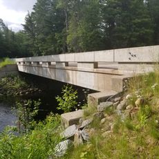
The area contains the source springs of the Pine River, a protected wild river flowing eastward into Michigan's Upper Peninsula. This pristine water source holds special significance for paddlers and anglers.

Location: Forest County

GPS coordinates: 45.81410,-88.95070

Latest update: December 12, 2025 17:44

Photos
Around this place
Sylvania Wilderness
United States of America

Sylvania Wilderness

52.2 km
Iron County MRA
United States of America

Iron County MRA

47.2 km
Bewabic State Park
United States of America

Bewabic State Park

50.6 km
United States of America

Lumberjack Steam Train

35 km
Blackjack Springs Wilderness
United States of America

Blackjack Springs Wilderness

20.9 km
Eagle River Stadium
United States of America

Eagle River Stadium

23.1 km
Pioneer Park Historical Complex
United States of America

Pioneer Park Historical Complex

34 km
Camp Five Museum
United States of America

Camp Five Museum

33.2 km
Sunset Point
United States of America

Sunset Point

20.5 km
Central School
United States of America

Central School

39.3 km
Wind Pudding Lake State Natural Area
United States of America

Wind Pudding Lake State Natural Area

53.3 km
Grandma Lake Wetlands State Natural Area
United States of America

Grandma Lake Wetlands State Natural Area

26.2 km
Franklin Lake Campground
United States of America

Franklin Lake Campground

13.4 km
Dinesen-Motzfeldt-Hettinger Log House
United States of America

Dinesen-Motzfeldt-Hettinger Log House

36.4 km
Oneida County Courthouse
United States of America

Oneida County Courthouse

40.6 km
Solon and Mathilda Sutliff House
United States of America

Solon and Mathilda Sutliff House

40.5 km
First National Bank
United States of America

First National Bank

40.8 km
Armstrong Creek Bridge
United States of America

Armstrong Creek Bridge

43.7 km
Forest Route 157–Tamarack River Bridge
United States of America

Forest Route 157–Tamarack River Bridge

48.3 km
Bose Lake Hemlock Hardwoods
United States of America

Bose Lake Hemlock Hardwoods

13.2 km
Fern School
United States of America

Fern School

43.8 km
Chicago and North-Western Land Office
United States of America

Chicago and North-Western Land Office

47.4 km
Chicagon Mine Road–Chicagon Creek Bridge
United States of America

Chicagon Mine Road–Chicagon Creek Bridge

46.4 km
Lumberjack Steam Train & Camp 5 Museum
United States of America

Lumberjack Steam Train & Camp 5 Museum

34.9 km
PPHC - Railroad Museum
United States of America

PPHC - Railroad Museum

40.9 km
State Theatre
United States of America

State Theatre

40.8 km
M 189 / W 139 Highway Bridge over Brule River
United States of America

M 189 / W 139 Highway Bridge over Brule River

30.1 km
James W. Toumey Nursery
United States of America

James W. Toumey Nursery

53.7 km
Show the full map
Reviews

Visited this place? Tap the stars to rate it and share your experience / photos with the community! Try now! You can cancel it anytime.

« Headwaters Wilderness - Wilderness area in Forest County, Wisconsin, United States » is provided by Around Us (aroundus.com). Images and texts are derived from Wikimedia project under a Creative Commons license. You are allowed to copy, distribute, and modify copies of this page, under the conditions set by the license, as long as this note is clearly visible.

Discover hidden gems everywhere you go!

From secret cafés to breathtaking viewpoints, skip the crowded tourist spots and find places that match your style. Our app makes it easy with voice search, smart filtering, route optimization, and insider tips from travelers worldwide. Download now for the complete mobile experience.

Around Us App Screenshot

A unique approach to discovering new places

Le Figaro

All the places worth exploring

France Info

A tailor-made excursion in just a few clicks

20 Minutes