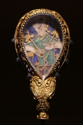
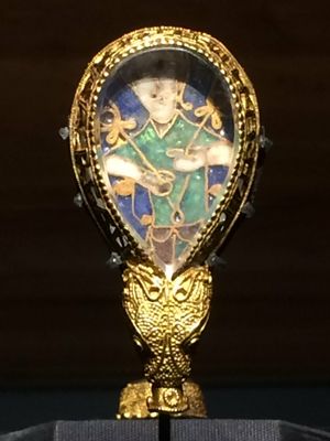
Alfred Jewel, Anglo-Saxon archaeological treasure in Oxford, England
The Alfred Jewel is a small ornamental object made of gold, quartz, and enamel, shaped with a dragon head at one end. It was designed as a wearable reading pointer to help mark places in religious texts and was likely commissioned by an Anglo-Saxon king.
The object was likely made in the ninth century and bears an inscription in Old English naming an Anglo-Saxon king. It was discovered in 1693 near Athelney in Somerset, more than a thousand years after it was originally crafted.
The jewel shows how Anglo-Saxon craftspeople mastered the combination of gold, crystal, and enamel to create objects of lasting beauty and purpose. It reflects a society where such carefully made items belonged to powerful figures and held meaning in their daily routines.
At the Ashmolean Museum in Oxford, this small treasure can be viewed up close in a display case. Allow time to study the fine details and engraved inscription carefully, as the object is quite small.
The inscription on this piece is written in Old English and directly names the person who commissioned it. This makes it a rare example of a medieval object where its origin is so clearly documented.
Inception: 9 century
Height: 6.2 cm
Width: 3.1 cm
Made from material: gold, vitreous enamel, quartz
Website: https://ashmolean.org/alfred-jewel
GPS coordinates: 51.37469,-2.44072
Latest update: December 14, 2025 20:53
Newton Park
198 m
Kelston Park
2.2 km
Newton St Loe Castle
78 m
Stantonbury Camp
2.2 km
Culverhay Castle
2.8 km
Church of St Peter, Englishcombe
2.5 km
Church of the Holy Trinity, Newton St Loe
1.1 km
Newton St Loe SSSI
2.7 km
Church of St Lawrence, Stanton Prior
2.1 km
Priston Mill And Attached Pond, Dam And Walls
2.5 km
Church of All Saints
1.2 km
The Cottage
1.7 km
The Turnpike
2.5 km
Boundary Post At Ngr St 6967 6527
1.2 km
The Old Rectory And Garden Walls And Gatepiers To The West
1.1 km
Boundary Marker At St 6914 6621
2.2 km
Twerton Wood Tunnel West Portal
2.7 km
Tithe Barn Attached To South End Of Rectory Farmhouse
2.5 km
Milestone At National Grid Reference St 6973 6579
1.8 km
Milestone At National Grid Reference St 7085 6638
2.7 km
Milestone At National Grid Reference St 6924 6520
1.1 km
Manor Farmhouse
1.1 km
Barn And Attached Farm Buildings About 30 Metres South East Of Poplar Farm
1.8 km
Newbridge Railway Bridge
2.8 km
Park Farmhouse
758 m
Poplar Farmhouse
1.9 km
Milestone, eastbound carriageway, between Globe Inn, Corston and jct with A36
1.9 km
Milestone, E of Stantonbury House and Wheatsheaf PH, W of Corston
1.8 kmVisited this place? Tap the stars to rate it and share your experience / photos with the community! Try now! You can cancel it anytime.
Discover hidden gems everywhere you go!
From secret cafés to breathtaking viewpoints, skip the crowded tourist spots and find places that match your style. Our app makes it easy with voice search, smart filtering, route optimization, and insider tips from travelers worldwide. Download now for the complete mobile experience.
A unique approach to discovering new places❞
— Le Figaro
All the places worth exploring❞
— France Info
A tailor-made excursion in just a few clicks❞
— 20 Minutes