King Doniert's Stone

Log in to your account

AroundUs is a community-driven map of interesting places, built by curious explorers like you. It grows with every review, story, and photo you share.
Connect to save your favorite spots, contribute locations, and create personalized routes.
By continuing, you accept our Terms and Conditions and our Privacy Policy
Add to collection
Map
Suggest a change
Share

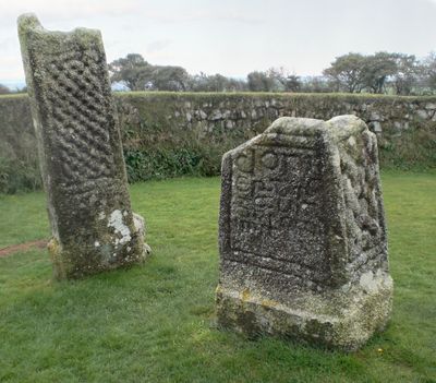
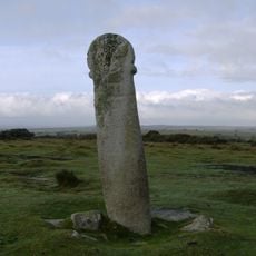
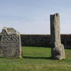
King Doniert's Stone, Archaeological site in Cornwall, England

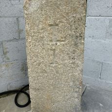
King Doniert's Stone is an archaeological monument in Cornwall consisting of two cross-decorated stone fragments from the 9th century. The pieces are intricately carved and show the skilled stonework typical of this early medieval period.

The stones were erected as a memorial to Dungarth, the last independent ruler of Cornwall, who drowned around 875 AD. This site preserves the memory of when independent rule ended in this region.

The name connects to King Doniert, a figure who held importance in local memory and tradition. The way these stone crosses stand here shows how Celtic and Christian traditions came together in this region.

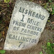
The site is free to visit and accessible during daylight hours, with parking available in a nearby layby. Access to the stones is straightforward and reached without difficulty.

Hidden beneath the visible crosses lies an underground chamber with a cross shape, discovered during excavations in the 1800s. This underground structure reveals that more lies beneath what visitors see at the surface.

Location: Cornwall

Inception: 9 century

Website: https://english-heritage.org.uk/visit/places/king-donierts-stone

GPS coordinates: 50.49280,-4.48817

Latest update: December 6, 2025 17:47

Photos
Hidden locations in Cornwall

Cornwall holds scattered coves, historic manors, and ancient stone circles that together create a collection of places reflecting the region's history, culture, and landscape. Visitors can discover medieval castles like Tintagel Castle, climb lighthouses, explore underground caves, and walk through...

Around this place
Hurlers Stone Circles
United Kingdom

Hurlers Stone Circles

3.4 km
Trethevy Quoit
United Kingdom

Trethevy Quoit

2.3 km
Rillaton Barrow
United Kingdom

Rillaton Barrow

3.9 km
Craddock Moor stone circle
United Kingdom

Craddock Moor stone circle

3.2 km
Guildhall
United Kingdom

Guildhall

4.6 km
Church of St Clarus
United Kingdom

Church of St Clarus

1.4 km
Treverbyn Old Bridge
United Kingdom

Treverbyn Old Bridge

3.3 km
The White Horse Public House
United Kingdom

The White Horse Public House

4.5 km
Golitha Falls
United Kingdom

Golitha Falls

1.1 km
Fountain
United Kingdom

Fountain

4.5 km
The Longstone medieval wayside cross 750m SW of Minions
United Kingdom

The Longstone medieval wayside cross 750m SW of Minions

2.6 km
St Cleer Holy Well
United Kingdom

St Cleer Holy Well

1.4 km
Prince Of Wales Engine House At Phoenix United Mine
United Kingdom

Prince Of Wales Engine House At Phoenix United Mine

4.3 km
Milestone 200 Metres South East Of Straches
United Kingdom

Milestone 200 Metres South East Of Straches

4.2 km
Medieval wayside cross at Wenmouth Cross, 320m north of Wenmouth
United Kingdom

Medieval wayside cross at Wenmouth Cross, 320m north of Wenmouth

4.1 km
Guidestone, Treworgey Manor drive to house
United Kingdom

Guidestone, Treworgey Manor drive to house

2.3 km
Milestone At Sx 2632 6554
United Kingdom

Milestone At Sx 2632 6554

4.3 km
Treworgey Retaining Walls To Main Drive
United Kingdom

Treworgey Retaining Walls To Main Drive

2.4 km
Treweatha Farmhouse
United Kingdom

Treweatha Farmhouse

2.4 km
Milestone At Sx 2542 6595
United Kingdom

Milestone At Sx 2542 6595

3.4 km
Milestone At Sx 2659 6707
United Kingdom

Milestone At Sx 2659 6707

3.5 km
The Doniert Stone, accompanying cross shaft and underground chamber 650m SW of Common Moor
United Kingdom

The Doniert Stone, accompanying cross shaft and underground chamber 650m SW of Common Moor

7 m
Milestone To South Of Nos 3 And 4 Dean Terrace
United Kingdom

Milestone To South Of Nos 3 And 4 Dean Terrace

4.4 km
Milestone At Higher Roscraddoc (Ngr Sx2753367900)
United Kingdom

Milestone At Higher Roscraddoc (Ngr Sx2753367900)

4 km
The Toll House
United Kingdom

The Toll House

4 km
Milestone At Sx 2249 6597 To North West Of Woodhill Manor
United Kingdom

Milestone At Sx 2249 6597 To North West Of Woodhill Manor

3 km
The Hurlers: three stone circles with paired outlying stones
United Kingdom

The Hurlers: three stone circles with paired outlying stones

3.4 km
The Crow's Nest
United Kingdom

The Crow's Nest

2.8 km
Show the full map
Reviews

Visited this place? Tap the stars to rate it and share your experience / photos with the community! Try now! You can cancel it anytime.

« King Doniert's Stone - Archaeological site in Cornwall, England » is provided by Around Us (aroundus.com). Images and texts are derived from Wikimedia project under a Creative Commons license. You are allowed to copy, distribute, and modify copies of this page, under the conditions set by the license, as long as this note is clearly visible.

Discover hidden gems everywhere you go!

From secret cafés to breathtaking viewpoints, skip the crowded tourist spots and find places that match your style. Our app makes it easy with voice search, smart filtering, route optimization, and insider tips from travelers worldwide. Download now for the complete mobile experience.

Around Us App Screenshot

A unique approach to discovering new places

Le Figaro

All the places worth exploring

France Info

A tailor-made excursion in just a few clicks

20 Minutes