Golitha Falls

Log in to your account

AroundUs is a community-driven map of interesting places, built by curious explorers like you. It grows with every review, story, and photo you share.
Connect to save your favorite spots, contribute locations, and create personalized routes.
By continuing, you accept our Terms and Conditions and our Privacy Policy

Golitha Falls

Add to collection
Map
Suggest a change
Share

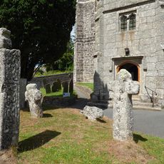
Golitha Falls, Waterfall series in Cornwall, England

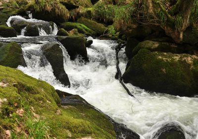
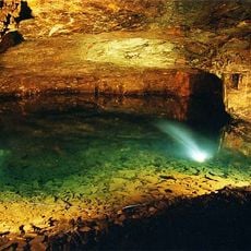
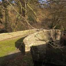
Golitha Falls is a series of cascades in Draynes Wood where the River Fowey drops 90 meters as it cuts through the woodland. The water tumbles over moss-covered rocks and creates a string of pools separated by smaller drops along its path.

The woodland has evolved naturally over centuries and remains an important refuge for native plant and animal species. The waterfalls themselves are the product of long-term erosion as the river continually cuts through the surrounding rock.

The locality is known among nature enthusiasts as a place where flowing water shapes the character of the woodland throughout the seasons. People come here to experience the interplay between moving water and ancient trees that define the landscape.

A parking area near Draynes Bridge provides access to walking trails that lead through the woodland to the falls. The paths can be muddy or slippery, especially after rain, so proper footwear is advisable.

The woodland supports an exceptional diversity of mosses and lichens, with more than 120 moss species thriving on the damp rocks. The forest also provides habitat for specialized wildlife including bats and dormice that depend on these rare woodland conditions.

Location: Cornwall

GPS coordinates: 50.48929,-4.50288

Latest update: December 6, 2025 19:07

Photos
Hidden locations in Cornwall

Cornwall holds scattered coves, historic manors, and ancient stone circles that together create a collection of places reflecting the region's history, culture, and landscape. Visitors can discover medieval castles like Tintagel Castle, climb lighthouses, explore underground caves, and walk through...

Around this place
Hurlers Stone Circles
United Kingdom

Hurlers Stone Circles

4.4 km
Trethevy Quoit
United Kingdom

Trethevy Quoit

3.4 km
Carnglaze Caverns
United Kingdom

Carnglaze Caverns

4.2 km
Craddock Moor stone circle
United Kingdom

Craddock Moor stone circle

4.1 km
King Doniert's Stone
United Kingdom

King Doniert's Stone

1.1 km
Church of St Clarus
United Kingdom

Church of St Clarus

2.2 km
Church of St Anietus
United Kingdom

Church of St Anietus

4 km
Treverbyn Old Bridge
United Kingdom

Treverbyn Old Bridge

2.2 km
The White Horse Public House
United Kingdom

The White Horse Public House

4.7 km
The Longstone medieval wayside cross 750m SW of Minions
United Kingdom

The Longstone medieval wayside cross 750m SW of Minions

3.6 km
Milestone West Of Doublebois (Ngr Sx1957564908)
United Kingdom

Milestone West Of Doublebois (Ngr Sx1957564908)

4.7 km
Milestone 200 Metres South East Of Straches
United Kingdom

Milestone 200 Metres South East Of Straches

3.5 km
Fountain
United Kingdom

Fountain

4.6 km
Medieval wayside cross at Wenmouth Cross, 320m north of Wenmouth
United Kingdom

Medieval wayside cross at Wenmouth Cross, 320m north of Wenmouth

3 km
St Cleer Holy Well
United Kingdom

St Cleer Holy Well

2.4 km
Guidestone, Treworgey Manor drive to house
United Kingdom

Guidestone, Treworgey Manor drive to house

2.5 km
The Doniert Stone, accompanying cross shaft and underground chamber 650m SW of Common Moor
United Kingdom

The Doniert Stone, accompanying cross shaft and underground chamber 650m SW of Common Moor

1.1 km
Treworgey Retaining Walls To Main Drive
United Kingdom

Treworgey Retaining Walls To Main Drive

2.5 km
Churchyard cross and three wayside crosses in St Neot churchyard
United Kingdom

Churchyard cross and three wayside crosses in St Neot churchyard

4 km
Milestone At Sx 2542 6595
United Kingdom

Milestone At Sx 2542 6595

3.8 km
Milestone At Sx 2659 6707
United Kingdom

Milestone At Sx 2659 6707

4.3 km
Milestone At Sx 2249 6597 To North West Of Woodhill Manor
United Kingdom

Milestone At Sx 2249 6597 To North West Of Woodhill Manor

3.2 km
Milestone To South Of Nos 3 And 4 Dean Terrace
United Kingdom

Milestone To South Of Nos 3 And 4 Dean Terrace

4.5 km
The Crow's Nest
United Kingdom

The Crow's Nest

3.9 km
Milepost West Of Railway Bridge (Ngr Sx2052164801)
United Kingdom

Milepost West Of Railway Bridge (Ngr Sx2052164801)

4.2 km
The Toll House
United Kingdom

The Toll House

3.7 km
Treweatha Farmhouse
United Kingdom

Treweatha Farmhouse

1.4 km
The Hurlers: three stone circles with paired outlying stones
United Kingdom

The Hurlers: three stone circles with paired outlying stones

4.4 km
Show the full map
Reviews

Visited this place? Tap the stars to rate it and share your experience / photos with the community! Try now! You can cancel it anytime.

« Golitha Falls - Waterfall series in Cornwall, England » is provided by Around Us (aroundus.com). Images and texts are derived from Wikimedia project under a Creative Commons license. You are allowed to copy, distribute, and modify copies of this page, under the conditions set by the license, as long as this note is clearly visible.

Discover hidden gems everywhere you go!

From secret cafés to breathtaking viewpoints, skip the crowded tourist spots and find places that match your style. Our app makes it easy with voice search, smart filtering, route optimization, and insider tips from travelers worldwide. Download now for the complete mobile experience.

Around Us App Screenshot

A unique approach to discovering new places

Le Figaro

All the places worth exploring

France Info

A tailor-made excursion in just a few clicks

20 Minutes