Enable Location

We need your location to show you interesting places around you

Discover nearby places

Find interesting locations and hidden gems around you

Precise directions

Get accurate directions and distances to places

Your location is never shared with other users. It's only used when you tap the location button.

Tregiffian Burial Chamber

Log in to your account

Start exploring — it's free

Trusted by 62,000 travelers worldwide

Continue with Google
Continue with Apple
or

We will send you a code to connect

By continuing, you accept our Terms and Conditions and our Privacy Policy

Check your inbox

We've sent a pincode in your inbox. Please enter the code below.

Tregiffian Burial Chamber

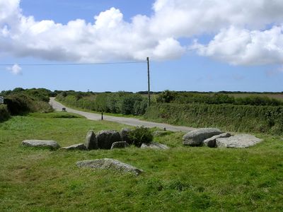
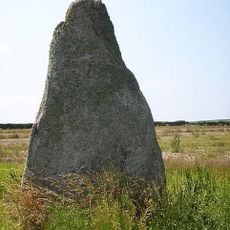
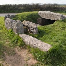
Tregiffian Burial Chamber, Neolithic burial chamber near Lamorna, Cornwall.

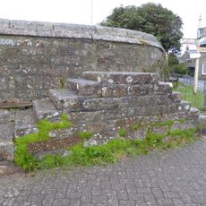
Tregiffian Burial Chamber is a prehistoric stone chamber located near Lamorna that served as a tomb for the dead. The main burial space stretches about 5 meters long and is built from large slabs of stone held together without mortar.

The chamber was built between 3000 and 2000 BC and held the remains of multiple cremated individuals from that era. The structure was modified and adapted as burial practices shifted during the transition from the Neolithic to the Bronze Age.

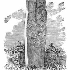
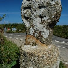
The entrance stone displays 25 artificial hollows called cupmarks, showing how early people left their mark on stone. These markings offer a direct window into prehistoric artistic practice.

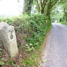
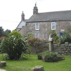
You can reach the site by parking at the Merry Maidens layby on the B3315 road and following a short walking path to the chamber. The location is easy to access on foot and the terrain presents no major obstacles.

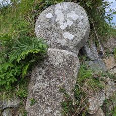
The original stone decorated with cupmarks is kept safely in the Royal Cornwall Museum in Truro. A precise cast replica of this stone stands at the burial site so visitors can see the carved details.

The community of curious travelers

AroundUs brings together thousands of curated places, local tips, and hidden gems, enriched daily by 60,000 contributors worldwide.

Start exploring
Location
GPS coordinates
50.06435,-5.59195
Latest update
December 14, 2025 09:42
Around this place
The Merry Maidens
United Kingdom

The Merry Maidens

243 m
Boscawen-Un
United Kingdom

Boscawen-Un

3.4 km
Tater Du Lighthouse
United Kingdom

Tater Du Lighthouse

1.8 km
St Buryan's Church
United Kingdom

St Buryan's Church

2.5 km
St Loy's Cove
United Kingdom

St Loy's Cove

1.5 km
Boleigh Fogou
United Kingdom

Boleigh Fogou

1 km
The Pipers
United Kingdom

The Pipers

642 m
Round, courtyard house, stone hut circle settlement and field system 275m north of Castallack Carn
United Kingdom

Round, courtyard house, stone hut circle settlement and field system 275m north of Castallack Carn

2 km
Standing stone known as the 'Blind Fiddler', 405m south east of Lesbew Farm
United Kingdom

Standing stone known as the 'Blind Fiddler', 405m south east of Lesbew Farm

3.8 km
Tresvennack Pillar
United Kingdom

Tresvennack Pillar

3.6 km
Barn Immediately North Of The Logan Rock Inn
United Kingdom

Barn Immediately North Of The Logan Rock Inn

3.9 km
Milestone Approximately 135M Se Of The Firs
United Kingdom

Milestone Approximately 135M Se Of The Firs

3.8 km
Milestone At Sw 43110 28029, 87M North-East Of Lower Hendra Cottages
United Kingdom

Milestone At Sw 43110 28029, 87M North-East Of Lower Hendra Cottages

3.6 km
Guide Post At Sw 401248
United Kingdom

Guide Post At Sw 401248

3 km
Churchyard Walls And Adjoining War Memorial
United Kingdom

Churchyard Walls And Adjoining War Memorial

2.5 km
Boskenna Gate Cross
United Kingdom

Boskenna Gate Cross

1.1 km
Kerris Manor Farmhouse Including Front Garden Walls And Rear Courtyard Walls
United Kingdom

Kerris Manor Farmhouse Including Front Garden Walls And Rear Courtyard Walls

3 km
Mounting Block Near South Gateway Of Churchyard Of Church Of St Buryan
United Kingdom

Mounting Block Near South Gateway Of Churchyard Of Church Of St Buryan

2.5 km
Boskenna Cross
United Kingdom

Boskenna Cross

493 m
Old Farmhouse And Adjoining Outbuilding At Approximately 15 Metres North Of Treen Farmhouse
United Kingdom

Old Farmhouse And Adjoining Outbuilding At Approximately 15 Metres North Of Treen Farmhouse

3.8 km
Churchyard cross in St Buryan churchyard
United Kingdom

Churchyard cross in St Buryan churchyard

2.5 km
Kerris Cross
United Kingdom

Kerris Cross

3 km
Cross At Sw4611725135 (Kemyel Drea Cross)
United Kingdom

Cross At Sw4611725135 (Kemyel Drea Cross)

3.2 km
Guide Post At Sw400247
United Kingdom

Guide Post At Sw400247

3 km
Guide Post At Sw399241
United Kingdom

Guide Post At Sw399241

3.2 km
Prehistoric entrance grave 900m north west of Tregiffian Farm
United Kingdom

Prehistoric entrance grave 900m north west of Tregiffian Farm

9 m
St Buryan churchtown cross
United Kingdom

St Buryan churchtown cross

2.5 km
Cross at SW419242
United Kingdom

Cross at SW419242

1.1 km
Show the full map
« Tregiffian Burial Chamber - Neolithic burial chamber near Lamorna, Cornwall » is provided by Around Us (aroundus.com). Images and texts are derived from Wikimedia project under a Creative Commons license. You are allowed to copy, distribute, and modify copies of this page, under the conditions set by the license, as long as this note is clearly visible.

Discover hidden gems everywhere you go!

From secret cafés to breathtaking viewpoints, skip the crowded tourist spots and find places that match your style. Our app makes it easy with voice search, smart filtering, route optimization, and insider tips from travelers worldwide. Download now for the complete mobile experience.

Around Us App Screenshot

A unique approach to discovering new places

Le Figaro

All the places worth exploring

France Info

A tailor-made excursion in just a few clicks

20 Minutes

Around Us
Travel Guide & Maps
Download

Send to your phone

QR Code
1

Open the camera app on your mobile.

2

Point at the QR code with your camera. A notification will appear.

3

Tap the notification to open the link.