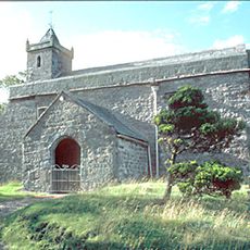
St Oswald's Church, Ravenstonedale, Grade I listed Anglican church in Ravenstonedale, England.
St Oswald's Church is a neoclassical church building constructed from rubble stone with slate roofing and an eight-bay nave. It features a three-stage west tower with a doorway as its main entrance.
The church was built in 1738, replacing an earlier Norman structure and reusing materials from the previous building. The site has a longer religious history extending back to the medieval period.
The interior with its pews facing the center of the nave follows a college chapel arrangement, creating an unusual layout for a parish church. The three-decker pulpit on the north side emphasizes this distinctive design.
The building is well-maintained from outside and holds Grade I listed status, with the churchyard accessible to visitors. Be aware that the three historic bells in the tower are not currently functional for ringing.
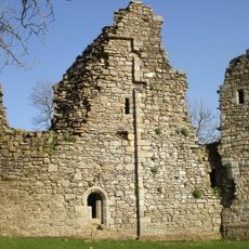
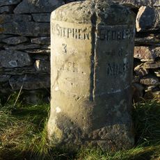
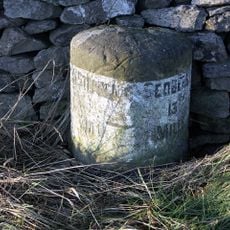
The churchyard holds ruins of a 13th-century Gilbertine Priory, showing the area's medieval monastic past. A pre-Norman cross-shaft stands nearby alongside a brass sundial plate dated 1700.
Location: Ravenstonedale
Inception: 1738
Architectural style: Neoclassical architecture
Website: http://ravenstonedale.org/churches/oswalds
GPS coordinates: 54.43300,-2.42960
Latest update: December 14, 2025 15:00
Crosby Garrett Helmet
5.2 km
Pendragon Castle
6.2 km
Wild Boar Fell
6.5 km
Wharton Hall
5.2 km
Yarlside
6.8 kmDevil's Grinding Mill
6 km
St Andrew's Church, Crosby Garrett
5.5 km
Ravenstonedale Priory
35 m
Smardale Gill Viaduct
2.7 km
Green Bell
4 km
Stainmore Railway Company
5.7 km
Milestone 150 Yards North East Of Methodist Chapel (Ngr 724 995)
4.8 km
Lammerside Castle
5 km
Smardale Bridge
1.7 km
Rawthey Bridge
6.5 km
Kirkby Stephen War Memorial
6.9 km
The Old Rectory
5.4 km
Barn To North East Of Old Rectory
5.4 km
Crosby Garrett Viaduct at NT 727 093
5.1 km
Milestone Opposite Tarn House (At Ngr Ny 749 034)
2.8 km
Cross shaft base and sundial 10 yards to south of church
21 m
Boundary Stone To East Of White Brackens House (Nateby Parish)
5.5 km
Smardale Railway Viaduct
4.1 km
Milestone 850 Yards To North East Of Studfold (At Ngr 734 007)
3.7 km
Milestone Circa 250 Yards To West Of Brig Cottage (At Ngr 716 981)
6.2 km
Smardale Hall and adjoining buildings
4.2 km
Milestone, Wharton Fell, a mile S of jct with A685
3.7 km
Milestone, Nateby, N of Kirkby Stephen station
5.4 kmVisited this place? Tap the stars to rate it and share your experience / photos with the community! Try now! You can cancel it anytime.
Discover hidden gems everywhere you go!
From secret cafés to breathtaking viewpoints, skip the crowded tourist spots and find places that match your style. Our app makes it easy with voice search, smart filtering, route optimization, and insider tips from travelers worldwide. Download now for the complete mobile experience.
A unique approach to discovering new places❞
— Le Figaro
All the places worth exploring❞
— France Info
A tailor-made excursion in just a few clicks❞
— 20 Minutes