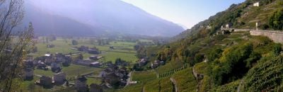
Teglio, Italian comune
Location: Province of Sondrio
Capital city: Teglio
Elevation above the sea: 851 m
Website: http://www.comune.teglio.so.it
Shares border with: Aprica, Bianzone, Castello dell'Acqua, Chiuro, Corteno Golgi, Paisco Loveno, Ponte in Valtellina, Schilpario, Valbondione, Vilminore di Scalve, Villa di Tirano, Brusio
Website: http://comune.teglio.so.it
GPS coordinates: 46.16667,10.06667
Latest update: March 10, 2025 01:55
Cascate del Serio
11.9 km
Pizzo Coca
11.4 km
Bandora
613 m
Lago del Barbellino
11.4 km
Palazzo Besta
615 m
Monte Gleno
12.7 km
Monte Torena
9.1 km
Pizzo del Diavolo della Malgina
9.2 km
Pizzo Recastello
12.2 km
Palazzo Salis
10 km
Tirano
9.5 km
Sant'Eufemia
592 m
Pizzo Strinato
10.9 km
Monte Venerocolo
14.5 km
Monte Trobio
12 km
San Martino church
10 km
Museo Etnografico Tiranese
8.9 km
Cime di Caronella
8.5 km
Town fortification of Tirano
10.2 km
San Rocco (Tirano)
9.2 km
Riserva naturale Pian Gembro
7 km
Castle of Saint Mary
9.6 km
Mariano Spasmo (Tirano)
9.7 km
Sant'Agostino (Tirano)
9.9 km
Sacro Cuore (Tirano)
9.6 km
Chiesa dell Angelo Custode
10.1 km
Santo Stefano
10 km
Madonna di Tirano
8.9 kmReviews
Visited this place? Tap the stars to rate it and share your experience / photos with the community! Try now! You can cancel it anytime.
Discover hidden gems everywhere you go!
From secret cafés to breathtaking viewpoints, skip the crowded tourist spots and find places that match your style. Our app makes it easy with voice search, smart filtering, route optimization, and insider tips from travelers worldwide. Download now for the complete mobile experience.
A unique approach to discovering new places❞
— Le Figaro
All the places worth exploring❞
— France Info
A tailor-made excursion in just a few clicks❞
— 20 Minutes