Enable Location

We need your location to show you interesting places around you

Discover nearby places

Find interesting locations and hidden gems around you

Precise directions

Get accurate directions and distances to places

Your location is never shared with other users. It's only used when you tap the location button.

Kolpaki

Log in to your account

Start exploring — it's free

Trusted by 62,486 travelers worldwide

Continue with Google
Continue with Apple
or

We will send you a code to connect

By continuing, you accept our Terms and Conditions and our Privacy Policy

Check your inbox

We've sent a pincode in your inbox. Please enter the code below.

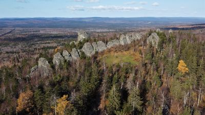
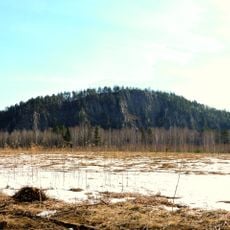
Kolpaki, upland in Perm Krai, Russia

Kolpaki is a protected upland area in Gornozavodsky District, Perm Krai, defined by rocky outcrops and forested slopes. The terrain features weathered stone formations rising from a landscape of pine trees, moss, and fallen leaves, with trails winding through the uneven ground.

The site received official protection in 1981 to preserve its natural features and local ecosystems. The region has remained largely undeveloped, maintaining its wild character and serving as a quiet retreat for visitors seeking connection with the land.

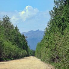
Access is best by vehicle as public transportation is limited; dirt roads lead to the base of the upland. Wear sturdy hiking boots and a jacket since terrain is uneven and conditions can change quickly, with no facilities available on site.

The rocky formations take their name from rounded, dome-like peaks that resemble small caps or crowns. These shapes were carved over time by wind and rain, creating natural stone sculptures that stand out against the forest backdrop.

The community of curious travelers

AroundUs brings together thousands of curated places, local tips, and hidden gems, enriched daily by 60,000 contributors worldwide.

Start exploring
Location
Inception
April 28, 1981
GPS coordinates
58.61556,59.18222
Latest update
February 7, 2026 11:40
Around this place
Uralskaya Superdeep Borehole
Russian Federation

Uralskaya Superdeep Borehole

41.4 km
Bshad sgrub gling
Russian Federation

Bshad sgrub gling

21.5 km
Blagodat
Russian Federation

Blagodat

50.6 km
Medved kamen
Russian Federation

Medved kamen

77.8 km
Nizhne Turinskiy Prud
Russian Federation

Nizhne Turinskiy Prud

37.3 km
Verkhne-Vyyskiy Prud
Russian Federation

Verkhne-Vyyskiy Prud

83.8 km
Gornyak Stadium
Russian Federation

Gornyak Stadium

19.1 km
Sinyaya
Russian Federation

Sinyaya

59.9 km
Кусье-Александровский завод
Russian Federation

Кусье-Александровский завод

59.5 km
Church of Icon of the Mother of God «Seeking the Lost»
Russian Federation

Church of Icon of the Mother of God «Seeking the Lost»

19.7 km
Upper Kachkanar Reservoir
Russian Federation

Upper Kachkanar Reservoir

14.6 km
Park Stroiteley
Russian Federation

Park Stroiteley

20.4 km
Kachkanar Historical and Local History Museum
Russian Federation

Kachkanar Historical and Local History Museum

19.2 km
Pashiysky Metallurgical and Cement Plant
Russian Federation

Pashiysky Metallurgical and Cement Plant

57.4 km
Upper Tura Reservoir
Russian Federation

Upper Tura Reservoir

46.5 km
Kushvinskiy Prud
Russian Federation

Kushvinskiy Prud

50.5 km
Lower Kachkanar Reservoir
Russian Federation

Lower Kachkanar Reservoir

18.6 km
Prometheus Park in Kachkanar
Russian Federation

Prometheus Park in Kachkanar

19.6 km
Glavniy quarry of Kachkanarsky GOK
Russian Federation

Glavniy quarry of Kachkanarsky GOK

24.2 km
Severniy quarry of Kachkanarsky GOK
Russian Federation

Severniy quarry of Kachkanarsky GOK

25.3 km
Saint Alexander Nevsky Church
Russian Federation

Saint Alexander Nevsky Church

45.9 km
KGOK administrative building
Russian Federation

KGOK administrative building

20.4 km
Administration of Kachkanar district
Russian Federation

Administration of Kachkanar district

20.2 km
Tailings of Kachkanarskiy mining and processing plant
Russian Federation

Tailings of Kachkanarskiy mining and processing plant

24.6 km
Oslyanka
Russian Federation

Oslyanka

71.1 km
Zapadniy quarry of Kachkanarsky GOK
Russian Federation

Zapadniy quarry of Kachkanarsky GOK

23.3 km
Orlyonok, Young Pioneer Camp
Russian Federation

Orlyonok, Young Pioneer Camp

15.2 km
Vyisky Technical Pond
Russian Federation

Vyisky Technical Pond

23 km
Show the full map
« Kolpaki - upland in Perm Krai, Russia » is provided by Around Us (aroundus.com). Images and texts are derived from Wikimedia project under a Creative Commons license. You are allowed to copy, distribute, and modify copies of this page, under the conditions set by the license, as long as this note is clearly visible.

Discover hidden gems everywhere you go!

From secret cafés to breathtaking viewpoints, skip the crowded tourist spots and find places that match your style. Our app makes it easy with voice search, smart filtering, route optimization, and insider tips from travelers worldwide. Download now for the complete mobile experience.

Around Us App Screenshot

A unique approach to discovering new places

Le Figaro

All the places worth exploring

France Info

A tailor-made excursion in just a few clicks

20 Minutes

Around Us
Travel Guide & Maps
Download

Send to your phone

QR Code
1

Open the camera app on your mobile.

2

Point at the QR code with your camera. A notification will appear.

3

Tap the notification to open the link.