Chest opened
+${chestReward.xp} XP
Explorer
NOUVEAU ×${chestReward.collectible.quantity}
tapez pour fermer
Chest locked

Open chests in the app

Around Us is built for your phone — chests unlock when you walk, explore and capture nearby places.

Enable Location

We need your location to show you interesting places around you

Discover nearby places

Find interesting locations and hidden gems around you

Precise directions

Get accurate directions and distances to places

Your location is never shared with other users. It's only used when you tap the location button.

Log in to your account

Start exploring — it's free

Trusted by 72,918 travelers worldwide

Continue with Google
Continue with Apple
or

We will send you a code to connect

By continuing, you accept our Terms and Conditions and our Privacy Policy

Check your inbox

We've sent a pincode in your inbox. Please enter the code below.

Council Point Park
Discussion Reviews Photo
2.3k Popularity

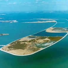
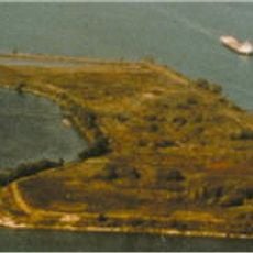
Council Point Park, Urban park in Lincoln Park, Michigan

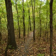
Council Point Park is an urban recreational area with walking paths and sports fields situated along a waterway in Michigan. The grounds feature two play areas for children, baseball and soccer fields, shaded picnic spots, and parking access from the main road.

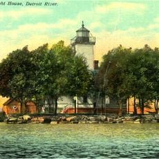
This location served as a council gathering place in the 18th century before the landscape was transformed into a public park in modern times. The early meeting ground reflects a significant moment in regional conflicts during that era.

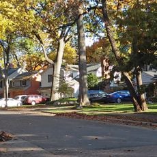
Local residents use the sports fields for neighborhood games and tournaments, while the riverside paths serve as meeting places for dog walkers and neighbors who come regularly. The open areas function as gathering spaces where people of different ages move through the landscape together.

The park is easy to reach by car from the nearby main road and has dedicated parking areas near the entrance. Walking paths vary in terrain and difficulty, so choose a route that matches your fitness level and time available.

Two branches of the river meet and merge at this specific location before continuing downstream. This natural junction point is often overlooked by visitors who focus mainly on the walking paths.

The community of curious travelers

AroundUs brings together thousands of curated places, local tips, and hidden gems, enriched daily by 60,000 contributors worldwide.

Start exploring
Location
GPS coordinates
42.23556,-83.16194
Latest update
December 13, 2025 12:24
Around this place
Uniroyal Giant Tire
United States of America

Uniroyal Giant Tire

5.5 km
Fort Wayne
United States of America

Fort Wayne

8.9 km
Ford Rotunda
United States of America

Ford Rotunda

8.6 km
Dearborn Mosque
United States of America

Dearborn Mosque

7.8 km
Ste. Claire
United States of America

Ste. Claire

4.2 km
Detroit River International Wildlife Refuge
United States of America

Detroit River International Wildlife Refuge

3.2 km
Gateway Bridge
United States of America

Gateway Bridge

9.5 km
Grosse Ile Toll Bridge
United States of America

Grosse Ile Toll Bridge

7 km
Ford Rouge Factory Tour
United States of America

Ford Rouge Factory Tour

9.5 km
West Jefferson Avenue–Rouge River Bridge
United States of America

West Jefferson Avenue–Rouge River Bridge

5.7 km
Grassy Island
United States of America

Grassy Island

2.7 km
Henry Ford Centennial Library
United States of America

Henry Ford Centennial Library

9.3 km
George P. MacNichol House
United States of America

George P. MacNichol House

3.3 km
Ojibway Prairie Complex
Canada

Ojibway Prairie Complex

8 km
Ford-Bacon House
United States of America

Ford-Bacon House

3.3 km
Sandwich First Baptist Church
Canada

Sandwich First Baptist Church

9.2 km
Marx House
United States of America

Marx House

3.3 km
Fort Street–Pleasant Street and Norfolk & Western Railroad Viaduct
United States of America

Fort Street–Pleasant Street and Norfolk & Western Railroad Viaduct

5.6 km
Dearborn City Hall Complex
United States of America

Dearborn City Hall Complex

9.6 km
Mellus Newspapers Building
United States of America

Mellus Newspapers Building

2.1 km
John and Emma Lacey Eberts House
United States of America

John and Emma Lacey Eberts House

3.3 km
Wyandotte Odd Fellows Temple
United States of America

Wyandotte Odd Fellows Temple

3.5 km
Grassy Island Light
United States of America

Grassy Island Light

2.7 km
Black Oak Heritage Park
Canada

Black Oak Heritage Park

7 km
Parke Lane Road–Thorofare Canal Bridge
United States of America

Parke Lane Road–Thorofare Canal Bridge

7.7 km
Springwells Park Historic District
United States of America

Springwells Park Historic District

8.5 km
Fort Wayne
United States of America

Fort Wayne

8.7 km
R.P. McMurphy's
United States of America

R.P. McMurphy's

3.7 km
Show the full map
Reviews
Share your experience

No review yet

Discussions
Start a discussion...

No discussion yet

« Council Point Park - Urban park in Lincoln Park, Michigan » is provided by Around Us (aroundus.com). Images and texts are derived from Wikimedia project under a Creative Commons license. You are allowed to copy, distribute, and modify copies of this page, under the conditions set by the license, as long as this note is clearly visible.

Discover hidden gems everywhere you go!

From secret cafés to breathtaking viewpoints, skip the crowded tourist spots and find places that match your style. Our app makes it easy with voice search, smart filtering, route optimization, and insider tips from travelers worldwide. Download now for the complete mobile experience.

Around Us App Screenshot

A unique approach to discovering new places

Le Figaro

All the places worth exploring

France Info

A tailor-made excursion in just a few clicks

20 Minutes

Around Us
Travel Guide & Maps
Download

Send to your phone

QR Code
1

Open the camera app on your mobile.

2

Point at the QR code with your camera. A notification will appear.

3

Tap the notification to open the link.