Enable Location

We need your location to show you interesting places around you

Discover nearby places

Find interesting locations and hidden gems around you

Precise directions

Get accurate directions and distances to places

Your location is never shared with other users. It's only used when you tap the location button.

Five Channels Dam

Log in to your account

Start exploring — it's free

Trusted by 61,909 travelers worldwide

Continue with Google
Continue with Apple
or

We will send you a code to connect

By continuing, you accept our Terms and Conditions and our Privacy Policy

Check your inbox

We've sent a pincode in your inbox. Please enter the code below.

Five Channels Dam, Historic hydroelectric dam in Iosco County, Michigan, United States

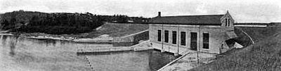
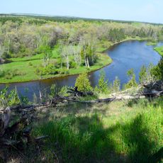
Five Channels Dam is a hydroelectric dam crossing the Au Sable River with spillway gates and a large reservoir behind it. The structure holds back water that creates opportunities for recreation and power generation.

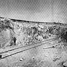
The dam was built between 1911 and 1912 as part of a larger chain of six hydroelectric plants along the lower Au Sable River. Construction required a temporary workers settlement that supported the project during those years.

The dam structure represents early 20th-century engineering methods as the second of six hydroelectric plants built along the lower Au Sable River system.

The reservoir offers fishing access for multiple fish species at different spots along the banks and water edges. A portage slide system allows canoeists and kayakers to safely navigate around the dam.

The site preserves a portage slide system that allows watercraft to safely bypass the dam and continue downstream. This system shows how early engineers accommodated canoe travel while generating power.

The community of curious travelers

AroundUs brings together thousands of curated places, local tips, and hidden gems, enriched daily by 60,000 contributors worldwide.

Start exploring
Location
GPS coordinates
44.45530,-83.67660
Latest update
December 13, 2025 12:41
Around this place
Lumberman's Monument
United States of America

Lumberman's Monument

4.7 km
Thunder Bay National Marine Sanctuary
United States of America

Thunder Bay National Marine Sanctuary

69.6 km
Sturgeon Point Light
United States of America

Sturgeon Point Light

42.8 km
Tawas Point State Park
United States of America

Tawas Point State Park

28.8 km
Harrisville State Park
United States of America

Harrisville State Park

37.1 km
Au Sable State Forest
United States of America

Au Sable State Forest

55.8 km
Tawas Point Light
United States of America

Tawas Point Light

28.8 km
Negwegon State Park
United States of America

Negwegon State Park

52.5 km
Charity Island Light
United States of America

Charity Island Light

50.2 km
Alpena Light
United States of America

Alpena Light

70.3 km
Port Austin Light
United States of America

Port Austin Light

69.1 km
Gravelly Shoal Light
United States of America

Gravelly Shoal Light

49.9 km
Alabaster Historic District
United States of America

Alabaster Historic District

31.1 km
United States of America

Temple Beth El

69.9 km
Roscommon Zoo
United States of America

Roscommon Zoo

64.5 km
Eggleston School
United States of America

Eggleston School

70 km
Oscoda County Courthouse
United States of America

Oscoda County Courthouse

41.9 km
Ogemaw Hills Pathway
United States of America

Ogemaw Hills Pathway

45.2 km
Bingham School
United States of America

Bingham School

70.1 km
Second Arenac County Courthouse
United States of America

Second Arenac County Courthouse

47.6 km
Dinosaur Gardens
United States of America

Dinosaur Gardens

54.5 km
Caseville Harbor Light
United States of America

Caseville Harbor Light

64.9 km
White Pine National
United States of America

White Pine National

35.5 km
Wurtsmith Air Museum
United States of America

Wurtsmith Air Museum

25.4 km
CoopersVille USA
United States of America

CoopersVille USA

62.1 km
Au Sable National Scenic River
United States of America

Au Sable National Scenic River

31.5 km
Kiwanis Monument
United States of America

Kiwanis Monument

5.3 km
Rollways Campground and Day Use Area
United States of America

Rollways Campground and Day Use Area

7.7 km
Show the full map
« Five Channels Dam - Historic hydroelectric dam in Iosco County, Michigan, United States » is provided by Around Us (aroundus.com). Images and texts are derived from Wikimedia project under a Creative Commons license. You are allowed to copy, distribute, and modify copies of this page, under the conditions set by the license, as long as this note is clearly visible.

Discover hidden gems everywhere you go!

From secret cafés to breathtaking viewpoints, skip the crowded tourist spots and find places that match your style. Our app makes it easy with voice search, smart filtering, route optimization, and insider tips from travelers worldwide. Download now for the complete mobile experience.

Around Us App Screenshot

A unique approach to discovering new places

Le Figaro

All the places worth exploring

France Info

A tailor-made excursion in just a few clicks

20 Minutes

Around Us
Travel Guide & Maps
Download

Send to your phone

QR Code
1

Open the camera app on your mobile.

2

Point at the QR code with your camera. A notification will appear.

3

Tap the notification to open the link.