Sturgeon Point Light

Log in to your account

AroundUs is a community-driven map of interesting places, built by curious explorers like you. It grows with every review, story, and photo you share.
Connect to save your favorite spots, contribute locations, and create personalized routes.
Continue with Google
Continue with Apple
Continue with X
Continue with Facebook
Continue with email
By continuing, you accept our Terms and Conditions and our Privacy Policy
Create an account
Add to collection
Map
Suggest a change
Share

Sturgeon Point Light, Maritime navigation lighthouse in Alcona County, United States

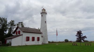
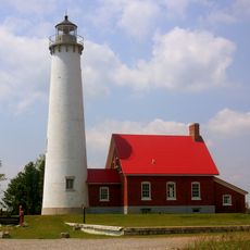
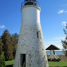
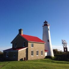
Sturgeon Point Light is a brick lighthouse marking a treacherous reef in Lake Huron, standing about 22 meters tall with a large Fresnel lens. The structure sits on a rocky point and includes a keeper's house and museum building adjacent to the tower.

Built in 1869, the lighthouse was constructed to guide ships through dangerous waters during Michigan's timber and commerce boom on the Great Lakes. It served as a critical aid for captains navigating this section of Lake Huron.

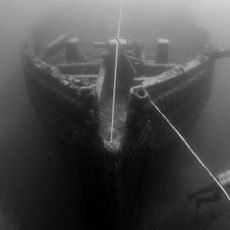
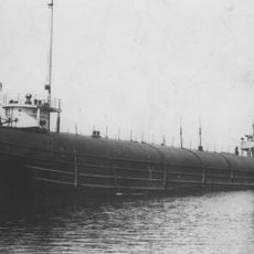
The lighthouse houses a maritime museum displaying artifacts and ship components that document how people navigated and traded on the Great Lakes. These collections show the practical tools and knowledge that shaped waterborne life in the region.

The lighthouse is open to visitors from June through September with guided tours available during the full season and weekends in transition months. Wear sturdy shoes for climbing the narrow tower stairs, and plan to spend about an hour exploring both the tower and museum exhibits.

The tower retains its original Cape Cod architectural style with a white finish and red roof accents that still stand out against the shoreline. Inside, the operational Fresnel lens of its size remains relatively uncommon among American lighthouses still in service.

Location: Alcona County

Location: Haynes Township

Inception: 1869

Architects: United States Lighthouse Board

Height: 22 m

Made from material: brick

GPS coordinates: 44.71000,-83.27222

Latest update: December 6, 2025 17:42

Photos
Michigan natural and historic sites

Michigan holds a wide array of natural and historical sites across its two peninsulas. The shoreline runs for hundreds of miles along the Great Lakes, showing sand beaches, rocky cliffs, and dune formations. In the north, dense forests, waterfalls, and rock formations shaped by erosion dominate the...

Around this place
Lumberman's Monument
United States of America

Lumberman's Monument

41.4 km
Thunder Bay National Marine Sanctuary
United States of America

Thunder Bay National Marine Sanctuary

32.7 km
SS Clifton
United States of America

SS Clifton

68 km
Tawas Point State Park
United States of America

Tawas Point State Park

52.4 km
Harrisville State Park
United States of America

Harrisville State Park

7.2 km
Tawas Point Light
United States of America

Tawas Point Light

52.7 km
Old Presque Isle Light
United States of America

Old Presque Isle Light

72.2 km
Negwegon State Park
United States of America

Negwegon State Park

16.8 km
Rockport State Recreation Area
United States of America

Rockport State Recreation Area

55.4 km
Alpena Light
United States of America

Alpena Light

40.8 km
Alabaster Historic District
United States of America

Alabaster Historic District

62.8 km
Five Channels Dam
United States of America

Five Channels Dam

42.8 km
Thunder Bay Island Light
United States of America

Thunder Bay Island Light

36.9 km
United States of America

Temple Beth El

41 km
Alpena County Courthouse
United States of America

Alpena County Courthouse

42 km
Middle Island Light
United States of America

Middle Island Light

53.9 km
Oscoda County Courthouse
United States of America

Oscoda County Courthouse

68.2 km
Leer Lutheran Church
United States of America

Leer Lutheran Church

64.7 km
Katherine V.
United States of America

Katherine V.

43.6 km
Bingham School
United States of America

Bingham School

41.5 km
Dinosaur Gardens
United States of America

Dinosaur Gardens

26.5 km
Great Lakes Maritime Heritage Center
United States of America

Great Lakes Maritime Heritage Center

41.9 km
White Pine National
United States of America

White Pine National

19.7 km
Wurtsmith Air Museum
United States of America

Wurtsmith Air Museum

28.8 km
Au Sable National Scenic River
United States of America

Au Sable National Scenic River

55.6 km
Kiwanis Monument
United States of America

Kiwanis Monument

42.1 km
Second Avenue Bridge
United States of America

Second Avenue Bridge

41.3 km
Rollways Campground and Day Use Area
United States of America

Rollways Campground and Day Use Area

48.6 km
Show the full map
Reviews

Visited this place? Tap the stars to rate it and share your experience / photos with the community! Try now! You can cancel it anytime.

« Sturgeon Point Light - Maritime navigation lighthouse in Alcona County, United States » is provided by Around Us (aroundus.com). Images and texts are derived from Wikimedia project under a Creative Commons license. You are allowed to copy, distribute, and modify copies of this page, under the conditions set by the license, as long as this note is clearly visible.

Discover hidden gems everywhere you go!

From secret cafés to breathtaking viewpoints, skip the crowded tourist spots and find places that match your style. Our app makes it easy with voice search, smart filtering, route optimization, and insider tips from travelers worldwide. Download now for the complete mobile experience.

Around Us App Screenshot

A unique approach to discovering new places

Le Figaro

All the places worth exploring

France Info

A tailor-made excursion in just a few clicks

20 Minutes