Enable Location

We need your location to show you interesting places around you

Discover nearby places

Find interesting locations and hidden gems around you

Precise directions

Get accurate directions and distances to places

Your location is never shared with other users. It's only used when you tap the location button.

Fort Massapeag Archeological Site

Log in to your account

Start exploring — it's free

Trusted by 63,045 travelers worldwide

Continue with Google
Continue with Apple
or

We will send you a code to connect

By continuing, you accept our Terms and Conditions and our Privacy Policy

Check your inbox

We've sent a pincode in your inbox. Please enter the code below.

Discussion Reviews 1 Photos
1.5k Popularity

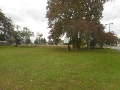
Fort Massapeag Archeological Site, Archaeological site in Massapequa, New York, United States.

Fort Massapeag is an archaeological site in Sunset Park that preserves the remains of a fortified settlement from the 17th century. The excavation areas show defensive ditches, foundation remnants, and other structures that reveal what the former trading station looked like.

The site was established in 1656 by Peter Stuyvesant, a Dutch colonial administrator, as a trading post. Its founding rested on an agreement with Lenape leader Tackapausha to facilitate commerce with Native American peoples.

The location reveals how different peoples coexisted and traded for centuries in this space. Visitors can observe the physical traces of this shared history through the excavated foundations and settlement patterns visible across the park.

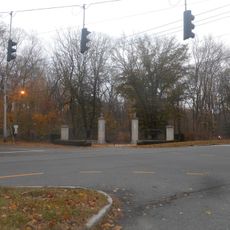
The site is located in Sunset Park and can be reached near Fairfax Road and Gloucester Road. It received National Historic Landmark recognition in 1993 and remains open to the public for exploring the archaeological remains.

The site served as a wampum production center where Native American artisans crafted shell bead currency. This manufacturing activity made the location economically vital to the colonial trade networks of the era.

The community of curious travelers

AroundUs brings together thousands of curated places, local tips, and hidden gems, enriched daily by 60,000 contributors worldwide.

Start exploring
Location
GPS coordinates
40.86667,-73.53333
Latest update
December 14, 2025 15:02
Around this place
Planting Fields Arboretum State Historic Park
United States of America

Planting Fields Arboretum State Historic Park

2.1 km
Youngs Memorial Cemetery
United States of America

Youngs Memorial Cemetery

2.3 km
Sagamore Hill
United States of America

Sagamore Hill

3.7 km
Raynham Hall Museum
United States of America

Raynham Hall Museum

641 m
Theodore Roosevelt Memorial Park
United States of America

Theodore Roosevelt Memorial Park

975 m
Knollwood Estate
United States of America

Knollwood Estate

4.6 km
Oyster Bay National Wildlife Refuge
United States of America

Oyster Bay National Wildlife Refuge

3.5 km
Christeen
United States of America

Christeen

1.3 km
Benjamin Moore Estate
United States of America

Benjamin Moore Estate

3.1 km
United States of America

Bayville Bridge

4.2 km
Cold Spring Harbor Whaling Museum
United States of America

Cold Spring Harbor Whaling Museum

6.7 km
Cold Spring Harbor Light
United States of America

Cold Spring Harbor Light

6.3 km
Sagamore Hill
United States of America

Sagamore Hill

3.4 km
Moore's Building
United States of America

Moore's Building

717 m
Cold Spring Harbor Library
United States of America

Cold Spring Harbor Library

6.1 km
Hood A.M.E. Zion Church
United States of America

Hood A.M.E. Zion Church

545 m
Wilson House
United States of America

Wilson House

747 m
Seely/Wright House
United States of America

Seely/Wright House

606 m
Council Rock
United States of America

Council Rock

1 km
Derby-Hall Bandstand
United States of America

Derby-Hall Bandstand

784 m
Main Street Historic District
United States of America

Main Street Historic District

6.5 km
Oyster Bay Bank Building
United States of America

Oyster Bay Bank Building

721 m
Shore Road Historic District
United States of America

Shore Road Historic District

6 km
Fleet's Hall
United States of America

Fleet's Hall

999 m
Harbor Road Historic District
United States of America

Harbor Road Historic District

6.1 km
Ludlam Building
United States of America

Ludlam Building

625 m
Roosevelt Museum at Old Orchard
United States of America

Roosevelt Museum at Old Orchard

3.8 km
Coe Hall
United States of America

Coe Hall

2.1 km
Show the full map
Reviews
Share your experience

No review yet

Discussions
Start a discussion...

No discussion yet

« Fort Massapeag Archeological Site - Archaeological site in Massapequa, New York, United States » is provided by Around Us (aroundus.com). Images and texts are derived from Wikimedia project under a Creative Commons license. You are allowed to copy, distribute, and modify copies of this page, under the conditions set by the license, as long as this note is clearly visible.

Discover hidden gems everywhere you go!

From secret cafés to breathtaking viewpoints, skip the crowded tourist spots and find places that match your style. Our app makes it easy with voice search, smart filtering, route optimization, and insider tips from travelers worldwide. Download now for the complete mobile experience.

Around Us App Screenshot

A unique approach to discovering new places

Le Figaro

All the places worth exploring

France Info

A tailor-made excursion in just a few clicks

20 Minutes

Around Us
Travel Guide & Maps
Download

Send to your phone

QR Code
1

Open the camera app on your mobile.

2

Point at the QR code with your camera. A notification will appear.

3

Tap the notification to open the link.