Enable Location

We need your location to show you interesting places around you

Discover nearby places

Find interesting locations and hidden gems around you

Precise directions

Get accurate directions and distances to places

Your location is never shared with other users. It's only used when you tap the location button.

I-35W Minnesota River bridge

Log in to your account

Start exploring — it's free

Trusted by 62,921 travelers worldwide

Continue with Google
Continue with Apple
or

We will send you a code to connect

By continuing, you accept our Terms and Conditions and our Privacy Policy

Check your inbox

We've sent a pincode in your inbox. Please enter the code below.

I-35W Minnesota River bridge
Discussion Reviews 1 Photos
1.5k Popularity

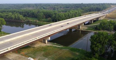
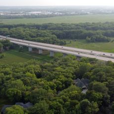
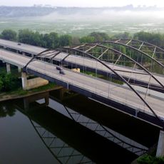
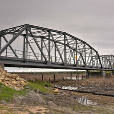
I-35W Minnesota River bridge, Road bridge between Bloomington and Burnsville, United States

The I-35W Minnesota River Bridge is a road bridge between Bloomington and Burnsville with eight traffic lanes serving both directions. The structure spans across the river valley with separate lanes for regular traffic and high-occupancy vehicles in each direction.

The original structure was built in 1960 by the Minnesota Highway Department. It replaced an older US 65 bridge that suffered from frequent flooding problems.

The bridge connects two southern suburbs of Minneapolis and enables daily commutes between both sides of the river. It serves as a vital hub that locals use multiple times daily to reach work, shops, and services.

The bridge features four regular lanes and dedicated MnPass lanes for high-occupancy vehicles in each direction. This arrangement helps manage traffic flow during peak times and offers options for different travel patterns.

The eastern side of the northbound span includes a dedicated path for pedestrians and cyclists. This allows walkers and bike riders an alternative way to cross the Minnesota River beyond vehicle traffic.

The community of curious travelers

AroundUs brings together thousands of curated places, local tips, and hidden gems, enriched daily by 60,000 contributors worldwide.

Start exploring
Location
Location
Inception
1960
Official opening
1960
GPS coordinates
44.80030,-93.29000
Latest update
December 14, 2025 14:21
Around this place
Nickelodeon Universe
United States of America

Nickelodeon Universe

7.1 km
Metropolitan Stadium
United States of America

Metropolitan Stadium

7.1 km
Minnesota Zoo
United States of America

Minnesota Zoo

8 km
SpongeBob SquarePants Rock Bottom Plunge
United States of America

SpongeBob SquarePants Rock Bottom Plunge

7.2 km
Water Park of America
United States of America

Water Park of America

7.4 km
SEA LIFE Minnesota Aquarium
United States of America

SEA LIFE Minnesota Aquarium

7.1 km
Log Chute
United States of America

Log Chute

7.2 km
Sea Life at Mall of America
United States of America

Sea Life at Mall of America

7.1 km
Pepsi Orange Streak
United States of America

Pepsi Orange Streak

7.1 km
Fairly Odd Coaster
United States of America

Fairly Odd Coaster

7.1 km
Bloomington Ferry Bridge
United States of America

Bloomington Ferry Bridge

8.6 km
Cedar Avenue Bridge
United States of America

Cedar Avenue Bridge

5.5 km
Dan Patch Line Bridge
United States of America

Dan Patch Line Bridge

5.1 km
Burnsville Performing Arts Center
United States of America

Burnsville Performing Arts Center

3 km
Centennial Lakes Park
United States of America

Centennial Lakes Park

7.9 km
8500 Tower
United States of America

8500 Tower

7.9 km
Gideon H. Pond House
United States of America

Gideon H. Pond House

2.1 km
Wood Lake Nature Center
United States of America

Wood Lake Nature Center

8.4 km
Bloomington Ferry Trail Bridge
United States of America

Bloomington Ferry Trail Bridge

7.7 km
The Garage
United States of America

The Garage

4 km
Augsburg Park Library
United States of America

Augsburg Park Library

8.2 km
Riley Lucas Bartholomew House
United States of America

Riley Lucas Bartholomew House

8.6 km
Gideon Pond House
United States of America

Gideon Pond House

2.1 km
Avatar Airbender
United States of America

Avatar Airbender

7.1 km
Back at the Barnyard Hayride
United States of America

Back at the Barnyard Hayride

7.1 km
Hyland Lake Park Reserve
United States of America

Hyland Lake Park Reserve

7.3 km
Penn Lake Library
United States of America

Penn Lake Library

5.2 km
Long Meadow Bridge
United States of America

Long Meadow Bridge

5.1 km
Show the full map
Reviews
Share your experience

No review yet

Discussions
Start a discussion...

No discussion yet

« I-35W Minnesota River bridge - Road bridge between Bloomington and Burnsville, United States » is provided by Around Us (aroundus.com). Images and texts are derived from Wikimedia project under a Creative Commons license. You are allowed to copy, distribute, and modify copies of this page, under the conditions set by the license, as long as this note is clearly visible.

Discover hidden gems everywhere you go!

From secret cafés to breathtaking viewpoints, skip the crowded tourist spots and find places that match your style. Our app makes it easy with voice search, smart filtering, route optimization, and insider tips from travelers worldwide. Download now for the complete mobile experience.

Around Us App Screenshot

A unique approach to discovering new places

Le Figaro

All the places worth exploring

France Info

A tailor-made excursion in just a few clicks

20 Minutes

Around Us
Travel Guide & Maps
Download

Send to your phone

QR Code
1

Open the camera app on your mobile.

2

Point at the QR code with your camera. A notification will appear.

3

Tap the notification to open the link.