Enable Location

We need your location to show you interesting places around you

Discover nearby places

Find interesting locations and hidden gems around you

Precise directions

Get accurate directions and distances to places

Your location is never shared with other users. It's only used when you tap the location button.

Bethesda Trolley Trail

Log in to your account

Join the adventure

Create your free account and start exploring (like 60k+ others)

We will send you a code to connect

or
Continue with Google
Continue with Apple
By continuing, you accept our Terms and Conditions and our Privacy Policy

Check your inbox

We've sent a pincode in your inbox. Please enter the code below.

Bethesda Trolley Trail

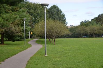
Bethesda Trolley Trail, Rail trail in Montgomery County, United States.

Description

Bethesda Trolley Trail is a rail trail extending 5.9 miles from Twinbrook Metro Station in Rockville to Battery Lane Park in Bethesda. Two specialized bridges cross major interstate highways, providing uninterrupted passage between these endpoints.

History

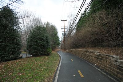
The trail follows the former Tennallytown and Rockville Railroad route, which operated from 1891 until 1935. When streetcar services were discontinued in favor of bus transportation, the right-of-way was later converted into this recreational path.

Culture

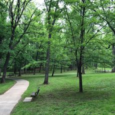
The path links residential neighborhoods with research institutions and passes through sections of the National Institutes of Health campus. Visitors can see how this route serves both commuters traveling daily and people out for recreation.

Practical

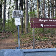
Multiple parking locations serve the trail, with access points at Executive Boulevard in North Bethesda, Fleming Avenue, and Battery Lane. The path is open to both cyclists and pedestrians, making it helpful to identify your preferred starting point before heading out.

Did you know?

The trail uses two major bridges to safely guide cyclists and pedestrians over Interstate 270 and Interstate 495. These overpasses are notable because they enable a continuous route without interruption through the urban area.

i
i
Accessibility
Wheelchair accessible
i
Made from material
rock asphalt
i
GPS coordinates
39.01560,-77.11190
i
Latest update
December 15, 2025 13:28

AroundUs brings together thousands of curated places, local tips, and hidden gems, enriched daily by 60,000 contributors worldwide. Discover all places nearby (Montgomery County).

Around this place
Washington D.C. Temple
United States of America

Washington D.C. Temple

4 km
United States National Library of Medicine
United States of America

United States National Library of Medicine

2.5 km
Columbia Country Club
United States of America

Columbia Country Club

3.3 km
Wilkins Estate
United States of America

Wilkins Estate

5.6 km
Bethesda Meeting House
United States of America

Bethesda Meeting House

1.3 km
Riley-Bolten House
United States of America

Riley-Bolten House

3.3 km
B'nai Israel Congregation
United States of America

B'nai Israel Congregation

4.5 km
Hammond Wood Historic District
United States of America

Hammond Wood Historic District

5.1 km
Montrose School
United States of America

Montrose School

4.2 km
Congregation Beth El
United States of America

Congregation Beth El

2.6 km
Kensington Historic District
United States of America

Kensington Historic District

3.3 km
North Bethesda Market
United States of America

North Bethesda Market

3 km
Rock Creek Woods Historic District
United States of America

Rock Creek Woods Historic District

4.4 km
Cedar Lane Unitarian Universalist Church
United States of America

Cedar Lane Unitarian Universalist Church

2 km
Garrett Park Historic District
United States of America

Garrett Park Historic District

2.7 km
Moreland
United States of America

Moreland

3.1 km
Music Center at Strathmore
United States of America

Music Center at Strathmore

2 km
Mansion at Strathmore
United States of America

Mansion at Strathmore

1.9 km
Wyngate Woods Park
United States of America

Wyngate Woods Park

1.7 km
Noyes Library For Young Children
United States of America

Noyes Library For Young Children

3.5 km
Davis Library
United States of America

Davis Library

1.7 km
Bradley Hills Park
United States of America

Bradley Hills Park

2.7 km
Luxmanor Park
United States of America

Luxmanor Park

3.6 km
St. Jane Frances de Chantal, Bethesda
United States of America

St. Jane Frances de Chantal, Bethesda

491 m
The Ratner Museum
United States of America

The Ratner Museum

916 m
Cabin John Regional Park
United States of America

Cabin John Regional Park

3.8 km
Gifford Pinchot Forest Building
United States of America

Gifford Pinchot Forest Building

677 m
Kensington Park Library
United States of America

Kensington Park Library

3 km
Show the full map
« Bethesda Trolley Trail - Rail trail in Montgomery County, United States » is provided by Around Us (aroundus.com). Images and texts are derived from Wikimedia project under a Creative Commons license. You are allowed to copy, distribute, and modify copies of this page, under the conditions set by the license, as long as this note is clearly visible.

Discover hidden gems everywhere you go!

From secret cafés to breathtaking viewpoints, skip the crowded tourist spots and find places that match your style. Our app makes it easy with voice search, smart filtering, route optimization, and insider tips from travelers worldwide. Download now for the complete mobile experience.

Around Us App Screenshot

A unique approach to discovering new places

Le Figaro

All the places worth exploring

France Info

A tailor-made excursion in just a few clicks

20 Minutes

Around Us
Travel Guide & Maps
Download

Send to your phone

QR Code
1

Open the camera app on your mobile.

2

Point at the QR code with your camera. A notification will appear.

3

Tap the notification to open the link.