Enable Location

We need your location to show you interesting places around you

Discover nearby places

Find interesting locations and hidden gems around you

Precise directions

Get accurate directions and distances to places

Your location is never shared with other users. It's only used when you tap the location button.

Pile–Pontoon Railroad Bridge

Log in to your account

Start exploring — it's free

Trusted by 61,868 travelers worldwide

Continue with Google
Continue with Apple
or

We will send you a code to connect

By continuing, you accept our Terms and Conditions and our Privacy Policy

Check your inbox

We've sent a pincode in your inbox. Please enter the code below.

Pile–Pontoon Railroad Bridge

Pile–Pontoon Railroad Bridge, Railroad bridge in Prairie du Chien, United States

Description

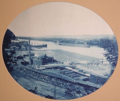
The Pile-Pontoon Railroad Bridge is a railway crossing over the Mississippi River that uses fixed piles and floating pontoons to support railroad tracks above the water. The structure spans the river and allows trains to travel between the two banks.

History

Built in 1884, the bridge solved transportation challenges by allowing trains to cross the river while accommodating river traffic and seasonal ice flows. This design was an engineering response to the Mississippi's natural conditions.

Culture

The bridge marked a turning point for the region, making Prairie du Chien a central transportation hub that connected communities across Iowa and Wisconsin. It became a symbol of how engineering could bring people together across a major river.

Practical

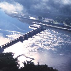
The bridge deck adjusted up to 18 feet vertically to handle changing water levels, while trains crossed at a restricted speed of 7 miles per hour. Visitors should note that the structure was built for train traffic and access may be limited.

Did you know?

The bridge featured two separate pontoon sections that operated independently through steam-powered cables to allow river vessels to pass between them. This split design was an innovative solution for maintaining navigation traffic while supporting trains.

Location
GPS coordinates
43.04389,-91.17583
Latest update
December 14, 2025 11:23

AroundUs brings together thousands of curated places, local tips, and hidden gems, enriched daily by 60,000 contributors worldwide. Discover all places nearby (Marquette).

Around this place
Pikes Peak State Park
United States of America

Pikes Peak State Park

5.3 km
Wyalusing State Park
United States of America

Wyalusing State Park

9 km
Villa Louis
United States of America

Villa Louis

1.9 km
Upper Mississippi River National Wildlife and Fish Refuge
United States of America

Upper Mississippi River National Wildlife and Fish Refuge

18.9 km
Fort Crawford
United States of America

Fort Crawford

2.4 km
Lock and Dam No. 9
United States of America

Lock and Dam No. 9

19.7 km
Brisbois House
United States of America

Brisbois House

1.7 km
Dousman Hotel
United States of America

Dousman Hotel

1.7 km
Astor Fur Warehouse
United States of America

Astor Fur Warehouse

1.8 km
Peter Stauer House
United States of America

Peter Stauer House

2.9 km
W.H.C. Folsom House
United States of America

W.H.C. Folsom House

2.5 km
Francois Vertefeuille House
United States of America

Francois Vertefeuille House

4.9 km
Clayton School
United States of America

Clayton School

15.9 km
Old Rock School
United States of America

Old Rock School

3.3 km
Goedert Meat Market
United States of America

Goedert Meat Market

2.4 km
Joseph "Diamond Jo" Reynolds Office Building and House
United States of America

Joseph "Diamond Jo" Reynolds Office Building and House

2.2 km
Effigy Mounds National Monument Visitor Center
United States of America

Effigy Mounds National Monument Visitor Center

5.1 km
St. Germain dit Gauthier House
United States of America

St. Germain dit Gauthier House

2.2 km
Crawford County Courthouse
United States of America

Crawford County Courthouse

2.7 km
Prairie du Chien City Hall
United States of America

Prairie du Chien City Hall

2.4 km
McGregor Commercial Historic District
United States of America

McGregor Commercial Historic District

2.2 km
I.O.O.F. Hall
United States of America

I.O.O.F. Hall

20.2 km
Strange Powers House
United States of America

Strange Powers House

2.6 km
Commercial Hotel
United States of America

Commercial Hotel

2.4 km
Christian Bloedel Wagon Works
United States of America

Christian Bloedel Wagon Works

2.7 km
Rolette House
United States of America

Rolette House

1.8 km
Fort Crawford Museum
United States of America

Fort Crawford Museum

2.3 km
Marquette–Joliet Bridge
United States of America

Marquette–Joliet Bridge

0 m
Show the full map
« Pile–Pontoon Railroad Bridge - Railroad bridge in Prairie du Chien, United States » is provided by Around Us (aroundus.com). Images and texts are derived from Wikimedia project under a Creative Commons license. You are allowed to copy, distribute, and modify copies of this page, under the conditions set by the license, as long as this note is clearly visible.

Discover hidden gems everywhere you go!

From secret cafés to breathtaking viewpoints, skip the crowded tourist spots and find places that match your style. Our app makes it easy with voice search, smart filtering, route optimization, and insider tips from travelers worldwide. Download now for the complete mobile experience.

Around Us App Screenshot

A unique approach to discovering new places

Le Figaro

All the places worth exploring

France Info

A tailor-made excursion in just a few clicks

20 Minutes

Around Us
Travel Guide & Maps
Download

Send to your phone

QR Code
1

Open the camera app on your mobile.

2

Point at the QR code with your camera. A notification will appear.

3

Tap the notification to open the link.