Enable Location

We need your location to show you interesting places around you

Discover nearby places

Find interesting locations and hidden gems around you

Precise directions

Get accurate directions and distances to places

Your location is never shared with other users. It's only used when you tap the location button.

Pilot Island Light

Log in to your account

Start exploring — it's free

Trusted by 61,917 travelers worldwide

Continue with Google
Continue with Apple
or

We will send you a code to connect

By continuing, you accept our Terms and Conditions and our Privacy Policy

Check your inbox

We've sent a pincode in your inbox. Please enter the code below.

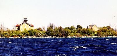
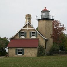
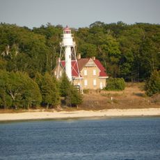
Pilot Island Light, 1858 lighthouse in Door County, United States.

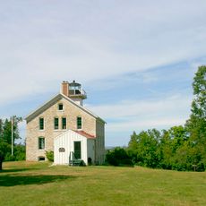
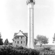
Pilot Island Light is a square stone structure standing 12 meters tall on a Lake Michigan shoreline in Door County. The tower features walls of Milwaukee Cream City brick with a distinctive yellow lantern topped by a black roof section.

The structure was built in the 1850s to guide vessels safely through the hazardous Death's Door shipping channel. An earlier lighthouse on a nearby island had proven insufficient for this dangerous stretch of water.

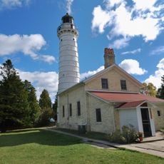
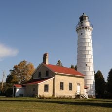
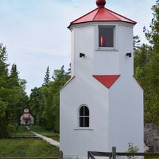
The structure serves as a symbol of maritime heritage in the region and appears prominently in local water-based tours. People recognize it as a reminder of the area's connection to shipping and navigation history.

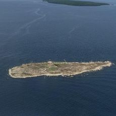
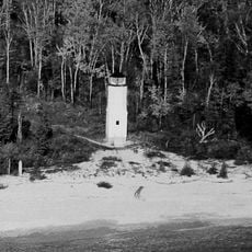
The structure sits on an island and remains closed to public visits as it lies within a wildlife refuge. Boat tours and water-based excursions offer the best opportunity to view it from a distance.

A former lighthouse keeper received recognition for rescuing eight sailors from a sinking vessel during a severe storm in the 1890s. The dramatic incident occurred near the treacherous reef that this light was meant to protect against.

The community of curious travelers

AroundUs brings together thousands of curated places, local tips, and hidden gems, enriched daily by 60,000 contributors worldwide.

Start exploring
Location
Inception
1858
Height
12 m
Made from material
stone
GPS coordinates
45.28439,-86.91958
Latest update
December 13, 2025 11:45
Around this place
Peninsula State Park
United States of America

Peninsula State Park

27.7 km
Cana Island
United States of America

Cana Island

24.1 km
Cana Island Light
United States of America

Cana Island Light

24 km
Newport State Park
United States of America

Newport State Park

8 km
Rock Island State Park
United States of America

Rock Island State Park

16.6 km
Pilot Island
United States of America

Pilot Island

69 m
Baileys Harbor Range Lights
United States of America

Baileys Harbor Range Lights

28.4 km
The Clearing Folk School
United States of America

The Clearing Folk School

12.2 km
Pottawatomie Light
United States of America

Pottawatomie Light

17.5 km
The Ridges Sanctuary
United States of America

The Ridges Sanctuary

28.3 km
Green Bay National Wildlife Refuge
United States of America

Green Bay National Wildlife Refuge

4.3 km
Eagle Bluff Light
United States of America

Eagle Bluff Light

28 km
United States of America

Mero Site

19.1 km
Gravel Island National Wildlife Refuge
United States of America

Gravel Island National Wildlife Refuge

10.3 km
St. Martin Island Light
United States of America

St. Martin Island Light

27.4 km
Ephraim Moravian Church
United States of America

Ephraim Moravian Church

24.3 km
Free Evangelical Lutheran Church-Bethania Scandinavian Evangelical Lutheran Congregation
United States of America

Free Evangelical Lutheran Church-Bethania Scandinavian Evangelical Lutheran Congregation

24.2 km
Gibraltar District School No. 2
United States of America

Gibraltar District School No. 2

24.2 km
School House Beach Park
United States of America

School House Beach Park

12.6 km
Thordarson Estate Historic District
United States of America

Thordarson Estate Historic District

15.8 km
Water Tower
United States of America

Water Tower

16.8 km
Ephraim Village Hall
United States of America

Ephraim Village Hall

24.3 km
Peter Peterson House
United States of America

Peter Peterson House

24.2 km
Baileys Harbor Range Front Light
United States of America

Baileys Harbor Range Front Light

28.5 km
Jacobsen Museum
United States of America

Jacobsen Museum

13.8 km
Washington Island Farm Museum
United States of America

Washington Island Farm Museum

12.2 km
Plum Island Range rear light
United States of America

Plum Island Range rear light

4 km
Plum Island Range front light
United States of America

Plum Island Range front light

3.5 km
Show the full map
« Pilot Island Light - 1858 lighthouse in Door County, United States » is provided by Around Us (aroundus.com). Images and texts are derived from Wikimedia project under a Creative Commons license. You are allowed to copy, distribute, and modify copies of this page, under the conditions set by the license, as long as this note is clearly visible.

Discover hidden gems everywhere you go!

From secret cafés to breathtaking viewpoints, skip the crowded tourist spots and find places that match your style. Our app makes it easy with voice search, smart filtering, route optimization, and insider tips from travelers worldwide. Download now for the complete mobile experience.

Around Us App Screenshot

A unique approach to discovering new places

Le Figaro

All the places worth exploring

France Info

A tailor-made excursion in just a few clicks

20 Minutes

Around Us
Travel Guide & Maps
Download

Send to your phone

QR Code
1

Open the camera app on your mobile.

2

Point at the QR code with your camera. A notification will appear.

3

Tap the notification to open the link.